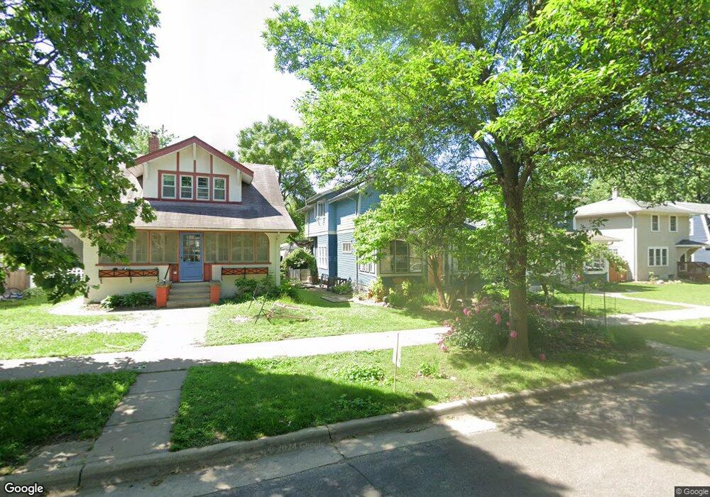
1952 Wellesley Ave Saint Paul, MN 55105
Macalester-Groveland NeighborhoodEstimated Value: $544,000 - $576,000
3
Beds
3
Baths
1,372
Sq Ft
$407/Sq Ft
Est. Value
About This Home
This home is located at 1952 Wellesley Ave, Saint Paul, MN 55105 and is currently estimated at $558,443, approximately $407 per square foot. 1952 Wellesley Ave is a home located in Ramsey County with nearby schools including Groveland Park Elementary School, Hidden River Middle School, and Central Senior High School.
Ownership History
Date
Name
Owned For
Owner Type
Purchase Details
Closed on
May 2, 2007
Sold by
Hsbc Mortgage Services Inc
Bought by
Lodahl Jennifer E and Lodahl Matthew R
Current Estimated Value
Purchase Details
Closed on
Dec 14, 2005
Sold by
Larson Kurt
Bought by
Larson Greg Randall
Purchase Details
Closed on
Oct 30, 2003
Sold by
Larson Kurt
Bought by
Larson Greg Randall and Larson Karen Elise
Purchase Details
Closed on
Feb 24, 2000
Sold by
Berg B James and Kruger Mary J
Bought by
Larson Greg Randall and Berg Larson Karrin Elise
Create a Home Valuation Report for This Property
The Home Valuation Report is an in-depth analysis detailing your home's value as well as a comparison with similar homes in the area
Home Values in the Area
Average Home Value in this Area
Purchase History
| Date | Buyer | Sale Price | Title Company |
|---|---|---|---|
| Lodahl Jennifer E | $339,900 | -- | |
| Larson Greg Randall | $296,621 | -- | |
| Larson Greg Randall | $296,621 | -- | |
| Larson Greg Randall | $93,000 | -- |
Source: Public Records
Mortgage History
| Date | Status | Borrower | Loan Amount |
|---|---|---|---|
| Closed | Larson Greg Randall | -- |
Source: Public Records
Tax History Compared to Growth
Tax History
| Year | Tax Paid | Tax Assessment Tax Assessment Total Assessment is a certain percentage of the fair market value that is determined by local assessors to be the total taxable value of land and additions on the property. | Land | Improvement |
|---|---|---|---|---|
| 2025 | $7,780 | $555,100 | $126,000 | $429,100 |
| 2023 | $7,780 | $504,600 | $126,000 | $378,600 |
| 2022 | $6,972 | $491,300 | $126,000 | $365,300 |
| 2021 | $6,960 | $431,000 | $126,000 | $305,000 |
| 2020 | $7,368 | $446,500 | $126,000 | $320,500 |
| 2019 | $7,346 | $438,900 | $126,000 | $312,900 |
| 2018 | $6,740 | $432,100 | $126,000 | $306,100 |
| 2017 | $5,708 | $408,100 | $126,000 | $282,100 |
| 2016 | $5,894 | $0 | $0 | $0 |
| 2015 | $5,148 | $359,300 | $113,400 | $245,900 |
| 2014 | $4,814 | $0 | $0 | $0 |
Source: Public Records
Map
Nearby Homes
- 281 Cleveland Ave S
- 1818 Juliet Ave
- 2129 Stanford Ave
- 2133 Berkeley Ave
- 1797 James Ave
- 188 Cleveland Ave S
- 2114 Randolph Ave
- 1926 Lincoln Ave
- 475 Mount Curve Blvd
- 590 Fairview Ave S
- 1688 James Ave
- 313 Stonebridge Blvd
- 317 Stonebridge Blvd
- 2009 Grand Ave
- 191 Vernon St
- 2047 Grand Ave
- 2250 Princeton Ave
- 2056 Summit Ave
- 1615 Stanford Ave
- 677 Wilder St S
- 1958 Wellesley Ave
- 1950 Wellesley Ave
- 1946 Wellesley Ave
- 1962 Wellesley Ave
- 1940 Wellesley Ave
- 1964 Wellesley Ave
- 1953 Jefferson Ave
- 1957 Jefferson Ave
- 1949 Jefferson Ave
- 1968 Wellesley Ave
- 1961 Jefferson Ave
- 1945 Jefferson Ave
- 1955 Wellesley Ave
- 1965 Jefferson Ave
- 1959 Wellesley Ave
- 1949 Wellesley Ave
- 1972 Wellesley Ave
- 1963 Wellesley Ave
- 1969 Jefferson Ave
- 1941 Wellesley Ave