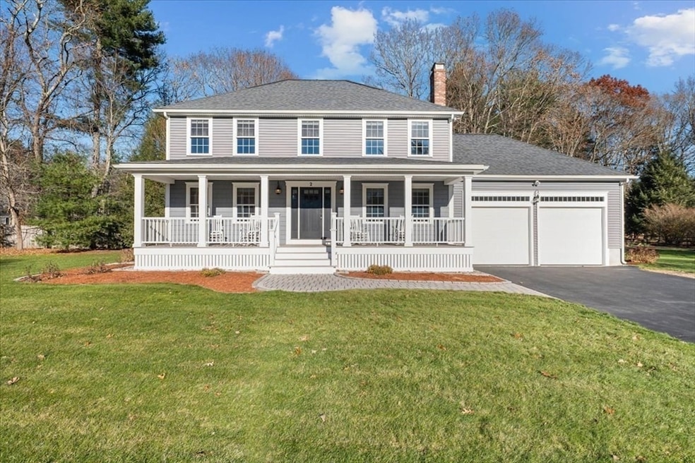
2 Kayla Dr Franklin, MA 02038
Estimated payment $5,426/month
Highlights
- Golf Course Community
- Medical Services
- Colonial Architecture
- Oak Street Elementary School Rated A-
- Custom Closet System
- Landscaped Professionally
About This Home
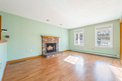
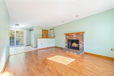
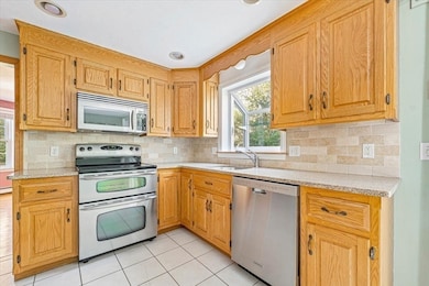
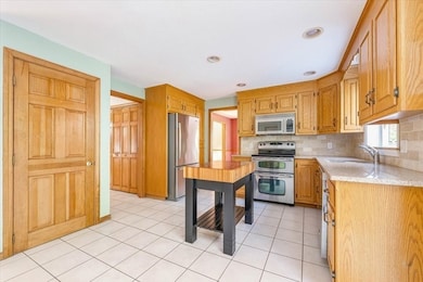
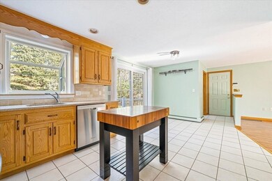
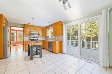
Welcome to 2 Kayla Drive! This beautifully maintained 4-bedroom, 2.5-bath Colonial is perfectly situated in a highly sought-after neighborhood. Offering the ideal blend of style, comfort, and peace of mind, this home features numerous recent upgrades, including new siding, windows, roof, and central air conditioning—providing long-term durability and energy efficiency.The inviting oversized farmer’s porch sets the tone for this warm and welcoming home. Step inside to find a spacious family room with a cozy fireplace, perfect for relaxing or entertaining. The large eat-in kitchen includes ample cabinet space and a slider leading to a brand-new deck & patio that overlooks a private, level backyard—ideal for gatherings, gardening, or outdoor play.Upstairs, the primary suite boasts a private full bath and a large walk-in closet. Three additional bedrooms all offer great natural light and generous closet space. Additional features include a full basement/workshop with expansion potential.
Home Details
Home Type
- Single Family
Est. Annual Taxes
- $8,510
Year Built
- Built in 1994
Lot Details
- 0.7 Acre Lot
- Landscaped Professionally
- Corner Lot
- Level Lot
Parking
- 2 Car Attached Garage
- Parking Storage or Cabinetry
- Workshop in Garage
- Driveway
- Open Parking
Home Design
- Colonial Architecture
- Frame Construction
- Shingle Roof
- Concrete Perimeter Foundation
Interior Spaces
- 1,906 Sq Ft Home
- 1 Fireplace
- Insulated Windows
- Window Screens
- Insulated Doors
- Home Security System
Kitchen
- Range
- Microwave
- Dishwasher
Flooring
- Wood
- Laminate
- Ceramic Tile
Bedrooms and Bathrooms
- 4 Bedrooms
- Primary Bedroom on Main
- Custom Closet System
- Walk-In Closet
Laundry
- Laundry on main level
- Dryer
- Washer
Basement
- Basement Fills Entire Space Under The House
- Sump Pump
Outdoor Features
- Bulkhead
- Deck
- Rain Gutters
- Porch
Location
- Property is near public transit
- Property is near schools
Schools
- Oak Street Elementary School
- Horace Mann Middle School
- FHS High School
Utilities
- Central Air
- 2 Cooling Zones
- 2 Heating Zones
- Heating System Uses Oil
- Baseboard Heating
- 200+ Amp Service
- Water Heater
- Private Sewer
Listing and Financial Details
- Assessor Parcel Number M:251 L:077,94036
Community Details
Overview
- No Home Owners Association
- Near Conservation Area
Amenities
- Medical Services
- Shops
Recreation
- Golf Course Community
- Park
- Jogging Path
- Bike Trail
Map
Home Values in the Area
Average Home Value in this Area
Tax History
| Year | Tax Paid | Tax Assessment Tax Assessment Total Assessment is a certain percentage of the fair market value that is determined by local assessors to be the total taxable value of land and additions on the property. | Land | Improvement |
|---|---|---|---|---|
| 2025 | $8,510 | $732,400 | $363,500 | $368,900 |
| 2024 | $8,635 | $732,400 | $363,500 | $368,900 |
| 2023 | $8,463 | $672,700 | $337,300 | $335,400 |
| 2022 | $8,257 | $587,700 | $290,800 | $296,900 |
| 2021 | $7,929 | $541,200 | $278,900 | $262,300 |
| 2020 | $7,714 | $531,600 | $281,700 | $249,900 |
| 2019 | $7,746 | $528,400 | $278,900 | $249,500 |
| 2018 | $7,337 | $500,800 | $276,100 | $224,700 |
| 2017 | $7,424 | $509,200 | $284,600 | $224,600 |
| 2016 | $6,782 | $467,700 | $246,200 | $221,500 |
| 2015 | $6,812 | $459,000 | $237,500 | $221,500 |
| 2014 | $6,349 | $439,400 | $217,900 | $221,500 |
Property History
| Date | Event | Price | List to Sale | Price per Sq Ft |
|---|---|---|---|---|
| 11/20/2025 11/20/25 | For Sale | $895,000 | -- | $470 / Sq Ft |
Purchase History
| Date | Type | Sale Price | Title Company |
|---|---|---|---|
| Deed | $214,000 | -- |
Mortgage History
| Date | Status | Loan Amount | Loan Type |
|---|---|---|---|
| Closed | $35,000 | No Value Available | |
| Closed | $203,000 | Purchase Money Mortgage |
Source: MLS Property Information Network (MLS PIN)
MLS Number: 73450711
APN: FRAN-000251-000000-000077
Disclaimer: Certain information contained herein is derived from information provided by parties other than Homes.com. All information provided is deemed reliable, but is not guaranteed to be accurate and should be independently verified.
![]() The property listing data and information, or the Images, set forth herein were provided to MLS Property Information Network, Inc. from third party sources, including sellers, lessors and public records, and were compiled by MLS Property Information Network, Inc. The property listing data and information, and the Images, are for the personal, non-commercial use of consumers having a good faith interest in purchasing or leasing listed properties of the type displayed to them and may not be used for any purpose other than to identify prospective properties which such consumers may have a good faith interest in purchasing or leasing. MLS Property Information Network, Inc. and its subscribers disclaim any and all representations and warranties as to the accuracy of the property listing data and information, or as to the accuracy of any of the Images, set forth herein.
The property listing data and information, or the Images, set forth herein were provided to MLS Property Information Network, Inc. from third party sources, including sellers, lessors and public records, and were compiled by MLS Property Information Network, Inc. The property listing data and information, and the Images, are for the personal, non-commercial use of consumers having a good faith interest in purchasing or leasing listed properties of the type displayed to them and may not be used for any purpose other than to identify prospective properties which such consumers may have a good faith interest in purchasing or leasing. MLS Property Information Network, Inc. and its subscribers disclaim any and all representations and warranties as to the accuracy of the property listing data and information, or as to the accuracy of any of the Images, set forth herein.
- 336 Maple St
- 6 Lydia Ln
- 41 Kimberlee Ave
- 17 Longhill Rd
- 48 Pinehurst St
- 208 Irondequoit Rd
- 66 Highwood Dr
- 159 Highwood Dr
- 83 Highwood Dr Unit 83
- 134 Highwood Dr
- 150 Pleasant St
- 57 Raymond St Unit 2
- 1805 Franklin Crossing Rd
- 2 Noanet Brook Ln
- 60 Southgate Rd
- 266 Pleasant St
- 605 Franklin Crossing Rd
- 0 Upper Union St Unit 73230551
- 6 Buena Vista Dr
- 324 Pleasant St
- 1410 Franklin Crossing Rd
- 809 Franklin Crossing Rd Unit 809
- 125 Main St Unit 1
- 117 Dean Ave
- 18 E Central St Unit 4
- 139 E Central St Unit 2
- 301 Union St
- 12 Uncas Ave Unit 11
- 300 Glen Meadow Rd
- 330 E Central St
- 1-8 Gatehouse Ln
- 15 Hawthorne Village Unit D
- 146 Village St Unit 3
- 50 Woodview Way
- 835 Upper Union St
- 10 Independence Way
- 1 West St
- 5 Eagle Brook Blvd Unit 95
- 5 Eagle Brook Blvd Unit 81
- 5 Eagle Brook Blvd Unit 125
