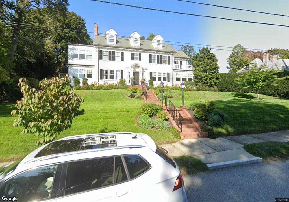
200 Kent Rd Waban, MA 02468
Waban NeighborhoodEstimated Value: $3,377,000 - $3,755,000
5
Beds
4
Baths
4,758
Sq Ft
$743/Sq Ft
Est. Value
About This Home
This home is located at 200 Kent Rd, Waban, MA 02468 and is currently estimated at $3,536,347, approximately $743 per square foot. 200 Kent Rd is a home located in Middlesex County with nearby schools including Angier Elementary School, Charles E Brown Middle School, and Newton South High School.
Ownership History
Date
Name
Owned For
Owner Type
Purchase Details
Closed on
Apr 10, 2014
Sold by
John F Levy T
Bought by
Drachman Douglas and Mayer Erica
Current Estimated Value
Home Financials for this Owner
Home Financials are based on the most recent Mortgage that was taken out on this home.
Original Mortgage
$1,100,000
Outstanding Balance
$837,150
Interest Rate
4.37%
Mortgage Type
Purchase Money Mortgage
Estimated Equity
$2,699,197
Purchase Details
Closed on
Oct 17, 2012
Sold by
Levy John F
Bought by
Qprt John F Levy and Levy John F
Create a Home Valuation Report for This Property
The Home Valuation Report is an in-depth analysis detailing your home's value as well as a comparison with similar homes in the area
Home Values in the Area
Average Home Value in this Area
Purchase History
| Date | Buyer | Sale Price | Title Company |
|---|---|---|---|
| Drachman Douglas | $2,150,000 | -- | |
| Qprt John F Levy | -- | -- |
Source: Public Records
Mortgage History
| Date | Status | Borrower | Loan Amount |
|---|---|---|---|
| Open | Drachman Douglas | $1,100,000 |
Source: Public Records
Tax History
| Year | Tax Paid | Tax Assessment Tax Assessment Total Assessment is a certain percentage of the fair market value that is determined by local assessors to be the total taxable value of land and additions on the property. | Land | Improvement |
|---|---|---|---|---|
| 2025 | $33,114 | $3,379,000 | $1,599,300 | $1,779,700 |
| 2024 | $32,019 | $3,280,600 | $1,552,700 | $1,727,900 |
| 2023 | $30,939 | $3,039,200 | $1,218,100 | $1,821,100 |
| 2022 | $29,604 | $2,814,100 | $1,127,900 | $1,686,200 |
| 2021 | $28,267 | $2,627,000 | $1,064,100 | $1,562,900 |
| 2020 | $26,748 | $2,562,100 | $1,064,100 | $1,498,000 |
| 2019 | $25,994 | $2,487,500 | $1,033,100 | $1,454,400 |
| 2018 | $25,542 | $2,360,600 | $934,500 | $1,426,100 |
| 2017 | $24,764 | $2,360,600 | $934,500 | $1,426,100 |
| 2016 | $23,685 | $2,081,300 | $823,900 | $1,257,400 |
| 2015 | $22,267 | $1,917,900 | $770,000 | $1,147,900 |
Source: Public Records
Map
Nearby Homes
- 115 Windsor Rd
- 29 Montclair Rd
- 20 Kinmonth Rd Unit 203
- 20 Kinmonth Rd Unit 306
- 20 Kinmonth Rd Unit 4
- 18 Moffat Rd
- 0 Metacomet Rd
- 33 Metacomet Rd
- 110 Avalon Rd
- 15 Gammons Rd
- 91 Waban Ave
- 19 Gordon Rd
- 1438 Beacon St
- 81 Fuller St
- 34 Larchmont Ave
- 31 Wilde Rd
- 55 Evelyn Rd
- 1754 Washington St
- 155 Paulson Rd
- 64 Varick Rd
Your Personal Tour Guide
Ask me questions while you tour the home.