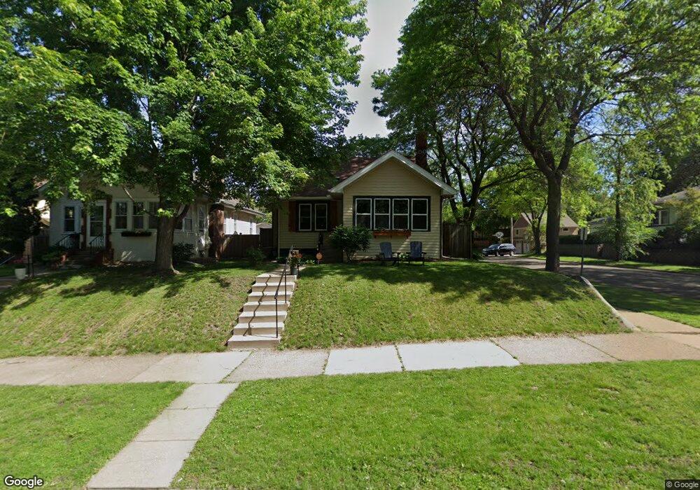
2003 James Ave Saint Paul, MN 55105
Macalester-Groveland NeighborhoodEstimated Value: $428,000 - $444,000
3
Beds
2
Baths
1,030
Sq Ft
$421/Sq Ft
Est. Value
About This Home
This home is located at 2003 James Ave, Saint Paul, MN 55105 and is currently estimated at $433,119, approximately $420 per square foot. 2003 James Ave is a home located in Ramsey County with nearby schools including Groveland Park Elementary School, Stockton Borough School, and Hidden River Middle School.
Ownership History
Date
Name
Owned For
Owner Type
Purchase Details
Closed on
Oct 8, 2019
Sold by
Banks Taylor R and Banks Heidi A
Bought by
Ruden Kelly Anne Von
Current Estimated Value
Home Financials for this Owner
Home Financials are based on the most recent Mortgage that was taken out on this home.
Original Mortgage
$305,100
Outstanding Balance
$267,283
Interest Rate
3.5%
Mortgage Type
New Conventional
Estimated Equity
$165,836
Create a Home Valuation Report for This Property
The Home Valuation Report is an in-depth analysis detailing your home's value as well as a comparison with similar homes in the area
Home Values in the Area
Average Home Value in this Area
Purchase History
| Date | Buyer | Sale Price | Title Company |
|---|---|---|---|
| Ruden Kelly Anne Von | $339,000 | Titlenexus Llc |
Source: Public Records
Mortgage History
| Date | Status | Borrower | Loan Amount |
|---|---|---|---|
| Open | Ruden Kelly Anne Von | $305,100 |
Source: Public Records
Tax History Compared to Growth
Tax History
| Year | Tax Paid | Tax Assessment Tax Assessment Total Assessment is a certain percentage of the fair market value that is determined by local assessors to be the total taxable value of land and additions on the property. | Land | Improvement |
|---|---|---|---|---|
| 2025 | $6,032 | $401,300 | $123,600 | $277,700 |
| 2023 | $6,032 | $384,200 | $123,600 | $260,600 |
| 2022 | $5,370 | $376,800 | $123,600 | $253,200 |
| 2021 | $4,888 | $325,400 | $123,600 | $201,800 |
| 2020 | $5,432 | $307,600 | $123,600 | $184,000 |
| 2019 | $5,164 | $329,100 | $123,600 | $205,500 |
| 2018 | $4,480 | $310,400 | $123,600 | $186,800 |
| 2017 | $3,804 | $280,300 | $123,600 | $156,700 |
| 2016 | $3,964 | $0 | $0 | $0 |
| 2015 | $3,278 | $246,000 | $111,200 | $134,800 |
| 2014 | $2,882 | $0 | $0 | $0 |
Source: Public Records
Map
Nearby Homes
- 2084 Palace Ave
- 2078 Stanford Ave
- 1926 Saint Clair Ave
- 590 Cretin Ave S
- 1885 Eleanor Ave
- 31X Stonebridge Blvd
- 313 Stonebridge Blvd
- 317 Stonebridge Blvd
- 1856 Highland Pkwy
- 1941 Ford Pkwy Unit 102
- 2250 Princeton Ave
- 1926 Grand Ave
- 1615 Stanford Ave
- 1778 Ford Pkwy
- 2056 Summit Ave
- 142 Cambridge St
- TBD Scheffer Ave
- 388 Snelling Ave S
- 1591 Berkeley Ave
- 580 Snelling Ave S Unit 4
- 2007 James Ave
- 1997 James Ave
- 2015 James Ave
- 1993 James Ave
- 2002 Palace Ave
- 2006 Palace Ave
- 2019 James Ave
- 2010 Palace Ave
- 1996 Palace Ave
- 1989 James Ave
- 2002 James Ave
- 2004 James Ave
- 2021 James Ave
- 1992 Palace Ave
- 2008 James Ave
- 2016 Palace Ave
- 1998 James Ave
- 1985 James Ave
- 2012 James Ave
- 1988 Palace Ave