
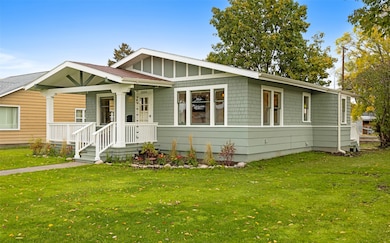
2004 S 10th St W Missoula, MT 59801
Franklin to the Fort NeighborhoodEstimated payment $2,995/month
Highlights
- Mountain View
- No HOA
- Landscaped
- Hellgate High School Rated A-
- Covered Patio or Porch
- 3-minute walk to Franklin Park
About This Home
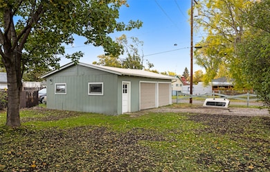
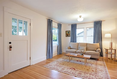
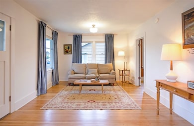
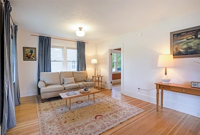
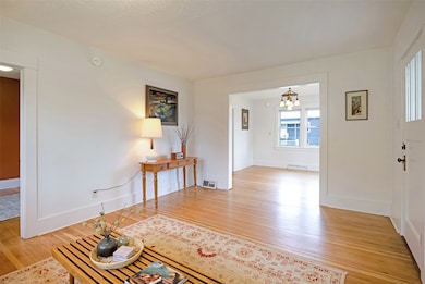
Centrally located and freshly remodeled, this Missoula home perfectly blends classic charm with modern updates. Set on a 0.187 acre lot, the home offers 3 bedrooms and 1 bath across 1,080 Sq Ft on the main level, plus an additional 300 Sq Ft of unfinished lower-level space for storage or future expansion. The home has been fully updated inside and out, featuring a new furnace, water heater, upgraded electrical and plumbing systems, fresh exterior and interior paint, beautifully refinished original larch wood flooring, plus more. The kitchen has been completely remodeled with butcher block countertops, a custom tiled backsplash, and modern finishes throughout. Outside, you’ll find new landscaping and a large detached two-car garage. Zoned RM1-45, this property also offers excellent future development potential. With its prime central location and turnkey condition, this is a standout opportunity in the heart of Missoula.
Listing Agent
Engel & Völkers Western Frontier - Missoula License #RRE-BRO-LIC-123486 Listed on: 10/15/2025

Co-Listing Agent
Engel & Völkers Western Frontier - Missoula License #RRE-RBS-LIC-108369
Home Details
Home Type
- Single Family
Est. Annual Taxes
- $4,379
Year Built
- Built in 1960
Lot Details
- 8,146 Sq Ft Lot
- Landscaped
- Level Lot
- Front Yard
- Zoning described as RM1-45
Parking
- 2 Car Garage
- On-Street Parking
Home Design
- Poured Concrete
- Asphalt Roof
Interior Spaces
- 1,380 Sq Ft Home
- Property has 1 Level
- Mountain Views
- Oven or Range
- Unfinished Basement
Bedrooms and Bathrooms
- 3 Bedrooms
- 1 Full Bathroom
Outdoor Features
- Covered Patio or Porch
- Rain Gutters
Utilities
- Forced Air Heating System
- Heating System Uses Gas
- Natural Gas Connected
- High Speed Internet
- Phone Available
- Cable TV Available
Community Details
- No Home Owners Association
Listing and Financial Details
- Assessor Parcel Number 04220029249250000
Map
Home Values in the Area
Average Home Value in this Area
Tax History
| Year | Tax Paid | Tax Assessment Tax Assessment Total Assessment is a certain percentage of the fair market value that is determined by local assessors to be the total taxable value of land and additions on the property. | Land | Improvement |
|---|---|---|---|---|
| 2025 | $4,379 | $329,400 | $229,694 | $99,706 |
| 2024 | $2,617 | $375,000 | $169,650 | $205,350 |
| 2023 | $2,528 | $375,000 | $169,650 | $205,350 |
| 2022 | $1,763 | $271,400 | $0 | $0 |
| 2021 | $1,353 | $271,400 | $0 | $0 |
| 2020 | $859 | $225,000 | $0 | $0 |
| 2019 | $857 | $225,000 | $0 | $0 |
| 2018 | $1,293 | $190,400 | $0 | $0 |
| 2017 | $2,281 | $190,400 | $0 | $0 |
| 2016 | $2,351 | $186,100 | $0 | $0 |
| 2015 | $2,175 | $186,100 | $0 | $0 |
| 2014 | $1,953 | $94,181 | $0 | $0 |
Property History
| Date | Event | Price | List to Sale | Price per Sq Ft |
|---|---|---|---|---|
| 10/15/2025 10/15/25 | For Sale | $499,000 | -- | $362 / Sq Ft |
Purchase History
| Date | Type | Sale Price | Title Company |
|---|---|---|---|
| Warranty Deed | -- | Fidelity National Title | |
| Deed Of Distribution | -- | None Listed On Document | |
| Quit Claim Deed | -- | None Listed On Document | |
| Deed | -- | None Listed On Document | |
| Interfamily Deed Transfer | -- | -- |
Source: Montana Regional MLS
MLS Number: 30059880
APN: 04-2200-29-2-49-25-0000
Disclaimer: Certain information contained herein is derived from information provided by parties other than Homes.com. All information provided is deemed reliable, but is not guaranteed to be accurate and should be independently verified.
![]() IDX information is provided exclusively for personal, non-commercial use, and may not be used for any purpose other than to identify prospective properties consumers may be interested in purchasing. Information is deemed reliable but not guaranteed.
IDX information is provided exclusively for personal, non-commercial use, and may not be used for any purpose other than to identify prospective properties consumers may be interested in purchasing. Information is deemed reliable but not guaranteed.
- 920 S Johnson St
- 1815 S 8th St W
- 1936 S 7th St W
- 2040 S 12th St W
- 1935 S 12th St W
- 2004 S 13th St W
- NHN S 13th St W Unit Lot 9A
- 2225 S 8th St W
- 2214 S 12th St W
- 1635 S 8th St W
- 2216 S 12th St W
- 1310 Linnea Ln
- 731 Schilling St
- 2220 S 13th St W
- 2128 S 14th St W
- 2223 S 5th St W
- 2124 S 14th St W
- 1854 S 4th St W
- 1421 Eaton St Unit 25
- 2222 S 14th St W
- 1949 S 9th St W Unit B
- 680 S Johnson St Unit 2
- 680 S Johnson St Unit 1
- 1910 Strand Ave Unit 201
- 1910 Strand Ave Unit 101
- 926 Cleveland St Unit . B
- 1580 Milwaukee Way
- 1269 S 1st St W Unit B
- 155 N California St
- 2075 Cooper St
- 419 S 3rd St W Unit C
- 1523 Ernest Ave Unit C
- 2300 McDonald Ave Unit 2
- 102 Mcleod Ave Unit B
- 825 W Spruce St
- 2200 Great Northern Ave
- 1500 Stoddard St
- 301 Kiwanis St
- 305 E Front St
- 411 W Alder St Unit . 7