S
Seller's Agent in 2025
Sharp Homes Team
Epique Realty
(816) 522-4531
6 in this area
410 Total Sales

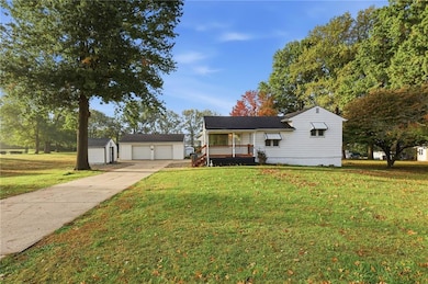
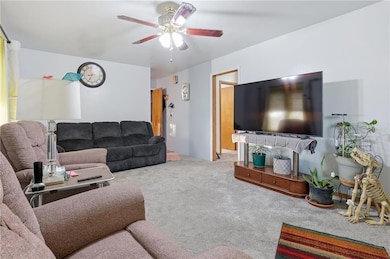

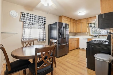
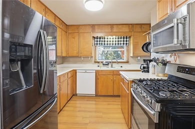
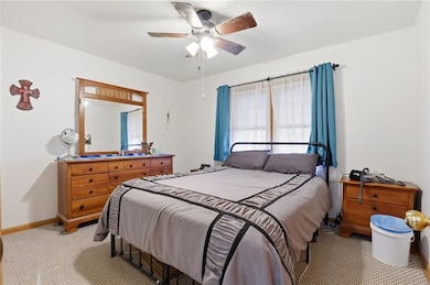
Who says you have to move to the country for elbow room! Sitting on just almost an acre and a half in town, this Independence property offers space, versatility, and plenty of potential. The home includes 4 bedrooms and 3 full baths, with updates that make it move-in ready while leaving room to make it your own. The kitchen has a clean, functional layout, perfect for everyday life or casual gatherings. Outside, you’ll find an oversized two-car garage with shop space, an extra one-car building out back, and another storage shed for tools, equipment, or hobbies. The large yard with mature trees gives you room to spread out — ideal for pets, gardening, or weekend get-togethers. The finished lower level includes a second living quarters with a kitchen, living room, and full conforming bedroom, offering flexibility for a family member, guest suite, or income opportunity. Located just minutes from parks, schools, and historic downtown Independence, this home gives you the convenience of in-town living with the space and freedom of a country lot.
| Date | Type | Sale Price | Title Company |
|---|---|---|---|
| Warranty Deed | $232,500 | Alliance National Title Agency | |
| Warranty Deed | -- | -- | |
| Personal Reps Deed | $65,000 | -- |
| Date | Status | Loan Amount | Loan Type |
|---|---|---|---|
| Open | $186,000 | New Conventional | |
| Previous Owner | $97,850 | VA |
| Date | Event | Price | List to Sale | Price per Sq Ft |
|---|---|---|---|---|
| 12/11/2025 12/11/25 | Sold | -- | -- | -- |
| 11/12/2025 11/12/25 | Pending | -- | -- | -- |
| 10/31/2025 10/31/25 | For Sale | $240,000 | -- | $98 / Sq Ft |
| Year | Tax Paid | Tax Assessment Tax Assessment Total Assessment is a certain percentage of the fair market value that is determined by local assessors to be the total taxable value of land and additions on the property. | Land | Improvement |
|---|---|---|---|---|
| 2025 | $2,559 | $37,440 | $6,962 | $30,478 |
| 2024 | $2,559 | $36,930 | $13,283 | $23,647 |
| 2023 | $2,500 | $36,930 | $2,565 | $34,365 |
| 2022 | $2,091 | $28,310 | $4,095 | $24,215 |
| 2021 | $2,090 | $28,310 | $4,095 | $24,215 |
| 2020 | $1,876 | $24,684 | $4,095 | $20,589 |
| 2019 | $1,846 | $24,684 | $4,095 | $20,589 |
| 2018 | $1,785 | $22,794 | $4,442 | $18,352 |
| 2017 | $1,757 | $22,794 | $4,442 | $18,352 |
| 2016 | $1,757 | $22,212 | $7,828 | $14,384 |
| 2014 | $1,669 | $21,565 | $7,600 | $13,965 |
S
Seller's Agent in 2025
Sharp Homes Team
Epique Realty
(816) 522-4531
6 in this area
410 Total Sales

Seller Co-Listing Agent in 2025
Dawn Sharp
Epique Realty
(816) 522-4531
2 in this area
189 Total Sales
Buyer's Agent in 2025
Nestor Zuluaga
Weichert, Realtors Welch & Co.
(816) 728-1213
2 in this area
163 Total Sales
Source: Heartland MLS
MLS Number: 2584000
APN: 26-820-03-63-00-0-00-000
Disclaimer: Certain information contained herein is derived from information provided by parties other than Homes.com. All information provided is deemed reliable, but is not guaranteed to be accurate and should be independently verified.
![]() Based on information submitted to the MLS Grid. All data is obtained from various sources and may not have been verified by broker or MLS GRID. Supplied Open House Information is subject to change without notice. All information should be independently reviewed and verified for accuracy. Properties may or may not be listed by the office/agent presenting the information. Some IDX listings have been excluded from this website. Prices displayed on all Sold listings are the Last Known Listing Price and may not be the actual selling price.
Based on information submitted to the MLS Grid. All data is obtained from various sources and may not have been verified by broker or MLS GRID. Supplied Open House Information is subject to change without notice. All information should be independently reviewed and verified for accuracy. Properties may or may not be listed by the office/agent presenting the information. Some IDX listings have been excluded from this website. Prices displayed on all Sold listings are the Last Known Listing Price and may not be the actual selling price.
Listing Information presented by local MLS brokerage: TEN-X, INC., local REALTOR®- Arlene Richardson - (888) 952-6393
Based on information submitted to the MLS GRID.
Ask me questions while you tour the home.