Estimated Value: $273,500 - $298,000
3
Beds
2
Baths
2,134
Sq Ft
$133/Sq Ft
Est. Value
About This Home
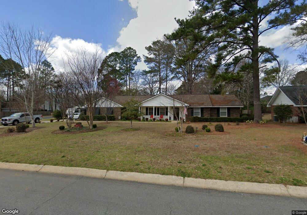
This home is located at 2011 Northside Rd, Perry, GA 31069 and is currently estimated at $283,125, approximately $132 per square foot. 2011 Northside Rd is a home located in Houston County with nearby schools including Morningside Elementary School, Perry Middle School, and Perry High School.
Ownership History
Date
Name
Owned For
Owner Type
Purchase Details
Closed on
Oct 26, 2015
Sold by
Dawkins Gillis R
Bought by
Moulliet Gary J and Moulliet Charlene B
Current Estimated Value
Home Financials for this Owner
Home Financials are based on the most recent Mortgage that was taken out on this home.
Original Mortgage
$125,000
Outstanding Balance
$97,024
Interest Rate
3.89%
Mortgage Type
VA
Estimated Equity
$186,101
Purchase Details
Closed on
Apr 30, 1990
Sold by
O'Neal Randy D and Linda L*
Bought by
Dawkins Gillis R and Dawkins Betty C
Purchase Details
Closed on
Jul 5, 1988
Sold by
Haukebo Kevin P and April C*
Bought by
O'Neal Randy D and Linda L*
Purchase Details
Closed on
Jun 30, 1986
Sold by
Whitney Harold R and Patsy P*
Bought by
Haukebo Kevin P and April C*
Purchase Details
Closed on
Feb 12, 1983
Sold by
Barfield Gilbert and Elaine D*
Bought by
Whitney Harold R and Patsy P*
Purchase Details
Closed on
Oct 30, 1979
Sold by
Mullins W G
Bought by
Barfield Gilbert and Elaine D*
Purchase Details
Closed on
Oct 8, 1973
Sold by
Security Services Inc
Bought by
Mullins W G
Purchase Details
Closed on
Feb 22, 1973
Sold by
Culpepper Charles F Etal
Bought by
Security Services Inc
Create a Home Valuation Report for This Property
The Home Valuation Report is an in-depth analysis detailing your home's value as well as a comparison with similar homes in the area
Home Values in the Area
Average Home Value in this Area
Purchase History
| Date | Buyer | Sale Price | Title Company |
|---|---|---|---|
| Moulliet Gary J | $125,000 | -- | |
| Dawkins Gillis R | -- | -- | |
| O'Neal Randy D | -- | -- | |
| Haukebo Kevin P | -- | -- | |
| Whitney Harold R | -- | -- | |
| Barfield Gilbert | -- | -- | |
| Mullins W G | -- | -- | |
| Security Services Inc | -- | -- |
Source: Public Records
Mortgage History
| Date | Status | Borrower | Loan Amount |
|---|---|---|---|
| Open | Moulliet Gary J | $125,000 |
Source: Public Records
Tax History
| Year | Tax Paid | Tax Assessment Tax Assessment Total Assessment is a certain percentage of the fair market value that is determined by local assessors to be the total taxable value of land and additions on the property. | Land | Improvement |
|---|---|---|---|---|
| 2025 | -- | $86,640 | $9,800 | $76,840 |
| 2024 | -- | $83,960 | $10,760 | $73,200 |
| 2023 | $0 | $69,720 | $10,760 | $58,960 |
| 2022 | $2,366 | $63,960 | $10,760 | $53,200 |
| 2021 | $2,104 | $56,360 | $10,760 | $45,600 |
| 2020 | $1,951 | $52,240 | $10,760 | $41,480 |
| 2019 | $1,214 | $52,240 | $10,760 | $41,480 |
| 2018 | $1,214 | $52,240 | $10,760 | $41,480 |
| 2017 | $1,215 | $52,240 | $10,760 | $41,480 |
| 2016 | $1,164 | $57,200 | $10,760 | $46,440 |
| 2015 | $1,119 | $57,200 | $10,760 | $46,440 |
| 2014 | -- | $57,200 | $10,760 | $46,440 |
| 2013 | -- | $57,240 | $10,760 | $46,480 |
Source: Public Records
Map
Nearby Homes
- 110 Gwendolyn Ave
- 1015 Cherokee Rd
- 206 Londie Ln
- 206 Londe Ln
- 102 Ridge Cir N
- 108 Christine Cir
- 102 N Haven Ln
- 115 Springfield Ct
- 111 Tyndall Way
- 105 Eagles Ridge Ct
- 1402 Park Ave
- 106 Raspberry Trail
- 101 Lighterknot Trail
- 204 Spring Creek Dr
- 103 Kanza Trail
- 109 Kanza Trail
- 108 Ousley Way
- 118 Farmers Way
- 112 Bainbridge Ln
- 1418 Parkway Dr
- 2013 Northside Rd
- 300 Cedar Ridge Dr
- 2009 Cedar Ridge Dr
- 2023 Northside Rd
- 2015 Northside Rd
- 1921 Northside Rd
- 301 Cedar Ridge Dr
- 302 Wind River Dr
- 2012 Northside Rd
- 422 N Legacy Park Dr
- 2008 Cedar Ridge Dr
- 1919 Northside Rd
- 420 Legacy Park Dr
- 2014 Laurel Dr
- 2007 Cedar Ridge Dr
- 2025 Northside Rd
- 206 Cedar Ridge Dr
- 426 Legacy Park Dr
- 1926 Northside Rd
- 214 Windermere Dr
Your Personal Tour Guide
Ask me questions while you tour the home.