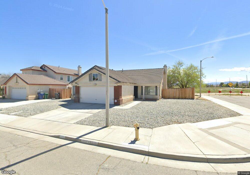
2012 Ogden Ln Lancaster, CA 93535
East Lancaster NeighborhoodEstimated Value: $417,572 - $462,000
3
Beds
2
Baths
1,583
Sq Ft
$277/Sq Ft
Est. Value
About This Home
This home is located at 2012 Ogden Ln, Lancaster, CA 93535 and is currently estimated at $438,643, approximately $277 per square foot. 2012 Ogden Ln is a home located in Los Angeles County with nearby schools including Eastside Elementary School, Gifford C. Cole Middle School, and Eastside High School.
Ownership History
Date
Name
Owned For
Owner Type
Purchase Details
Closed on
Jan 18, 1996
Sold by
West Venture
Bought by
Clark Thomas R
Current Estimated Value
Home Financials for this Owner
Home Financials are based on the most recent Mortgage that was taken out on this home.
Original Mortgage
$115,249
Interest Rate
7.34%
Mortgage Type
VA
Create a Home Valuation Report for This Property
The Home Valuation Report is an in-depth analysis detailing your home's value as well as a comparison with similar homes in the area
Home Values in the Area
Average Home Value in this Area
Purchase History
| Date | Buyer | Sale Price | Title Company |
|---|---|---|---|
| Clark Thomas R | $113,000 | Continental Lawyers Title Co |
Source: Public Records
Mortgage History
| Date | Status | Borrower | Loan Amount |
|---|---|---|---|
| Previous Owner | Clark Thomas R | $115,249 |
Source: Public Records
Tax History
| Year | Tax Paid | Tax Assessment Tax Assessment Total Assessment is a certain percentage of the fair market value that is determined by local assessors to be the total taxable value of land and additions on the property. | Land | Improvement |
|---|---|---|---|---|
| 2025 | $3,544 | $187,692 | $29,888 | $157,804 |
| 2024 | $3,544 | $184,012 | $29,302 | $154,710 |
| 2023 | $3,441 | $180,405 | $28,728 | $151,677 |
| 2022 | $3,303 | $176,868 | $28,165 | $148,703 |
| 2021 | $2,946 | $173,401 | $27,613 | $145,788 |
| 2019 | $2,887 | $168,260 | $26,795 | $141,465 |
| 2018 | $2,839 | $164,962 | $26,270 | $138,692 |
| 2016 | $2,713 | $158,557 | $25,250 | $133,307 |
| 2015 | $2,677 | $156,176 | $24,871 | $131,305 |
| 2014 | $2,574 | $144,000 | $22,900 | $121,100 |
Source: Public Records
Map
Nearby Homes
- 43525 Palos Way
- 0 St Unit 26002646
- 43527 Grange St
- 1848 Trudgeon Ave
- 43635 Castle Cir
- 43709 Castle Cir
- 43625 Ponderosa St
- 43659 Ponderosa St
- 2203 Rosewood Ave
- 1554 Granville Way
- 2303 Rosewood Ave
- 43850 20th St E Unit 83
- 43850 20th St E Unit 265
- 43850 20th St E Unit Spc 114
- 43850 20th St E Unit 88
- 0 E Avenue K 8 Unit SR25104679
- 0 E Avenue K 8 Unit 25005911
- 1642 Bisbee Place
- 43711 16th St E
- 1519 Michelle Ave
- 2018 Ogden Ln
- 2024 Ogden Ln
- 0 E 20th St & Ave Unit 246235
- 0 E 20th St & Ave Unit 288375
- 0 E 20th St & Ave Unit 1203031
- 0 E 20th St & Ave Unit K-10 1300896
- 0 E 20th St & Ave Unit K-4 1205866
- 43449 Huron St
- 2011 Ogden Ln
- 43455 Huron St
- 2019 Ogden Ln
- 43461 Huron St
- 2032 Ogden Ln
- 43503 Huron St
- 2035 Ogden Ln
- 2040 Ogden Ln
- 43509 Palos Way
- 43452 Palos Way
- 43517 Palos Way
- 43460 Palos Way
Your Personal Tour Guide
Ask me questions while you tour the home.