Estimated Value: $264,980 - $362,000
4
Beds
2
Baths
2,098
Sq Ft
$142/Sq Ft
Est. Value
About This Home
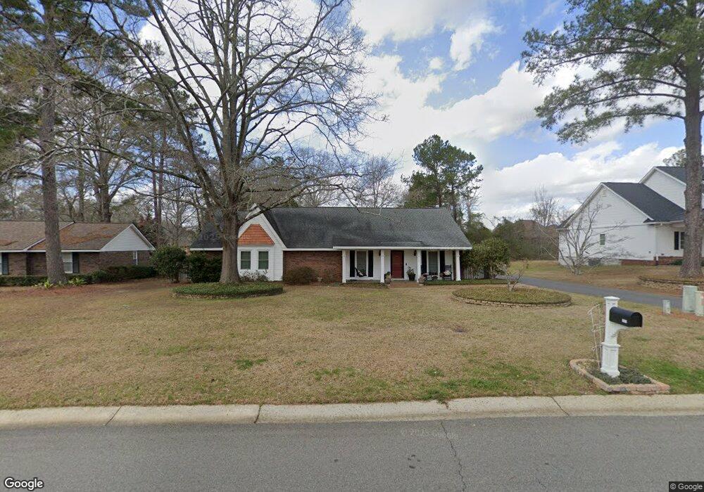
This home is located at 2013 Northside Rd, Perry, GA 31069 and is currently estimated at $297,495, approximately $141 per square foot. 2013 Northside Rd is a home located in Houston County with nearby schools including Morningside Elementary School, Perry Middle School, and Perry High School.
Ownership History
Date
Name
Owned For
Owner Type
Purchase Details
Closed on
Mar 26, 2018
Sold by
Forest Hill Property Llc
Bought by
Turner Robert E and Turner Amy E
Current Estimated Value
Purchase Details
Closed on
Sep 2, 1993
Sold by
Langston James C and Gale E*
Bought by
Turner Robert E and Amy E*
Purchase Details
Closed on
Jan 22, 1990
Sold by
Roberts A Roy
Bought by
Langston James C and Gale E*
Purchase Details
Closed on
Mar 2, 1988
Sold by
Brown-Forman Corp
Bought by
Roberts A Roy
Purchase Details
Closed on
Oct 22, 1987
Sold by
Colvin Carl R and Colvin Trucy B
Bought by
Brown-Forman Corp
Purchase Details
Closed on
Jul 18, 1979
Sold by
Culpepper Charles F and Culpepper Wingfiel
Bought by
Colvin Carl R and Colvin Trucy B
Purchase Details
Closed on
Feb 12, 1979
Sold by
500 Inc
Bought by
Culpepper Charles F and Wingfield Joh
Create a Home Valuation Report for This Property
The Home Valuation Report is an in-depth analysis detailing your home's value as well as a comparison with similar homes in the area
Home Values in the Area
Average Home Value in this Area
Purchase History
| Date | Buyer | Sale Price | Title Company |
|---|---|---|---|
| Turner Robert E | $1,500 | None Available | |
| Turner Robert E | $86,800 | -- | |
| Langston James C | -- | -- | |
| Roberts A Roy | -- | -- | |
| Brown-Forman Corp | -- | -- | |
| Colvin Carl R | -- | -- | |
| Culpepper Charles F | -- | -- |
Source: Public Records
Tax History Compared to Growth
Tax History
| Year | Tax Paid | Tax Assessment Tax Assessment Total Assessment is a certain percentage of the fair market value that is determined by local assessors to be the total taxable value of land and additions on the property. | Land | Improvement |
|---|---|---|---|---|
| 2024 | $3,082 | $85,120 | $8,480 | $76,640 |
| 2023 | $2,575 | $70,840 | $8,480 | $62,360 |
| 2022 | $1,421 | $63,800 | $8,480 | $55,320 |
| 2021 | $1,247 | $55,920 | $8,480 | $47,440 |
| 2020 | $1,163 | $52,080 | $8,480 | $43,600 |
| 2019 | $1,163 | $52,080 | $8,480 | $43,600 |
| 2018 | $1,146 | $51,320 | $7,720 | $43,600 |
| 2017 | $1,147 | $51,320 | $7,720 | $43,600 |
| 2016 | $1,149 | $51,320 | $7,720 | $43,600 |
| 2015 | $1,151 | $51,320 | $7,720 | $43,600 |
| 2014 | -- | $51,320 | $7,720 | $43,600 |
| 2013 | -- | $51,320 | $7,720 | $43,600 |
Source: Public Records
Map
Nearby Homes
- 412 Legacy Park Dr
- 500 Legacy Park Dr
- 110 Gwendolyn Ave
- 1015 Cherokee Rd
- 314 Waxmyrtle Way
- 204 Susanne's Retreat
- 102 Seven Pines Ct
- 1008 Ridge Cir S
- 102 N Haven Ln
- 108 Christine Cir
- 107 Lighterknot Trail
- 106 Raspberry Trail
- 1402 Park Ave
- 311 Rusty Plow Ln
- 307 Rusty Plow Ln
- 104 Red Barn Ct
- 102 Kanza Trail
- 118 Farmers Way
- 113 Flat Rock Ln
- 100 Flat Rock Ln
- 2023 Northside Rd
- 2015 Northside Rd
- 2011 Northside Rd
- 300 Cedar Ridge Dr
- 2009 Cedar Ridge Dr
- 2012 Northside Rd
- 2025 Northside Rd
- 422 N Legacy Park Dr
- 420 Legacy Park Dr
- 2014 Laurel Dr
- 426 Legacy Park Dr
- 302 Wind River Dr
- 2007 Cedar Ridge Dr
- 1921 Northside Rd
- 301 Cedar Ridge Dr
- 418 Legacy Park Dr
- 2016 Laurel Dr
- 2027 Northside Rd
- 428 Legacy Park Dr
- 206 Cedar Ridge Dr