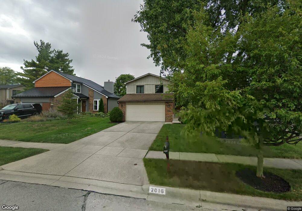
2016 Sutter Pkwy Dublin, OH 43016
Olde Sawmill NeighborhoodEstimated Value: $354,354 - $422,000
3
Beds
3
Baths
1,522
Sq Ft
$258/Sq Ft
Est. Value
About This Home
This home is located at 2016 Sutter Pkwy, Dublin, OH 43016 and is currently estimated at $393,339, approximately $258 per square foot. 2016 Sutter Pkwy is a home located in Franklin County with nearby schools including Granby Elementary School, McCord Middle School, and Worthington Kilbourne High School.
Ownership History
Date
Name
Owned For
Owner Type
Purchase Details
Closed on
May 2, 2005
Sold by
Maghes Charles T and Maghes Michelle C
Bought by
Helf Brett C and Helf Wendy L
Current Estimated Value
Purchase Details
Closed on
Jun 18, 1999
Sold by
Hughes Walter E and Hughes Margaret A
Bought by
Maghes Charles T and Maghes Michelle C
Purchase Details
Closed on
Jul 25, 1986
Bought by
Hughes Walter E
Purchase Details
Closed on
Dec 1, 1985
Create a Home Valuation Report for This Property
The Home Valuation Report is an in-depth analysis detailing your home's value as well as a comparison with similar homes in the area
Home Values in the Area
Average Home Value in this Area
Purchase History
| Date | Buyer | Sale Price | Title Company |
|---|---|---|---|
| Helf Brett C | $183,000 | Title First | |
| Helf Brett C | $183,000 | Title First | |
| Maghes Charles T | $133,000 | Franklin Abstract | |
| Maghes Charles T | $133,000 | Franklin Abstract | |
| Hughes Walter E | $81,700 | -- | |
| Hughes Walter E | $81,700 | -- | |
| -- | $26,500 | -- | |
| -- | $26,500 | -- |
Source: Public Records
Tax History
| Year | Tax Paid | Tax Assessment Tax Assessment Total Assessment is a certain percentage of the fair market value that is determined by local assessors to be the total taxable value of land and additions on the property. | Land | Improvement |
|---|---|---|---|---|
| 2025 | $5,959 | $97,060 | $31,850 | $65,210 |
| 2024 | $5,959 | $97,060 | $31,850 | $65,210 |
| 2023 | $5,698 | $97,060 | $31,850 | $65,210 |
| 2022 | $4,638 | $62,690 | $14,740 | $47,950 |
| 2021 | $4,279 | $62,690 | $14,740 | $47,950 |
| 2020 | $4,122 | $62,690 | $14,740 | $47,950 |
| 2019 | $3,775 | $51,810 | $12,290 | $39,520 |
| 2018 | $3,860 | $51,810 | $12,290 | $39,520 |
| 2017 | $3,723 | $51,810 | $12,290 | $39,520 |
| 2016 | $4,063 | $57,230 | $15,020 | $42,210 |
| 2015 | $4,064 | $57,230 | $15,020 | $42,210 |
| 2014 | $4,062 | $57,230 | $15,020 | $42,210 |
| 2013 | $2,021 | $57,225 | $15,015 | $42,210 |
Source: Public Records
Map
Nearby Homes
- 1986 Sutter Pkwy
- 2074 Hard Rd
- 7746 Sagemeadow Ct
- 1908 Lost Valley Rd
- 2001 Sawbury Blvd Unit 2001
- 8205 Longhorn Rd
- 7898 Sarahurst Dr
- 1967 Slaton Ct
- 7907 Sarahurst Dr
- 2423 Sutter Pkwy
- 2456 Sanford Dr
- 1930 Shallowford Ave
- 2469 Sandstrom Dr
- 1539 Clubview Blvd S
- 2475 Slateshire Dr
- 7034 Rockhaven Place
- 2208 Otter Ln
- 8622 Renford Ct
- 2161 Heatherfield Ave
- 7456 Mapleleaf Ct
- 2024 Sutter Pkwy
- 2008 Sutter Pkwy
- 2000 Sutter Pkwy
- 1988 Stancrest Rd
- 1994 Stancrest Rd
- 2015 Shadeview Ct
- 2023 Shadeview Ct
- 2007 Shadeview Ct
- 1992 Sutter Pkwy
- 2013 Sutter Pkwy
- 2005 Sutter Pkwy
- 2031 Shadeview Ct
- 2029 Sutter Pkwy
- 1999 Shadeview Ct
- 2037 Sutter Pkwy
- 1989 Sutter Pkwy
- 1980 Sutter Pkwy
- 1991 Shadeview Ct
- 1983 Sutter Pkwy
- 2045 Sutter Pkwy