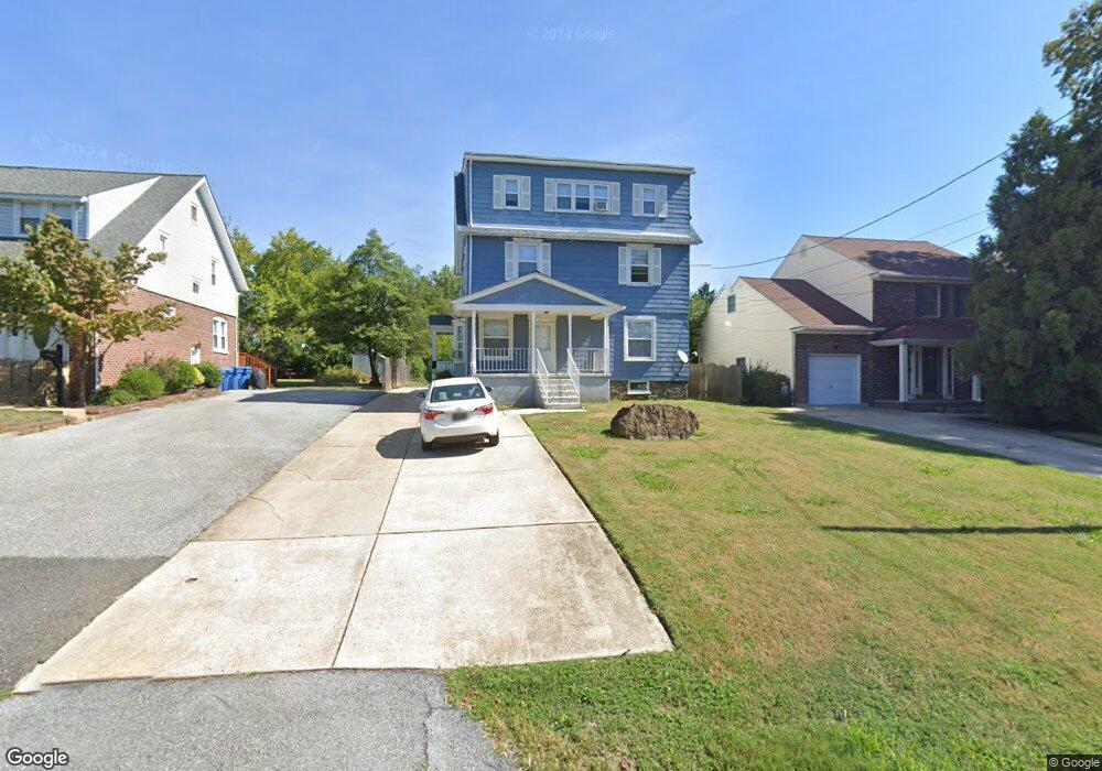
203 Lore Ave Wilmington, DE 19809
Estimated Value: $394,000 - $562,000
5
Beds
3
Baths
2,708
Sq Ft
$177/Sq Ft
Est. Value
About This Home
This home is located at 203 Lore Ave, Wilmington, DE 19809 and is currently estimated at $478,000, approximately $176 per square foot. 203 Lore Ave is a home located in New Castle County with nearby schools including Mount Pleasant Elementary School, Pierre S. Dupont Middle School, and Mount Pleasant High School.
Ownership History
Date
Name
Owned For
Owner Type
Purchase Details
Closed on
Apr 12, 2024
Sold by
Widdoes Denise
Bought by
Widdoes Michael J
Current Estimated Value
Purchase Details
Closed on
Apr 5, 2024
Sold by
Widdoes Michael J
Bought by
Moxie Widdoes Holding Llc
Purchase Details
Closed on
Dec 7, 1996
Bought by
Widdoes Denise B & Baraba Emil D Trust
Create a Home Valuation Report for This Property
The Home Valuation Report is an in-depth analysis detailing your home's value as well as a comparison with similar homes in the area
Home Values in the Area
Average Home Value in this Area
Purchase History
| Date | Buyer | Sale Price | Title Company |
|---|---|---|---|
| Widdoes Michael J | -- | None Listed On Document | |
| Widdoes Michael J | -- | None Listed On Document | |
| Widdoes Denise | -- | None Listed On Document | |
| Widdoes Denise | -- | None Listed On Document | |
| Moxie Widdoes Holding Llc | -- | None Listed On Document | |
| Moxie Widdoes Holding Llc | -- | None Listed On Document | |
| Widdoes Denise B & Baraba Emil D Trust | -- | -- |
Source: Public Records
Tax History Compared to Growth
Tax History
| Year | Tax Paid | Tax Assessment Tax Assessment Total Assessment is a certain percentage of the fair market value that is determined by local assessors to be the total taxable value of land and additions on the property. | Land | Improvement |
|---|---|---|---|---|
| 2024 | $2,592 | $66,400 | $9,900 | $56,500 |
| 2023 | $2,375 | $66,400 | $9,900 | $56,500 |
| 2022 | $2,403 | $66,400 | $9,900 | $56,500 |
| 2021 | $2,402 | $66,400 | $9,900 | $56,500 |
| 2020 | $2,401 | $66,400 | $9,900 | $56,500 |
| 2019 | $2,832 | $66,400 | $9,900 | $56,500 |
| 2018 | $2,297 | $66,400 | $9,900 | $56,500 |
| 2017 | $2,263 | $66,400 | $9,900 | $56,500 |
| 2016 | $2,257 | $66,400 | $9,900 | $56,500 |
| 2015 | $2,080 | $66,400 | $9,900 | $56,500 |
| 2014 | $2,079 | $66,400 | $9,900 | $56,500 |
Source: Public Records
Map
Nearby Homes
- 304 Chestnut Ave
- 705 Phillips Ave
- 402 Grove Ave
- 5 Blue Rock Rd
- 1107 Haines Ave
- 8506 Park Ct Unit 8506
- 47 N Pennewell Dr
- 18 S Pennewell Dr
- 2212 Heather Ct Unit 2212
- 302 River Rd Unit D8
- 6201 Highland Ct Unit 6201
- 1100 Lore Ave Unit 509
- 1103 Melrose Ave
- 1213 Talley Rd
- 17 S Rodney Dr
- 607 Brighton Rd
- 4304 N Pine St
- 109 E 40th St
- 5207 Le Parc Dr Unit 8
- 0 Bell Hill Rd