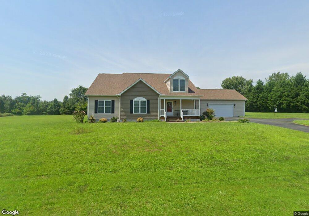
204 Sycamore Ln Townsend, DE 19734
Estimated Value: $522,880 - $574,000
3
Beds
2
Baths
2,296
Sq Ft
$240/Sq Ft
Est. Value
About This Home
This home is located at 204 Sycamore Ln, Townsend, DE 19734 and is currently estimated at $550,220, approximately $239 per square foot. 204 Sycamore Ln is a home located in New Castle County with nearby schools including Old State Elementary School, Cantwell's Bridge Middle School, and Odessa High School.
Ownership History
Date
Name
Owned For
Owner Type
Purchase Details
Closed on
Jul 1, 2024
Sold by
Revocable Trust Of Almarie C Laird and Laird Linda
Bought by
Laird Linda
Current Estimated Value
Purchase Details
Closed on
Dec 6, 2017
Sold by
Laird Almarie C
Bought by
Laird Almarie C and Revocable Trust Of Almarie C Laird
Purchase Details
Closed on
Jun 30, 2011
Sold by
Wright Mashall
Bought by
Laird Almarie C
Purchase Details
Closed on
Feb 25, 2005
Sold by
Kushela Nancy L and Kushela Rodman L
Bought by
Wright Marshall
Home Financials for this Owner
Home Financials are based on the most recent Mortgage that was taken out on this home.
Original Mortgage
$135,000
Interest Rate
5.64%
Mortgage Type
Unknown
Create a Home Valuation Report for This Property
The Home Valuation Report is an in-depth analysis detailing your home's value as well as a comparison with similar homes in the area
Home Values in the Area
Average Home Value in this Area
Purchase History
| Date | Buyer | Sale Price | Title Company |
|---|---|---|---|
| Laird Linda | -- | None Listed On Document | |
| Laird Almarie C | -- | None Available | |
| Laird Almarie C | -- | None Available | |
| Laird Almarie C | $90,000 | None Available | |
| Wright Marshall | $150,000 | -- |
Source: Public Records
Mortgage History
| Date | Status | Borrower | Loan Amount |
|---|---|---|---|
| Previous Owner | Wright Marshall | $135,000 |
Source: Public Records
Tax History Compared to Growth
Tax History
| Year | Tax Paid | Tax Assessment Tax Assessment Total Assessment is a certain percentage of the fair market value that is determined by local assessors to be the total taxable value of land and additions on the property. | Land | Improvement |
|---|---|---|---|---|
| 2024 | $1,636 | $86,600 | $9,700 | $76,900 |
| 2023 | $186 | $86,600 | $9,700 | $76,900 |
| 2022 | $1,307 | $86,600 | $9,700 | $76,900 |
| 2021 | $1,383 | $86,600 | $9,700 | $76,900 |
| 2020 | $1,361 | $86,600 | $9,700 | $76,900 |
| 2019 | $1,220 | $86,600 | $9,700 | $76,900 |
| 2018 | $1,163 | $86,600 | $9,700 | $76,900 |
| 2017 | $1,100 | $86,600 | $9,700 | $76,900 |
| 2016 | $859 | $86,600 | $9,700 | $76,900 |
| 2015 | $834 | $86,600 | $9,700 | $76,900 |
| 2014 | -- | $86,600 | $9,700 | $76,900 |
Source: Public Records
Map
Nearby Homes
- 1143 Kayla Ln
- 1020 Robinson Rd
- 1019 Robinson Rd
- 1027 Robinson Rd
- 214 Abbigail Crossing
- 1113 Kayla Ln
- 1060 Robinson Rd Unit WHITFIELD PLAN
- 1062 Robinson Rd Unit WHITFIELD RANCH PLAN
- 1064 Robinson Rd Unit LAKELAND PLAN
- 1066 Robinson Rd Unit PEMBROOK PLAN
- 1068 Robinson Rd Unit DELRAY PLAN
- 604 Ravenglass Dr
- 214 Case Rd
- 212 Case Rd
- 1529 Paige Place
- 1531 Paige Place
- 210 Case Rd
- 101 Wedge Ct
- 506 Aviemore Dr
- 660 Courtly Rd