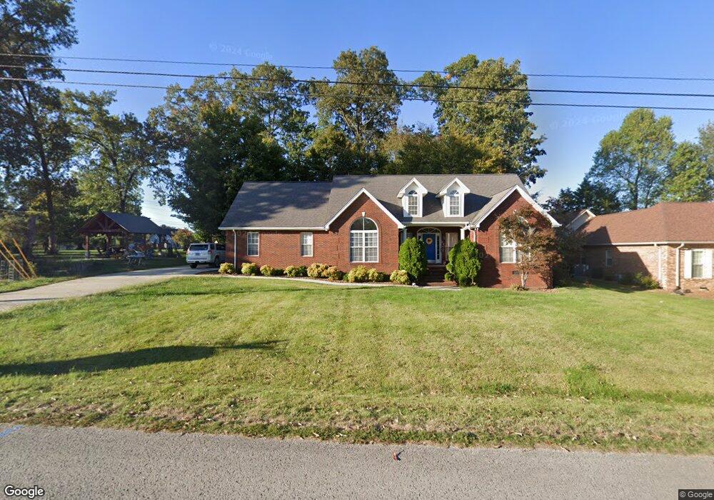
206 Brookside Dr Cookeville, TN 38506
Estimated Value: $406,142 - $495,000
--
Bed
3
Baths
2,290
Sq Ft
$195/Sq Ft
Est. Value
About This Home
This home is located at 206 Brookside Dr, Cookeville, TN 38506 and is currently estimated at $445,536, approximately $194 per square foot. 206 Brookside Dr is a home located in Putnam County with nearby schools including Algood Middle School, Algood Elementary School, and Cookeville High School.
Ownership History
Date
Name
Owned For
Owner Type
Purchase Details
Closed on
Dec 18, 2003
Sold by
Burgess Family Partnership
Bought by
Deweese Clint T and Deweese Jody M
Current Estimated Value
Home Financials for this Owner
Home Financials are based on the most recent Mortgage that was taken out on this home.
Original Mortgage
$162,350
Outstanding Balance
$76,122
Interest Rate
6.05%
Estimated Equity
$369,414
Purchase Details
Closed on
Apr 30, 2001
Bought by
Burgess Family Partnership
Purchase Details
Closed on
Aug 26, 1987
Bought by
Greenwood Sallie May William D Clar
Purchase Details
Closed on
Nov 19, 1924
Bought by
Greenwood Sallie May William D Clar
Create a Home Valuation Report for This Property
The Home Valuation Report is an in-depth analysis detailing your home's value as well as a comparison with similar homes in the area
Home Values in the Area
Average Home Value in this Area
Purchase History
| Date | Buyer | Sale Price | Title Company |
|---|---|---|---|
| Deweese Clint T | $21,000 | -- | |
| Burgess Family Partnership | $450,000 | -- | |
| Greenwood Sallie May William D Clar | -- | -- | |
| Greenwood Sallie May William D Clar | -- | -- |
Source: Public Records
Mortgage History
| Date | Status | Borrower | Loan Amount |
|---|---|---|---|
| Open | Greenwood Sallie May William D Clar | $162,350 |
Source: Public Records
Tax History Compared to Growth
Tax History
| Year | Tax Paid | Tax Assessment Tax Assessment Total Assessment is a certain percentage of the fair market value that is determined by local assessors to be the total taxable value of land and additions on the property. | Land | Improvement |
|---|---|---|---|---|
| 2024 | $1,963 | $73,800 | $8,750 | $65,050 |
| 2023 | $1,963 | $73,800 | $8,750 | $65,050 |
| 2022 | $1,824 | $73,800 | $8,750 | $65,050 |
| 2021 | $2,092 | $73,800 | $8,750 | $65,050 |
| 2020 | $1,833 | $73,800 | $8,750 | $65,050 |
| 2019 | $2,109 | $62,650 | $7,500 | $55,150 |
| 2018 | $2,016 | $62,650 | $7,500 | $55,150 |
| 2017 | $2,016 | $62,650 | $7,500 | $55,150 |
| 2016 | $2,031 | $62,650 | $7,500 | $55,150 |
| 2015 | $2,078 | $62,650 | $7,500 | $55,150 |
| 2014 | $2,021 | $60,913 | $0 | $0 |
Source: Public Records
Map
Nearby Homes
- 372 Brookside Dr
- 292 Williams Cir
- 251 Haven Ln
- 146 Dry Valley Rd
- 114 Thompson Ln
- 152 Lane Ave
- 2818 Oak Haven Place
- 164 W Wall St
- 3382 Norfolk Dr
- 136 Phillips Bend Ct
- 0 Burton Cove Rd
- 88 Quinland Lake Rd
- 3516 Heritage Green Way
- 3524 Heritage Green Way
- 1799 Fairway Dr
- 3447 Shenandoah Ln
- 936 N Plantation Dr
- 250 E Main East St
- 250 E Main St
- 212 Brookside Dr
- 205 Brookside Dr
- 209 Brookside Dr
- 213 Brookside Dr
- 201 Brookside Dr
- 224 Brookside Dr
- 294 Dry Valley Rd
- 219 Brookside Dr
- 303 Dry Valley Rd
- 385 Brookside Dr
- 389 Brookside Dr
- 379 Brookside Dr
- 321 Dry Valley Rd
- 230 Brookside Dr
- 375 Brookside Dr
- 395 Brookside Dr
- 225 Brookside Dr
- 10 AC Dry Valley Rd
- 8 Acres Dry Valley Rd
- LOT 4 Dry Valley Rd