2065 Acwron Dr Red Bluff, CA 96080
Red Bluff AreaEstimated Value: $290,000 - $326,000
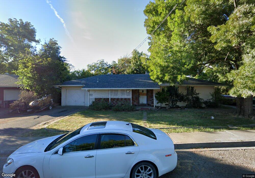
About This Home
This home is located at 2065 Acwron Dr, Red Bluff, CA 96080 and is currently estimated at $305,887, approximately $219 per square foot. 2065 Acwron Dr is a home located in Tehama County with nearby schools including Bidwell Elementary School, Vista Preparatory Academy, and Red Bluff High School.
Ownership History
We collect this data history from publicly available records. To have your information removed, we recommend requesting removal directly through your county’s website.
Purchase Details
Purchase Details
Home Financials for this Owner
Home Financials are based on the most recent Mortgage that was taken out on this home.Purchase Details
Purchase History
We collect this data history from publicly available records. To have your information removed, we recommend requesting removal directly through your county’s website.
| Date | Buyer | Sale Price | Title Company |
|---|---|---|---|
| -- | None Available | ||
| $116,000 | Chicago Title Co | ||
| -- | -- |
Mortgage History
We collect this data history from publicly available records. To have your information removed, we recommend requesting removal directly through your county’s website.
| Date | Status | Borrower | Loan Amount |
|---|---|---|---|
| Open | $53,000 | ||
| Closed | $42,900 | ||
| Open | $92,720 |
Tax History
We collect this data history from publicly available records. To have your information removed, we recommend requesting removal directly through your county’s website.
| Year | Tax Paid | Tax Assessment Tax Assessment Total Assessment is a certain percentage of the fair market value that is determined by local assessors to be the total taxable value of land and additions on the property. | Land | Improvement |
|---|---|---|---|---|
| 2025 | $1,708 | $167,852 | $50,687 | $117,165 |
| 2023 | $1,679 | $161,336 | $48,720 | $112,616 |
| 2022 | $1,668 | $158,173 | $47,765 | $110,408 |
| 2021 | $1,601 | $155,073 | $46,829 | $108,244 |
| 2020 | $1,635 | $153,484 | $46,349 | $107,135 |
| 2019 | $1,574 | $143,937 | $43,467 | $100,470 |
| 2018 | $1,350 | $130,851 | $39,515 | $91,336 |
| 2017 | $1,264 | $118,956 | $35,923 | $83,033 |
| 2016 | $1,147 | $113,291 | $34,212 | $79,079 |
| 2015 | $1,146 | $113,291 | $34,212 | $79,079 |
| 2014 | $1,003 | $98,515 | $29,750 | $68,765 |
Map
- 2085 Acwron Dr
- 310 Michael Dr
- 379 Michael Dr
- 329 Michael Dr
- 550 Bayles Ave
- 490 Springtime Ln
- 1455 Acacia St
- 1555 Acacia St
- 1440 Robinson Dr
- 1560 Carl Ct
- 1450 Walnut St
- 12481 Paskenta Rd
- 1307 Deborah Dr
- 1520 Franzel Rd
- 1405 Robinson Dr
- 1335 Franzel Rd
- 1215 Wetter Way
- 1735 Douglass St
- 1039 1st St
- 1153 Cedar St
- 2075 Acwron Dr
- 2064 Stonybrook Dr
- 2060 Stonybrook Dr
- 2070 Acwron Dr
- 2055 Acwron Dr
- 2080 Acwron Dr
- 2066 Stonybrook Dr
- 2056 Stonybrook Dr
- 360 Michael Dr
- 370 Michael Dr
- 2060 Acwron Dr
- 350 Michael Dr
- 380 Michael Dr
- 2068 Stonybrook Dr
- 2045 Acwron Dr
- 340 Michael Dr
- 2050 Acwron Dr
- 2036 Stonybrook Dr
- 390 Michael Dr
- 2048 Stonybrook Dr
Ask me questions while you tour the home.