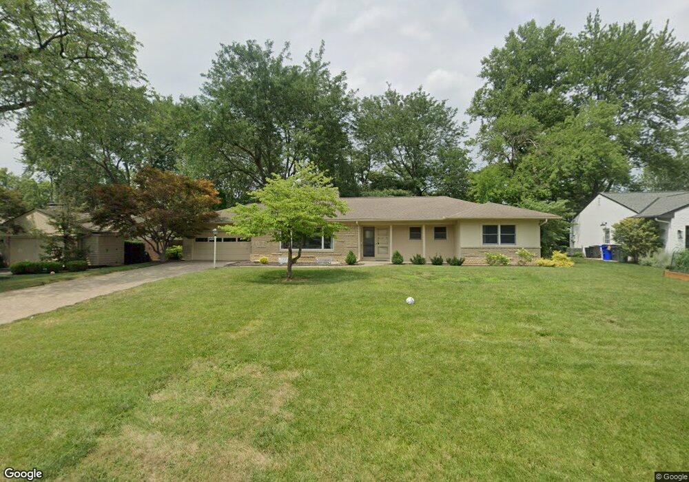
2078 Lytham Rd Columbus, OH 43220
Estimated Value: $522,194 - $622,000
3
Beds
2
Baths
1,572
Sq Ft
$369/Sq Ft
Est. Value
About This Home
This home is located at 2078 Lytham Rd, Columbus, OH 43220 and is currently estimated at $580,799, approximately $369 per square foot. 2078 Lytham Rd is a home located in Franklin County with nearby schools including Windermere Elementary School, Hastings Middle School, and Upper Arlington High School.
Ownership History
Date
Name
Owned For
Owner Type
Purchase Details
Closed on
Apr 1, 2024
Sold by
Slomczynski Kazimierz
Bought by
Slomczynski Kazimierz and Dubrow Irina
Current Estimated Value
Purchase Details
Closed on
Aug 4, 1993
Bought by
Slomczynski Kazimierz
Purchase Details
Closed on
May 1, 1986
Purchase Details
Closed on
Dec 1, 1980
Create a Home Valuation Report for This Property
The Home Valuation Report is an in-depth analysis detailing your home's value as well as a comparison with similar homes in the area
Home Values in the Area
Average Home Value in this Area
Purchase History
| Date | Buyer | Sale Price | Title Company |
|---|---|---|---|
| Slomczynski Kazimierz | -- | None Listed On Document | |
| Slomczynski Kazimierz | $144,900 | -- | |
| -- | $94,500 | -- | |
| -- | $76,500 | -- |
Source: Public Records
Tax History
| Year | Tax Paid | Tax Assessment Tax Assessment Total Assessment is a certain percentage of the fair market value that is determined by local assessors to be the total taxable value of land and additions on the property. | Land | Improvement |
|---|---|---|---|---|
| 2025 | $8,435 | $152,220 | $75,920 | $76,300 |
| 2024 | $8,435 | $152,220 | $75,920 | $76,300 |
| 2023 | $8,588 | $152,215 | $75,915 | $76,300 |
| 2022 | $7,240 | $112,360 | $54,430 | $57,930 |
| 2021 | $6,750 | $112,360 | $54,430 | $57,930 |
| 2020 | $6,502 | $112,360 | $54,430 | $57,930 |
| 2019 | $6,348 | $95,770 | $54,430 | $41,340 |
| 2018 | $3,000 | $95,770 | $54,430 | $41,340 |
| 2017 | $5,988 | $95,770 | $54,430 | $41,340 |
| 2016 | $5,418 | $90,690 | $35,250 | $55,440 |
| 2015 | $2,707 | $90,690 | $35,250 | $55,440 |
| 2014 | $5,419 | $90,690 | $35,250 | $55,440 |
| 2013 | $2,560 | $82,425 | $32,025 | $50,400 |
Source: Public Records
Map
Nearby Homes
- 4115 Woodbridge Rd
- 2255 Haviland Rd
- 3701 Reed Rd
- 2411 Lytham Rd
- 2413 Edgevale Rd
- 2458 Edgevale Rd
- 1811 Hove Rd
- 2480 Shrewsbury Rd
- 4545 Benderton Ct
- 1594 Lafayette Dr Unit 1594
- 1512 Lafayette Dr Unit B
- 2674 Woodstock Rd
- 1842 Ridgecliff Rd
- 1379 La Rochelle Dr Unit 19C
- 1744 Ridgecliff Rd Unit 12
- 3161 Avalon Rd
- 3175 Tremont Rd Unit 504
- 3175 Tremont Rd Unit 313
- 2227 Zollinger Rd
- 1530 Pemberton Dr
- 2066 Lytham Rd
- 2088 Lytham Rd
- 2069 Middlesex Rd
- 2057 Middlesex Rd
- 2085 Middlesex Rd
- 3936 Chevington Rd
- 3951 Mountview Rd
- 2100 Lytham Rd
- 3969 Mountview Rd
- 2095 Middlesex Rd
- 3929 Mountview Rd
- 2099 Lytham Rd
- 3922 Chevington Rd
- 2110 Lytham Rd
- 2107 Middlesex Rd
- 3915 Mountview Rd
- 2066 Middlesex Rd
- 3923 Chevington Rd
- 2080 Middlesex Rd
- 2056 Middlesex Rd