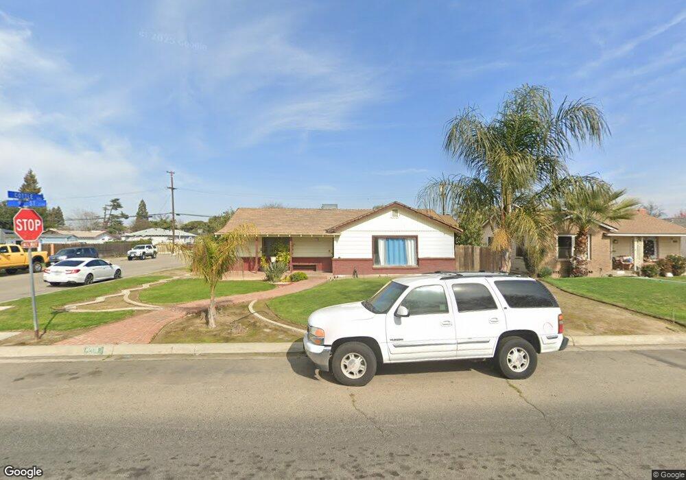
2118 9th St Sanger, CA 93657
Estimated Value: $358,000 - $380,431
3
Beds
2
Baths
1,637
Sq Ft
$225/Sq Ft
Est. Value
About This Home
This home is located at 2118 9th St, Sanger, CA 93657 and is currently estimated at $367,608, approximately $224 per square foot. 2118 9th St is a home located in Fresno County with nearby schools including Madison Elementary School, Washington Academic Middle School, and Sanger High School.
Ownership History
Date
Name
Owned For
Owner Type
Purchase Details
Closed on
Dec 1, 2005
Sold by
Ruiz Robert and Cabarrubias Bonnie
Bought by
Ruiz Robert
Current Estimated Value
Home Financials for this Owner
Home Financials are based on the most recent Mortgage that was taken out on this home.
Original Mortgage
$165,000
Outstanding Balance
$100,374
Interest Rate
7.8%
Mortgage Type
Purchase Money Mortgage
Estimated Equity
$267,234
Purchase Details
Closed on
Aug 15, 2000
Sold by
Swords Douglas R and Swords Carla A
Bought by
Kelly Lorita Rose
Home Financials for this Owner
Home Financials are based on the most recent Mortgage that was taken out on this home.
Original Mortgage
$85,500
Interest Rate
8.2%
Create a Home Valuation Report for This Property
The Home Valuation Report is an in-depth analysis detailing your home's value as well as a comparison with similar homes in the area
Home Values in the Area
Average Home Value in this Area
Purchase History
| Date | Buyer | Sale Price | Title Company |
|---|---|---|---|
| Ruiz Robert | -- | Fidelity National Title Co | |
| Kelly Lorita Rose | $95,000 | First American Title Co |
Source: Public Records
Mortgage History
| Date | Status | Borrower | Loan Amount |
|---|---|---|---|
| Open | Ruiz Robert | $165,000 | |
| Closed | Kelly Lorita Rose | $85,500 |
Source: Public Records
Tax History
| Year | Tax Paid | Tax Assessment Tax Assessment Total Assessment is a certain percentage of the fair market value that is determined by local assessors to be the total taxable value of land and additions on the property. | Land | Improvement |
|---|---|---|---|---|
| 2025 | $3,424 | $276,864 | $68,097 | $208,767 |
| 2023 | $3,202 | $266,114 | $65,453 | $200,661 |
| 2022 | $3,152 | $260,897 | $64,170 | $196,727 |
| 2021 | $3,125 | $255,782 | $62,912 | $192,870 |
| 2020 | $3,033 | $253,160 | $62,267 | $190,893 |
| 2019 | $2,970 | $248,197 | $61,047 | $187,150 |
| 2018 | $2,845 | $243,331 | $59,850 | $183,481 |
| 2017 | $2,795 | $238,561 | $58,677 | $179,884 |
| 2016 | $2,624 | $233,884 | $57,527 | $176,357 |
| 2015 | $2,645 | $230,371 | $56,663 | $173,708 |
| 2014 | $2,608 | $225,860 | $55,554 | $170,306 |
Source: Public Records
Map
Nearby Homes
- 1920 9th St
- 805 Lyon Ave
- 2129 Magnolia Ave
- 1745 N Bethel Ave
- 2599 Almond Ave
- 521 O St
- 2160 3rd St
- 1210 Sanger Ave
- 1377 Fenmore Ave
- 238 Fairbanks Ave
- 877 Sandra Ave
- 371 Bethel Ave Unit 74
- 371 Bethel Ave Unit 59
- 371 Bethel Ave
- 371 Bethel Ave Unit 24
- 371 Bethel Ave Unit 102
- 371 Bethel Ave Unit 27
- 912 L St
- 914 L St
- 720 L St
Your Personal Tour Guide
Ask me questions while you tour the home.