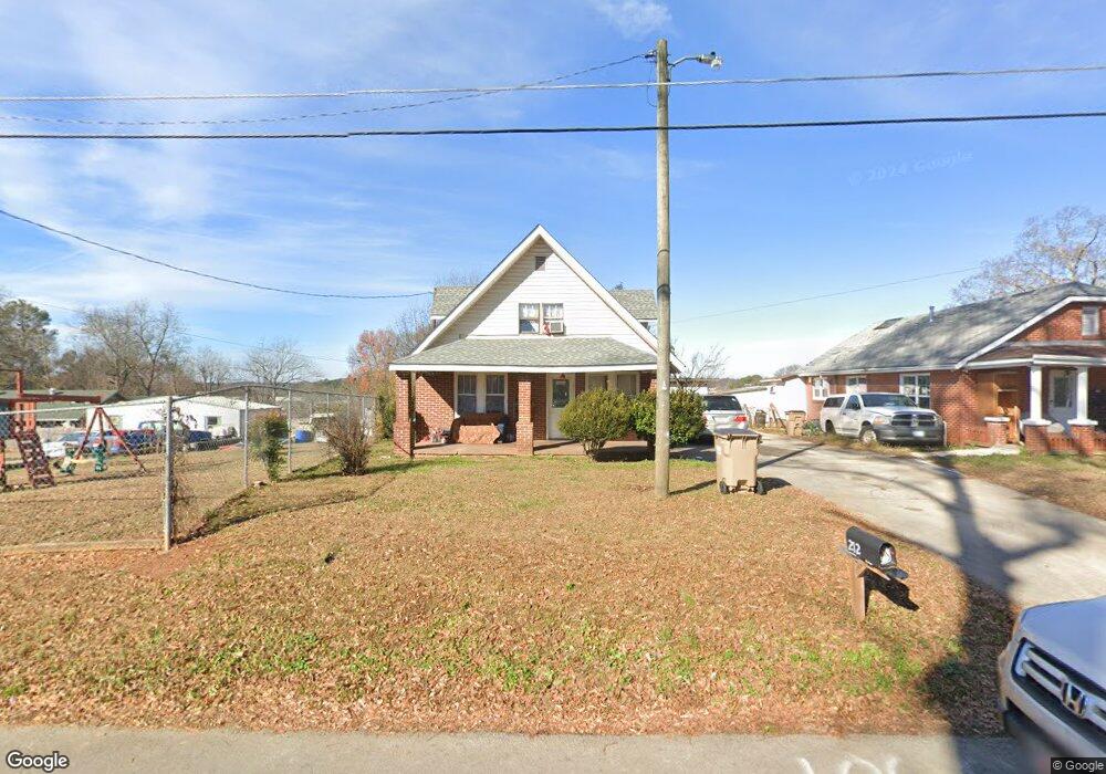
212 Stringer Ave Gainesville, GA 30501
West Side NeighborhoodEstimated Value: $168,000 - $300,000
5
Beds
2
Baths
1,630
Sq Ft
$148/Sq Ft
Est. Value
About This Home
This home is located at 212 Stringer Ave, Gainesville, GA 30501 and is currently estimated at $240,866, approximately $147 per square foot. 212 Stringer Ave is a home located in Hall County with nearby schools including Lyman Hall Elementary School, West Hall Middle School, and West Hall High School.
Ownership History
Date
Name
Owned For
Owner Type
Purchase Details
Closed on
Mar 28, 2017
Sold by
Hinshaw Nu Tara
Bought by
Hoang Trung Quoc
Current Estimated Value
Purchase Details
Closed on
Jan 21, 2013
Sold by
Nguyen Anh Thi
Bought by
Hinshaw Nu Tara
Purchase Details
Closed on
Aug 16, 1994
Sold by
Sexton Charles Joyce
Bought by
Nguyen Ninh Anh
Home Financials for this Owner
Home Financials are based on the most recent Mortgage that was taken out on this home.
Original Mortgage
$64,600
Interest Rate
8.65%
Create a Home Valuation Report for This Property
The Home Valuation Report is an in-depth analysis detailing your home's value as well as a comparison with similar homes in the area
Home Values in the Area
Average Home Value in this Area
Purchase History
| Date | Buyer | Sale Price | Title Company |
|---|---|---|---|
| Hoang Trung Quoc | $53,000 | -- | |
| Hinshaw Nu Tara | $20,000 | -- | |
| Nguyen Ninh Anh | $68,000 | -- |
Source: Public Records
Mortgage History
| Date | Status | Borrower | Loan Amount |
|---|---|---|---|
| Previous Owner | Nguyen Ninh Anh | $64,600 |
Source: Public Records
Tax History
| Year | Tax Paid | Tax Assessment Tax Assessment Total Assessment is a certain percentage of the fair market value that is determined by local assessors to be the total taxable value of land and additions on the property. | Land | Improvement |
|---|---|---|---|---|
| 2025 | $2,239 | $90,880 | $13,840 | $77,040 |
| 2024 | $1,753 | $68,000 | $13,840 | $54,160 |
| 2023 | $1,907 | $74,240 | $20,720 | $53,520 |
| 2022 | $1,139 | $41,360 | $10,760 | $30,600 |
| 2021 | $945 | $33,200 | $5,640 | $27,560 |
| 2020 | $930 | $31,680 | $5,640 | $26,040 |
| 2019 | $798 | $26,560 | $5,640 | $20,920 |
| 2018 | $672 | $23,160 | $4,920 | $18,240 |
| 2017 | $783 | $25,412 | $4,920 | $20,492 |
| 2016 | $765 | $25,412 | $4,920 | $20,492 |
| 2015 | $744 | $24,412 | $3,920 | $20,492 |
| 2014 | $744 | $24,412 | $3,920 | $20,492 |
Source: Public Records
Map
Nearby Homes
- 0 Hilton Dr Unit 10529633
- 1122 Villa Clara Way
- 1636 Atlanta Hwy
- 0 Hilton Southwest Dr Unit 7697592
- 4171 Millstone Park Ln
- 1639 Whiting Dr
- 593 Shallowford Rd NW
- 2054 Spring Rd
- 1255 Purina Dr
- 2147 Spring Rd
- 2244 Bennett Cir
- 2180 Spring Rd
- 25 Fourth St
- 19 Fourth St
- 2504 Browns Bridge Rd
- 221 Shallowford Dr
- 219 Shallowford Dr
- 2346 4th St
- 515 Nightfire Ct SW
- 510 Nightfire Ct SW
- 210 Stringer Ave
- 101 Frederick St
- 218 Stringer Ave
- 15 Mimosa St
- 103 Frederick St
- 9 Mimosa St
- 208 Stringer Ave
- 17 Mimosa St
- 100 Frederick St
- 306 Stringer Ave
- 301 Stringer Ave
- 104 Frederick St
- 14 Mimosa St
- 915 Atlanta Hwy
- 308 Stringer Ave
- 11 Mimosa St
- 105 Frederick St
- 1005 Atlanta Hwy
- 1011 Atlanta Hwy
- 10 Mimosa St
Your Personal Tour Guide
Ask me questions while you tour the home.