Estimated Value: $198,702 - $246,000
Studio
1
Bath
830
Sq Ft
$273/Sq Ft
Est. Value
About This Home
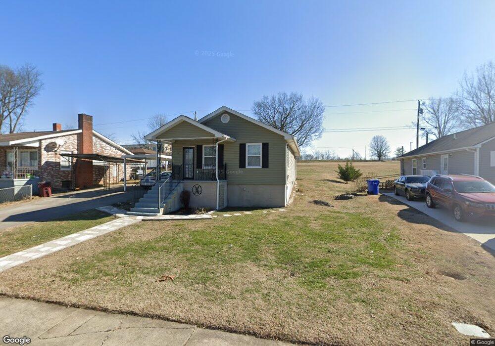
This home is located at 218 E Edison St, Alcoa, TN 37701 and is currently estimated at $226,926, approximately $273 per square foot. 218 E Edison St is a home located in Blount County with nearby schools including Alcoa Elementary School, Alcoa Middle School, and Alcoa High School.
Ownership History
Date
Name
Owned For
Owner Type
Purchase Details
Closed on
Mar 20, 2018
Sold by
Oliver Janet
Bought by
Mostella Jameelah
Current Estimated Value
Purchase Details
Closed on
Jan 29, 2018
Sold by
Oliver Janet
Bought by
Blount Co Habitat For Humanity
Purchase Details
Closed on
Feb 23, 2017
Sold by
Janet Oliver and Jackson Jocelyn
Bought by
Oliver Janet
Purchase Details
Closed on
May 25, 1960
Bought by
Minor George and Eunice Scott
Create a Home Valuation Report for This Property
The Home Valuation Report is an in-depth analysis detailing your home's value as well as a comparison with similar homes in the area
Home Values in the Area
Average Home Value in this Area
Purchase History
| Date | Buyer | Sale Price | Title Company |
|---|---|---|---|
| Mostella Jameelah | $117,000 | -- | |
| Blount Co Habitat For Humanity | $7,000 | -- | |
| Oliver Janet | -- | -- | |
| Oliver Janet | -- | -- | |
| Minor George | -- | -- |
Source: Public Records
Tax History
| Year | Tax Paid | Tax Assessment Tax Assessment Total Assessment is a certain percentage of the fair market value that is determined by local assessors to be the total taxable value of land and additions on the property. | Land | Improvement |
|---|---|---|---|---|
| 2025 | -- | $46,850 | $7,500 | $39,350 |
| 2024 | -- | $46,850 | $7,500 | $39,350 |
| 2023 | $1,537 | $46,850 | $7,500 | $39,350 |
| 2022 | $1,092 | $23,050 | $4,750 | $18,300 |
| 2021 | $977 | $23,050 | $4,750 | $18,300 |
| 2020 | $977 | $23,050 | $4,750 | $18,300 |
| 2019 | $977 | $23,050 | $4,750 | $18,300 |
| 2018 | $815 | $18,400 | $2,250 | $16,150 |
| 2017 | $100 | $2,250 | $2,250 | $0 |
| 2016 | $493 | $11,125 | $2,250 | $8,875 |
| 2015 | $457 | $11,125 | $2,250 | $8,875 |
| 2014 | $455 | $11,125 | $2,250 | $8,875 |
| 2013 | $455 | $11,050 | $0 | $0 |
Source: Public Records
Map
Nearby Homes
- 254 W Newcomen St
- 1538 Tsuga Dr
- 646 Kirkwell Dr
- 1321 Nobel St Unit E
- 0 N Wright Rd
- 1240 N Wright Rd
- 1413 Perkins St
- 1362 Dalton St
- 1631 Springbrook Rd
- 922 Poplar St
- 1450 Dalton St
- 1826 Peppertree Dr
- 869 Cedar St
- 1418 Mountain Quail Cir
- 966 Poplar St
- 614 Wright Rd
- 602 Mcginley St
- 1330 Mountain Quail Cir
- 971 Maple St
- 104 Roosevelt St
- 212 E Edison St
- 222 E Edison St
- 206 E Edison St
- 230 E Edison St
- 227 E Howe St
- 217 E Edison St
- 221 E Edison St
- 211 E Edison St
- 182 E Edison St
- 236 E Edison St
- 191 E Howe St
- 227 E Edison St
- 205 E Edison St
- 235 E Howe St
- 233 E Edison St
- 176 E Edison St
- 242 E Edison St
- 181 E Edison St
- 239 E Howe St
- 237 E Edison St
Your Personal Tour Guide
Ask me questions while you tour the home.