G
Seller's Agent in 2020
Gerrett Conover
Landvest MV


Estimated Value: $5,738,000
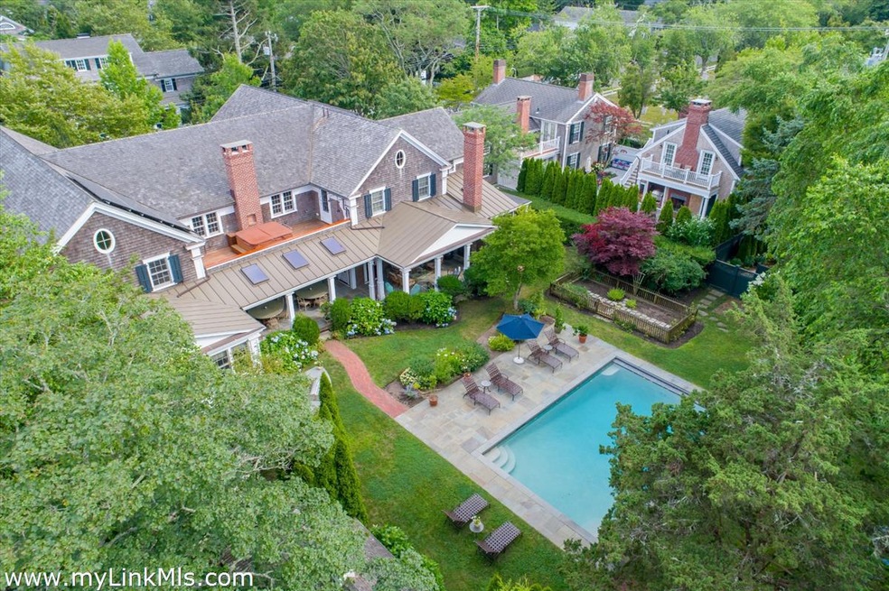
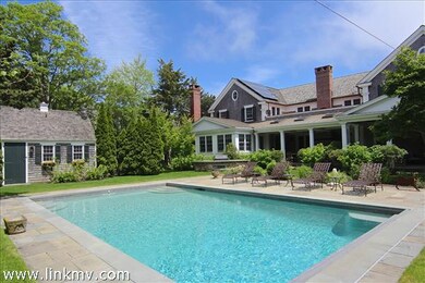
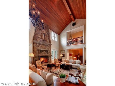
Custom built by and for high end Island builder so endless details abound! The house measures over 9,000 square feet with 5 ample bedrooms, 6 full baths and 3 powder rooms. It is wide open with rambling qualities to accommodate generational family gatherings. Easy going and aristocratic simultaneously blending old with new using sustainable materials including 200 year old flooring and beams. Perfect for summer entertaining with large covered porch complete with dining for 12, 2 fireplaces and wonderful living area overlooking the pool, yard and gardens. Every amenity possible including steam shower, sauna, 2 outside showers, hot tub, gym, theater, game room, mahogany inside/outside bar, office and breathtaking Lew French living room fireplace set in an inverted hull mahogany ceiling with 3 balconies overlooking this Great Room. Absolutely spectacular and a must see!
Last Agent to Sell the Property
Gerrett Conover
Landvest MV Listed on: 06/10/2020
Last Buyer's Agent
Gerrett Conover
Landvest MV Listed on: 06/10/2020
| Date | Buyer | Sale Price | Title Company |
|---|---|---|---|
| 22 Ppws Llc | $9,450,000 | None Available | |
| Margaret H White 2003 Ret | -- | None Available | |
| Goldberg-Dreesman Barbara | -- | -- | |
| White Margaret H | $470,000 | -- |
| Date | Status | Borrower | Loan Amount |
|---|---|---|---|
| Previous Owner | White Margaret H | $200,000 | |
| Previous Owner | White Margaret H | $500,000 |
| Date | Event | Price | List to Sale | Price per Sq Ft |
|---|---|---|---|---|
| 06/10/2020 06/10/20 | Sold | $9,450,000 | -- | $845 / Sq Ft |
| Year | Tax Paid | Tax Assessment Tax Assessment Total Assessment is a certain percentage of the fair market value that is determined by local assessors to be the total taxable value of land and additions on the property. | Land | Improvement |
|---|---|---|---|---|
| 2025 | $27,150 | $10,245,100 | $1,179,800 | $9,065,300 |
| 2024 | $24,057 | $9,434,300 | $1,179,800 | $8,254,500 |
| 2023 | $23,846 | $9,462,600 | $1,138,200 | $8,324,400 |
| 2022 | $22,697 | $7,490,800 | $1,123,600 | $6,367,200 |
| 2021 | $26,863 | $8,189,800 | $1,127,600 | $7,062,200 |
| 2020 | $27,436 | $8,189,800 | $1,127,600 | $7,062,200 |
| 2019 | $31,181 | $8,057,100 | $994,900 | $7,062,200 |
| 2018 | $23,570 | $7,020,500 | $977,400 | $6,043,100 |
| 2017 | $22,427 | $6,317,500 | $808,000 | $5,509,500 |
| 2016 | $20,561 | $5,679,800 | $808,000 | $4,871,800 |
| 2015 | $19,570 | $5,639,800 | $768,000 | $4,871,800 |
G
Seller's Agent in 2020
Gerrett Conover
Landvest MV
Source: LINK (Vineyard)
MLS Number: 36766
APN: EDGA-000020C-000182-000001