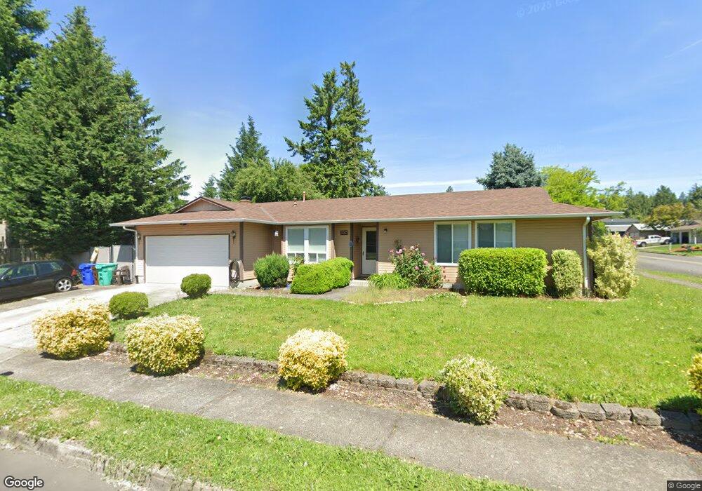
2203 SW 4th St Gresham, OR 97080
Hollybrook NeighborhoodEstimated Value: $390,000 - $458,000
3
Beds
2
Baths
1,325
Sq Ft
$321/Sq Ft
Est. Value
About This Home
This home is located at 2203 SW 4th St, Gresham, OR 97080 and is currently estimated at $425,708, approximately $321 per square foot. 2203 SW 4th St is a home located in Multnomah County with nearby schools including Hollydale Elementary School, Clear Creek Middle School, and Gresham High School.
Ownership History
Date
Name
Owned For
Owner Type
Purchase Details
Closed on
Mar 17, 2025
Sold by
Schackart Mark Alan
Bought by
Schackant Rebecca Lou
Current Estimated Value
Purchase Details
Closed on
Mar 23, 2006
Sold by
Schooley John
Bought by
Schackart Mark A and Schackart Rebecca L
Home Financials for this Owner
Home Financials are based on the most recent Mortgage that was taken out on this home.
Original Mortgage
$166,950
Interest Rate
6.25%
Mortgage Type
Fannie Mae Freddie Mac
Create a Home Valuation Report for This Property
The Home Valuation Report is an in-depth analysis detailing your home's value as well as a comparison with similar homes in the area
Home Values in the Area
Average Home Value in this Area
Purchase History
| Date | Buyer | Sale Price | Title Company |
|---|---|---|---|
| Schackant Rebecca Lou | -- | None Listed On Document | |
| Schackart Mark A | $208,700 | Fidelity Natl Title Co Of Or |
Source: Public Records
Mortgage History
| Date | Status | Borrower | Loan Amount |
|---|---|---|---|
| Previous Owner | Schackart Mark A | $166,950 |
Source: Public Records
Tax History
| Year | Tax Paid | Tax Assessment Tax Assessment Total Assessment is a certain percentage of the fair market value that is determined by local assessors to be the total taxable value of land and additions on the property. | Land | Improvement |
|---|---|---|---|---|
| 2025 | $4,661 | $229,060 | -- | -- |
| 2024 | $4,462 | $222,390 | -- | -- |
| 2023 | $4,462 | $215,920 | -- | -- |
| 2022 | $3,952 | $209,640 | $0 | $0 |
| 2021 | $3,852 | $203,540 | $0 | $0 |
| 2020 | $3,625 | $197,620 | $0 | $0 |
| 2019 | $3,530 | $191,870 | $0 | $0 |
| 2018 | $3,366 | $186,290 | $0 | $0 |
| 2017 | $3,229 | $180,870 | $0 | $0 |
| 2016 | $2,847 | $175,610 | $0 | $0 |
| 2015 | $2,786 | $170,500 | $0 | $0 |
| 2014 | $2,718 | $165,540 | $0 | $0 |
Source: Public Records
Map
Nearby Homes
- 44 SW Birdsdale Dr
- 21 NW Mawrcrest Ave
- 63 NW Mawrcrest Ave
- 85 NW Mawrcrest Ave
- 181 NW Mawrcrest Ave
- 185 NW Mawrcrest Ave
- 230 NW Mawrcrest Ave
- 236 NW Mawrcrest Ave
- 256 NW Mawrcrest Ave
- 296 NW Mawrcrest Ave
- 284 NW Mawrcrest Ave
- 2543 NW 2nd Terrace
- 2590 NW 2nd Terrace
- 2095 NW 3rd St
- 1960 SW 13th Ct
- 1175 SW Chastain Dr
- 163 SW Sandlewood Loop
- 159 SW Florence Ave Unit 64
- 159 SW Florence Ave
- 1113 W Powell Blvd
- 321 SW Birdsdale Dr
- 338 SW Lillyben Ave
- 2202 SW 4th St
- 318 SW Lillyben Ave
- 313 SW Birdsdale Dr
- 338 SW Birdsdale Dr
- 322 SW Birdsdale Dr
- 2212 SW 4th St
- 402 SW Birdsdale Dr
- 302 SW Lillyben Ave
- 318 SW Birdsdale Dr
- 417 SW Birdsdale Dr
- 301 SW Birdsdale Dr
- 2222 SW 4th St
- 412 SW Birdsdale Dr
- 298 SW Lillyben Ave
- 2231 SW 4th St
- 325 SW Wonderview Dr
- 400 SW Lillyben Ave
- 337 SW Wonderview Dr
Your Personal Tour Guide
Ask me questions while you tour the home.