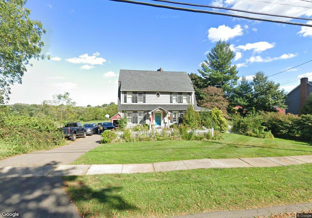
222 Griswold Rd Wethersfield, CT 06109
Estimated Value: $514,000 - $638,000
4
Beds
3
Baths
2,304
Sq Ft
$241/Sq Ft
Est. Value
About This Home
This home is located at 222 Griswold Rd, Wethersfield, CT 06109 and is currently estimated at $555,973, approximately $241 per square foot. 222 Griswold Rd is a home located in Hartford County with nearby schools including Highcrest School, Woodcrest Elementary School, and Silas Deane Middle School.
Ownership History
Date
Name
Owned For
Owner Type
Purchase Details
Closed on
Jul 3, 2013
Sold by
Warriner Richard S
Bought by
Murray Brian M and Murray Patricia S
Current Estimated Value
Home Financials for this Owner
Home Financials are based on the most recent Mortgage that was taken out on this home.
Original Mortgage
$275,000
Outstanding Balance
$197,147
Interest Rate
3.59%
Estimated Equity
$358,826
Purchase Details
Closed on
Mar 15, 2011
Sold by
Warriner Lynn Marie
Bought by
Warriner Richard S
Home Financials for this Owner
Home Financials are based on the most recent Mortgage that was taken out on this home.
Original Mortgage
$225,000
Interest Rate
4.83%
Create a Home Valuation Report for This Property
The Home Valuation Report is an in-depth analysis detailing your home's value as well as a comparison with similar homes in the area
Home Values in the Area
Average Home Value in this Area
Purchase History
| Date | Buyer | Sale Price | Title Company |
|---|---|---|---|
| Murray Brian M | $350,000 | -- | |
| Warriner Richard S | -- | -- |
Source: Public Records
Mortgage History
| Date | Status | Borrower | Loan Amount |
|---|---|---|---|
| Open | Warriner Richard S | $275,000 | |
| Previous Owner | Warriner Richard S | $225,000 | |
| Previous Owner | Warriner Richard S | $50,000 | |
| Previous Owner | Warriner Richard S | $139,000 |
Source: Public Records
Tax History Compared to Growth
Tax History
| Year | Tax Paid | Tax Assessment Tax Assessment Total Assessment is a certain percentage of the fair market value that is determined by local assessors to be the total taxable value of land and additions on the property. | Land | Improvement |
|---|---|---|---|---|
| 2025 | $12,695 | $307,970 | $96,610 | $211,360 |
| 2024 | $9,030 | $208,940 | $69,300 | $139,640 |
| 2023 | $8,730 | $208,940 | $69,300 | $139,640 |
| 2022 | $8,583 | $208,940 | $69,300 | $139,640 |
| 2021 | $8,498 | $208,940 | $69,300 | $139,640 |
| 2020 | $8,502 | $208,940 | $69,300 | $139,640 |
| 2019 | $8,512 | $208,940 | $69,300 | $139,640 |
| 2018 | $8,221 | $201,600 | $65,800 | $135,800 |
| 2017 | $8,018 | $201,600 | $65,800 | $135,800 |
| 2016 | $7,770 | $201,600 | $65,800 | $135,800 |
| 2015 | $7,699 | $201,600 | $65,800 | $135,800 |
| 2014 | $7,407 | $201,600 | $65,800 | $135,800 |
Source: Public Records
Map
Nearby Homes
- 217 Griswold Rd
- 227 Griswold Rd
- 207 Griswold Rd
- 239 Griswold Rd
- 199 Griswold Rd
- 254 Griswold Rd
- 62 Old Mill Rd
- 68 Old Mill Rd
- 54 Old Mill Rd
- 247 Griswold Rd
- 72 Old Mill Rd
- 255 Griswold Rd
- 33 Dorlen Cir
- 27 Dorlen Cir
- 264 Griswold Rd
- 44 Old Mill Rd
- 187 Griswold Rd
- 37 Dorlen Cir
- 265 Griswold Rd
- 19 Dorlen Cir