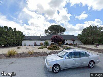
222 Saint Andrews Way Lompoc, CA 93436
Vandenberg Village NeighborhoodEstimated Value: $697,000 - $922,000
4
Beds
2
Baths
2,314
Sq Ft
$358/Sq Ft
Est. Value
About This Home
This home is located at 222 Saint Andrews Way, Lompoc, CA 93436 and is currently estimated at $828,845, approximately $358 per square foot. 222 Saint Andrews Way is a home located in Santa Barbara County with nearby schools including Buena Vista Elementary School, Cabrillo High School, and Olive Grove Charter - Lompoc.
Ownership History
Date
Name
Owned For
Owner Type
Purchase Details
Closed on
Mar 6, 2020
Sold by
Melone Jacqueline C
Bought by
Melone Jacqueline C and Jacqueline C Melone Trust
Current Estimated Value
Purchase Details
Closed on
Nov 24, 1997
Sold by
Melone Sabato J and Melone Jacqueline C
Bought by
Melone Sabato J and Melone Jacqueline C
Create a Home Valuation Report for This Property
The Home Valuation Report is an in-depth analysis detailing your home's value as well as a comparison with similar homes in the area
Home Values in the Area
Average Home Value in this Area
Purchase History
| Date | Buyer | Sale Price | Title Company |
|---|---|---|---|
| Melone Jacqueline C | -- | None Available | |
| Melone Jacqueline C | -- | None Available | |
| Melone Sabato J | -- | -- |
Source: Public Records
Mortgage History
| Date | Status | Borrower | Loan Amount |
|---|---|---|---|
| Closed | Melone Sabato J | $35,000 | |
| Closed | Melone Sabato J | $46,500 | |
| Closed | Melone Sabato J | $53,000 |
Source: Public Records
Tax History Compared to Growth
Tax History
| Year | Tax Paid | Tax Assessment Tax Assessment Total Assessment is a certain percentage of the fair market value that is determined by local assessors to be the total taxable value of land and additions on the property. | Land | Improvement |
|---|---|---|---|---|
| 2023 | $2,409 | $188,663 | $37,726 | $150,937 |
| 2022 | $2,371 | $184,965 | $36,987 | $147,978 |
| 2021 | $2,393 | $181,339 | $36,262 | $145,077 |
| 2020 | $2,370 | $179,481 | $35,891 | $143,590 |
| 2019 | $2,336 | $175,963 | $35,188 | $140,775 |
| 2018 | $2,304 | $172,514 | $34,499 | $138,015 |
| 2017 | $2,177 | $169,132 | $33,823 | $135,309 |
| 2016 | $1,870 | $165,816 | $33,160 | $132,656 |
| 2014 | $1,828 | $160,128 | $32,023 | $128,105 |
Source: Public Records
Map
Nearby Homes
- 259 Saint Andrews Way
- 259 St Andrews Way
- 3925 Clubhouse Ct
- 144 Oakmont Ave
- 369 Falcon Crest Dr
- 649 Burning Tree Way
- 140 Aries Ave
- 0 Oak Hill Dr Unit 24-783
- 288 Altair Ave
- 445 Firestone Way
- 4209 Constellation Rd
- 3956 Mesa Circle Dr Unit A
- 3947 Mesa Circle Dr Unit 3
- 401 Mars Ave
- 4210 Sirius Ave
- 500 Sunbeam Rd
- 538 Milky Way Unit 2
- 3875 Cassini Cir Unit 1
- 3725 Jupiter Ave
- 654 Carina Dr
- 222 Saint Andrews Way
- 3989 Club House Rd
- 221 Saint Andrews Way
- 221 St Andrews Way
- 238 Saint Andrews Way
- 241 Saint Andrews Way
- 3917 Club House Ct
- 3917 Clubhouse Ct
- 3921 Club House Ct
- 3925 Club House Ct
- 3913 Club House Ct
- 250 Saint Andrews Way
- 195 Oakmont Ave
- 216 Saint Annes Place
- 4024 Club House Rd
- 4036 Clubhouse Rd
- 4036 Club House Rd
- 3902 Club House Ct