Estimated Value: $162,786 - $193,000
6
Beds
2
Baths
2,350
Sq Ft
$77/Sq Ft
Est. Value
About This Home
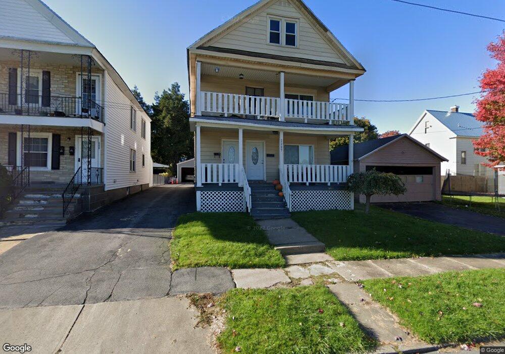
This home is located at 2227 Maynard Ave, Utica, NY 13502 and is currently estimated at $181,697, approximately $77 per square foot. 2227 Maynard Ave is a home located in Oneida County with nearby schools including Whitesboro High School and Tilton School.
Ownership History
Date
Name
Owned For
Owner Type
Purchase Details
Closed on
Oct 7, 2013
Sold by
Lashure Christopher
Bought by
Lashure Christopher
Current Estimated Value
Purchase Details
Closed on
May 16, 2007
Sold by
Rattray Allan D
Bought by
Lashure Christopher D
Home Financials for this Owner
Home Financials are based on the most recent Mortgage that was taken out on this home.
Original Mortgage
$84,829
Outstanding Balance
$34,760
Interest Rate
6.18%
Mortgage Type
Purchase Money Mortgage
Estimated Equity
$146,937
Purchase Details
Closed on
Apr 13, 2000
Sold by
Secretary Of Housing And Urban Development
Bought by
Rattray Allan D
Purchase Details
Closed on
Dec 30, 1999
Sold by
Sibley Mortgage Corp
Bought by
Secretary Of Hud
Purchase Details
Closed on
Jul 6, 1999
Purchase Details
Closed on
Mar 17, 1995
Create a Home Valuation Report for This Property
The Home Valuation Report is an in-depth analysis detailing your home's value as well as a comparison with similar homes in the area
Home Values in the Area
Average Home Value in this Area
Purchase History
| Date | Buyer | Sale Price | Title Company |
|---|---|---|---|
| Lashure Christopher | -- | -- | |
| Lashure Christopher D | $85,500 | -- | |
| Rattray Allan D | $24,000 | Bruce Daniels | |
| Secretary Of Hud | -- | -- | |
| -- | -- | -- | |
| -- | $69,216 | -- | |
| -- | -- | -- |
Source: Public Records
Mortgage History
| Date | Status | Borrower | Loan Amount |
|---|---|---|---|
| Open | Lashure Christopher D | $84,829 |
Source: Public Records
Tax History
| Year | Tax Paid | Tax Assessment Tax Assessment Total Assessment is a certain percentage of the fair market value that is determined by local assessors to be the total taxable value of land and additions on the property. | Land | Improvement |
|---|---|---|---|---|
| 2024 | $3,226 | $59,000 | $7,000 | $52,000 |
| 2023 | $3,779 | $59,000 | $7,000 | $52,000 |
| 2022 | $3,748 | $59,000 | $7,000 | $52,000 |
| 2021 | $3,711 | $59,000 | $7,000 | $52,000 |
| 2020 | $3,200 | $59,000 | $7,000 | $52,000 |
| 2019 | $2,657 | $59,000 | $7,000 | $52,000 |
| 2018 | $2,735 | $59,000 | $7,000 | $52,000 |
| 2017 | $2,657 | $59,000 | $7,000 | $52,000 |
| 2016 | $2,604 | $59,000 | $7,000 | $52,000 |
| 2015 | -- | $59,000 | $7,000 | $52,000 |
| 2014 | -- | $59,000 | $7,000 | $52,000 |
Source: Public Records
Map
Nearby Homes
- 2219 Highland Ave
- 1005 Ney Ave
- 1202 Kellogg Ave
- 16 1st St
- 1900 Caroline St
- 2216 Caroline St
- 1 Lamott Ave
- 1025 Churchill Ave
- 1208 Churchill Ave
- 54 Whitesboro St
- 930 Brayton Park Place
- 83 Campbell Ave
- 319 Winchester Dr
- 1230 Court St
- 1218 Court St
- 1422 Watkins Ave
- 1325 Ash St
- 1305 Oak St
- 140 Cross St
- 1213 Walnut St
- 2225 Maynard Ave
- 1017 Champlin Ave
- 1015 Champlin Ave
- 1023 Champlin Ave
- 2221 Maynard Ave
- 2216 Caroline St
- 2214 Caroline St
- 2219 Maynard Ave
- 2228 Maynard Ave
- 1025 Champlin Ave Unit 1
- 1025 Champlin Ave
- 2224 Maynard Ave
- 2212 Caroline St
- 1027 Champlin Ave
- 2226 Maynard Ave
- 2217 Maynard Ave
- 1005 Champlin Ave
- 2222 Maynard Ave
- 2215 Maynard Ave
Your Personal Tour Guide
Ask me questions while you tour the home.