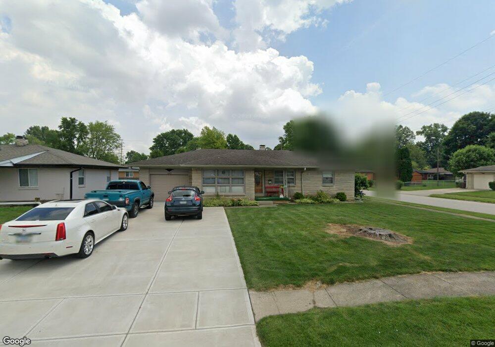
223 Brookside Ln Plainfield, IN 46168
Estimated Value: $228,000 - $280,000
3
Beds
2
Baths
1,316
Sq Ft
$186/Sq Ft
Est. Value
About This Home
This home is located at 223 Brookside Ln, Plainfield, IN 46168 and is currently estimated at $244,823, approximately $186 per square foot. 223 Brookside Ln is a home located in Hendricks County with nearby schools including Brentwood Elementary School, Plainfield Community Middle School, and Plainfield High School.
Ownership History
Date
Name
Owned For
Owner Type
Purchase Details
Closed on
Oct 18, 2007
Sold by
Helphinstine Larry E
Bought by
Martin Robert T and Martin Deborah J
Current Estimated Value
Home Financials for this Owner
Home Financials are based on the most recent Mortgage that was taken out on this home.
Original Mortgage
$85,000
Outstanding Balance
$52,153
Interest Rate
6.33%
Mortgage Type
New Conventional
Estimated Equity
$192,670
Create a Home Valuation Report for This Property
The Home Valuation Report is an in-depth analysis detailing your home's value as well as a comparison with similar homes in the area
Home Values in the Area
Average Home Value in this Area
Purchase History
| Date | Buyer | Sale Price | Title Company |
|---|---|---|---|
| Martin Robert T | -- | None Available |
Source: Public Records
Mortgage History
| Date | Status | Borrower | Loan Amount |
|---|---|---|---|
| Open | Martin Robert T | $85,000 |
Source: Public Records
Tax History
| Year | Tax Paid | Tax Assessment Tax Assessment Total Assessment is a certain percentage of the fair market value that is determined by local assessors to be the total taxable value of land and additions on the property. | Land | Improvement |
|---|---|---|---|---|
| 2024 | $1,222 | $178,500 | $27,000 | $151,500 |
| 2023 | $1,364 | $170,000 | $25,700 | $144,300 |
| 2022 | $1,386 | $161,800 | $24,400 | $137,400 |
| 2021 | $1,155 | $141,000 | $22,800 | $118,200 |
| 2020 | $1,164 | $141,400 | $22,800 | $118,600 |
| 2019 | $1,071 | $135,200 | $21,400 | $113,800 |
| 2018 | $1,224 | $144,500 | $21,400 | $123,100 |
| 2017 | $1,227 | $140,400 | $22,100 | $118,300 |
| 2016 | $1,151 | $134,900 | $22,100 | $112,800 |
| 2014 | $1,146 | $132,000 | $21,400 | $110,600 |
Source: Public Records
Map
Nearby Homes
- 324 Lawndale Dr
- 407 Dunn St
- 1710 Beechwood Dr
- 1713 Sycamore Dr
- 408 Linden Ln
- 504 Magnolia Dr
- 2668 Marjorie Ln
- 1429 Blackthorne Trail N
- 800 Walton Dr
- 2644 Prism Way
- 2654 Prism Way
- 2674 Prism Way
- 2686 Prism Way
- 9086 Anthem Ave
- 980 Andico Rd
- 228 Shaw St
- 446 Breakwater Dr
- 522 Breakwater Dr
- 911 Gary Dr
- 303 Green St
- 219 Brookside Ln
- 1527 Aubert St
- 1536 Aubert St
- 215 Brookside Ln
- 222 Wayside Dr
- 1539 Aubert St
- 1442 Aubert St
- 222 Brookside Ln
- 218 Wayside Dr Unit 220
- 211 Brookside Ln
- 308 Brookside Ln
- 218 Brookside Ln
- 312 Wayside Dr
- 214 Wayside Dr
- 317 Brookside Ln
- 312 Brookside Ln
- 207 Brookside Ln
- 214 Brookside Ln
- 316 Wayside Dr
Your Personal Tour Guide
Ask me questions while you tour the home.