Estimated Value: $241,000 - $292,000
3
Beds
2
Baths
1,746
Sq Ft
$151/Sq Ft
Est. Value
About This Home
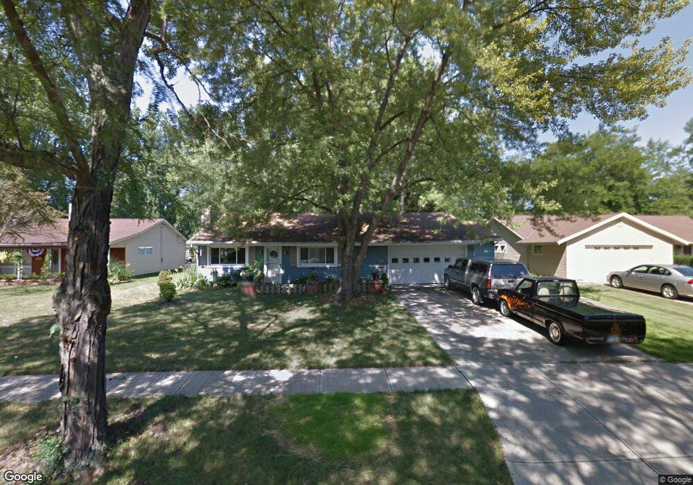
This home is located at 226 Sunset Dr, Berea, OH 44017 and is currently estimated at $264,067, approximately $151 per square foot. 226 Sunset Dr is a home located in Cuyahoga County with nearby schools including Grindstone Elementary School, Berea-Midpark Middle School, and Berea-Midpark High School.
Ownership History
Date
Name
Owned For
Owner Type
Purchase Details
Closed on
Mar 11, 2009
Sold by
Poore Michelle L and Wallingford Michelle L
Bought by
Benson Bonnie E
Current Estimated Value
Home Financials for this Owner
Home Financials are based on the most recent Mortgage that was taken out on this home.
Original Mortgage
$67,600
Interest Rate
5.09%
Mortgage Type
Purchase Money Mortgage
Purchase Details
Closed on
May 27, 2004
Sold by
Poore Kevin W and Poore Michelle L
Bought by
Poore Michelle L
Home Financials for this Owner
Home Financials are based on the most recent Mortgage that was taken out on this home.
Original Mortgage
$130,000
Interest Rate
6.06%
Mortgage Type
New Conventional
Purchase Details
Closed on
Oct 22, 1997
Sold by
Est Neil W Wesley
Bought by
Trustee Lawrence A Dusek Trustee & Ruth A D
Purchase Details
Closed on
Jan 1, 1975
Bought by
Wesley Neil W and Wesley S
Create a Home Valuation Report for This Property
The Home Valuation Report is an in-depth analysis detailing your home's value as well as a comparison with similar homes in the area
Home Values in the Area
Average Home Value in this Area
Purchase History
| Date | Buyer | Sale Price | Title Company |
|---|---|---|---|
| Benson Bonnie E | $137,600 | Chicago Title Insurance Co | |
| Poore Michelle L | -- | -- | |
| Trustee Lawrence A Dusek Trustee & Ruth A D | $59,000 | -- | |
| Wesley Neil W | -- | -- |
Source: Public Records
Mortgage History
| Date | Status | Borrower | Loan Amount |
|---|---|---|---|
| Previous Owner | Benson Bonnie E | $67,600 | |
| Previous Owner | Poore Michelle L | $130,000 |
Source: Public Records
Tax History
| Year | Tax Paid | Tax Assessment Tax Assessment Total Assessment is a certain percentage of the fair market value that is determined by local assessors to be the total taxable value of land and additions on the property. | Land | Improvement |
|---|---|---|---|---|
| 2025 | $4,377 | $75,565 | $13,755 | $61,810 |
| 2024 | $4,376 | $75,565 | $13,755 | $61,810 |
| 2023 | $4,146 | $60,030 | $12,460 | $47,570 |
| 2022 | $4,120 | $60,030 | $12,460 | $47,570 |
| 2021 | $4,085 | $60,030 | $12,460 | $47,570 |
| 2020 | $3,903 | $50,890 | $10,570 | $40,320 |
| 2019 | $3,799 | $145,400 | $30,200 | $115,200 |
| 2018 | $3,640 | $50,890 | $10,570 | $40,320 |
| 2017 | $3,759 | $46,980 | $9,350 | $37,630 |
| 2016 | $3,731 | $46,980 | $9,350 | $37,630 |
| 2015 | $3,526 | $46,980 | $9,350 | $37,630 |
| 2014 | $3,526 | $46,980 | $9,350 | $37,630 |
Source: Public Records
Map
Nearby Homes
- 160 Marian Ln Unit 6A
- 146 Marian Ln
- 169 Kempton Dr
- 380 Adrian Dr
- 143 Baker St
- 347 Beeler Dr
- 211 W Bridge St
- 333 Parkway Dr
- 516 Fair St
- 132 Stonefield Dr
- 57 Riverside Dr
- 147 Stone Ridge Way
- 487 Karen Dr
- 8783 Roberts Ct Unit 22A
- 23002 Chandlers Ln
- 23002 Chandlers Ln Unit 221
- 487 Bridle Ln
- 23003 Chandlers Ln Unit 224
- 23155 Wainwright Terrace
- 49 Monroe St
Your Personal Tour Guide
Ask me questions while you tour the home.