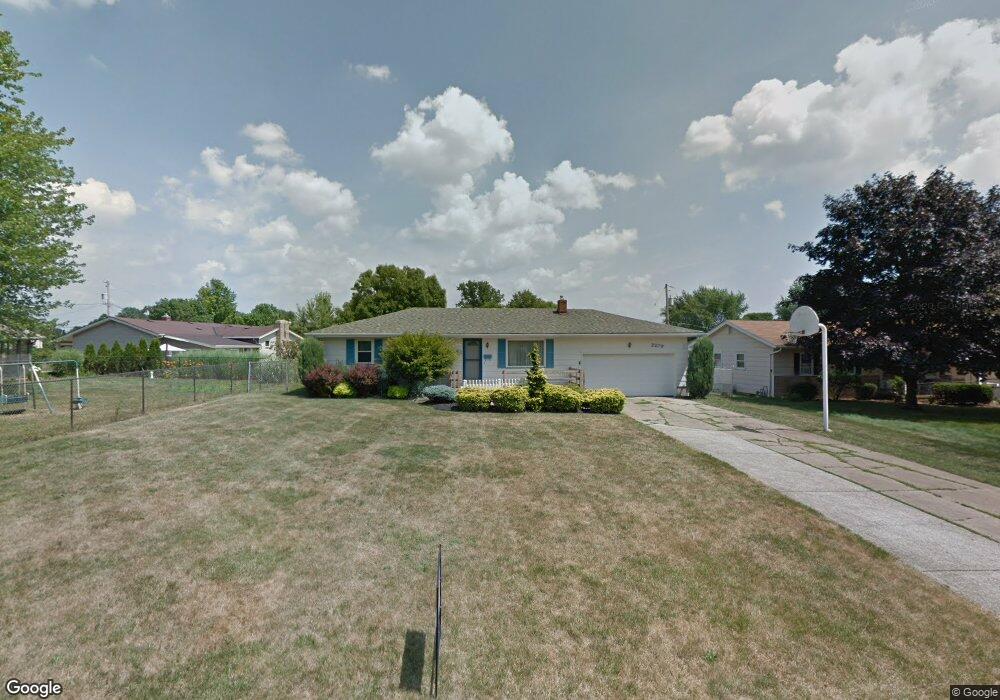
2279 Breezewood Dr Youngstown, OH 44515
Austintown NeighborhoodEstimated Value: $164,736 - $189,000
3
Beds
1
Bath
1,040
Sq Ft
$172/Sq Ft
Est. Value
About This Home
This home is located at 2279 Breezewood Dr, Youngstown, OH 44515 and is currently estimated at $178,434, approximately $171 per square foot. 2279 Breezewood Dr is a home located in Mahoning County with nearby schools including Austintown Elementary School, Austintown Intermediate School, and Austintown Middle School.
Ownership History
Date
Name
Owned For
Owner Type
Purchase Details
Closed on
Jan 29, 2020
Sold by
Dixon Clark Leroy and Dixon Nancy
Bought by
Dixon Clark Leroy and Dixon Nancy
Current Estimated Value
Purchase Details
Closed on
Aug 15, 2011
Sold by
Schumaker Judith H
Bought by
Dixon Clark Leroy and Dixon Nancy
Home Financials for this Owner
Home Financials are based on the most recent Mortgage that was taken out on this home.
Original Mortgage
$56,000
Outstanding Balance
$38,810
Interest Rate
4.59%
Mortgage Type
New Conventional
Estimated Equity
$139,624
Purchase Details
Closed on
Jan 1, 1990
Bought by
Schumaker Duane E and J H
Create a Home Valuation Report for This Property
The Home Valuation Report is an in-depth analysis detailing your home's value as well as a comparison with similar homes in the area
Home Values in the Area
Average Home Value in this Area
Purchase History
| Date | Buyer | Sale Price | Title Company |
|---|---|---|---|
| Dixon Clark Leroy | -- | None Available | |
| Dixon Clark Leroy | $70,000 | Attorney | |
| Schumaker Duane E | -- | -- |
Source: Public Records
Mortgage History
| Date | Status | Borrower | Loan Amount |
|---|---|---|---|
| Open | Dixon Clark Leroy | $56,000 |
Source: Public Records
Tax History Compared to Growth
Tax History
| Year | Tax Paid | Tax Assessment Tax Assessment Total Assessment is a certain percentage of the fair market value that is determined by local assessors to be the total taxable value of land and additions on the property. | Land | Improvement |
|---|---|---|---|---|
| 2024 | $2,072 | $45,240 | $6,960 | $38,280 |
| 2023 | $2,039 | $45,240 | $6,960 | $38,280 |
| 2022 | $1,734 | $30,840 | $6,220 | $24,620 |
| 2021 | $1,735 | $30,840 | $6,220 | $24,620 |
| 2020 | $1,742 | $30,840 | $6,220 | $24,620 |
| 2019 | $1,679 | $27,060 | $5,460 | $21,600 |
| 2018 | $1,615 | $27,060 | $5,460 | $21,600 |
| 2017 | $1,577 | $27,060 | $5,460 | $21,600 |
| 2016 | $1,543 | $25,630 | $6,140 | $19,490 |
| 2015 | $1,496 | $25,630 | $6,140 | $19,490 |
| 2014 | $1,502 | $25,630 | $6,140 | $19,490 |
| 2013 | $1,486 | $25,630 | $6,140 | $19,490 |
Source: Public Records
Map
Nearby Homes
- 2493 Frostwood Dr
- 4674 Barrington Dr
- 2414 Ardenwood Place
- 4689 Crabwood Dr
- 2211 Penny Ln
- 4815 New Rd
- 40 Woodleigh Ct
- 4314 Kerrybrook Dr
- 4289 Wedgewood Dr
- 1707 Westhampton Dr
- 4241 Wedgewood Dr
- 4235 Patricia Ave
- 3695 High Meadow Dr
- 3475 42nd St
- 2699 Hamman Dr
- 3481 Forty Second St
- 1228 Cavalcade Dr
- 4651 Warwick Dr S
- 4643 Warwick Dr S
- 4262 Pembrook Rd
- 2287 Breezewood Dr
- 4675 Woodridge Dr
- 4667 Woodridge Dr
- 2295 Breezewood Dr
- 2442 Frostwood Dr
- 4683 Woodridge Dr
- 2432 Frostwood Dr
- 2452 Frostwood Dr
- 2303 Breezewood Dr
- 2278 Breezewood Dr
- 2286 Breezewood Dr
- 2294 Breezewood Dr
- 4699 Woodridge Dr
- 2492 Frostwood Dr
- 2302 Breezewood Dr
- 2319 Breezewood Dr
- 4668 Woodridge Dr
- 4676 Woodridge Dr
- 2274 Frostwood Dr
- 2310 Breezewood Dr