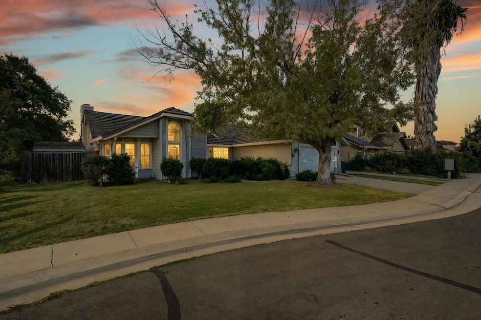
Welcome to 229 Sandpiper in beautiful Galt! This spacious single-story home offers 4 bedrooms, 2 full baths, and nearly 2,000 sq ft of comfortable living. The open-concept floor plan features a bright living room with vaulted ceilings, a cozy fireplace, and large windows that fill the space with natural light. The updated kitchen includes plenty of cabinet space, modern appliances, and a breakfast bar that opens to the family roomperfect for entertaining or relaxing. The primary suite boasts a walk-in closet, double sinks, and a soaking tub. Enjoy indoor laundry, a 2-car garage, and possible RV access for all your toys. The backyard is private and ready for your imaginationideal for gardening, gatherings, or summer barbecues. Located in a quiet, established neighborhood close to parks, schools, and shopping with easy freeway access. Pride of ownership shows throughoutthis is the one you've been waiting for!
Collateral Analytics
Collateral Analytics AVMs (Automated Valuation Model) employ a number of statistical approaches combined with neighborhood-specific comparable selection guarantees the most up-to-date and precise valuations.
Not Available
Collateral Analytics does not have data for the current month. Please view the chart for historical values.
ICE
ICE Mortgage Technology
ICE Mortgage Technology’s AVM (Automated Valuation Model) is a state-of-the-art online residential property valuation tool that provides a quick and accurate estimate of the value of almost any home in the U.S.
Not Available
ICE Mortgage Technology does not have data for the current month. Please view the chart for historical values.
First American
First American
First American Data & Analytics’ next-generation AVM combines unrivaled data assets with a blended ensemble of valuation models to produce highly accurate, reliable valuations you can trust.
Not Available
First American does not have data for the current month. Please view the chart for historical values.
Quantarium
Quantarium
Quantarium’s valuation service, repeatedly proven the industry’s most accurate and comprehensive, is supercharged with a self-learning and auto-tuning AI engine that continually becomes smarter and more accurate as it processes daily inputs from the industry’s leading RE data lake.
Not Available
Quantarium does not have data for the current month. Please view the chart for historical values.
Average Value
Not Available
List Price
Sold Price
Create a Home Valuation Report for This Property
The Home Valuation Report is an in-depth analysis detailing your home's value as well as a comparison with similar homes in the area
Home Values in the Area
Source: Public Records
Average Home Value in this Area
Source: Public Records
Tax History
We collect this data history from publicly available records. To have your information removed, we recommend requesting removal directly through your county’s website.
Year
Tax Paid
Tax AssessmentTax Assessment
Total Assessment is a certain percentage of the fair market value that is determined by local assessors to be the total taxable value of land and additions on the property.
Land
Improvement
2025
$4,066
$360,612
$72,401
$288,211
2024
$3,890
$353,542
$70,982
$282,560
2023
$3,823
$346,611
$69,591
$277,020
2022
$3,667
$339,816
$68,227
$271,589
2021
$3,670
$333,154
$66,890
$266,264
2020
$3,639
$329,739
$66,205
$263,534
2019
$3,547
$323,274
$64,907
$258,367
2018
$3,540
$316,936
$63,635
$253,301
2017
$3,400
$310,723
$62,388
$248,335
2016
$3,265
$304,631
$61,165
$243,466
2015
$3,152
$300,056
$60,247
$239,809
2014
$2,927
$274,484
$55,112
$219,372
Source: Public Records
Property History
We collect this data history from publicly available records. To have your information removed, we recommend requesting removal directly through your county’s website.
Date
Event
Price
List to Sale
Price per Sq Ft
03/02/202603/02/26
Price Changed
$583,000
-2.5%
$292 / Sq Ft
11/05/202511/05/25
For Sale
$598,000
--
$299 / Sq Ft
Source: MetroList
Purchase History
We collect this data history from publicly available records. To have your information removed, we recommend requesting removal directly through your county’s website.
Date
Type
Sale Price
Title Company
Grant Deed
$249,000
Old Republic Title Company
Source: Public Records
Mortgage History
We collect this data history from publicly available records. To have your information removed, we recommend requesting removal directly through your county’s website.
With over two decades of experience in the real estate industry, Neeta Petal is a dedicated REALTOR® at Vista Sotheby’s International Realty, specializing in residential properties throughout Amador County, Sacramento County , Calaveras County and surrounding areas. Known for her unwavering commitment to the "3 P’s"—Passion, Professionalism, and Personality—Neeta is a trusted partner to her clients, offering expert guidance and personalized service every step of the way. Her deep-rooted
Welcome to this charming and inviting home in the heart of Galt, the perfect opportunity for first time buyers, downsizer's, or anyone looking for comfort, space, and value all in one. This well maintained property offers 3 bedrooms, 2 bathrooms, and 1,178 sq ft of thoughtfully designed living space, creating a layout that feels both functional and welcoming. Built in 1982, the home has a
Tucked away at the end of a quiet cul-de-sac, this rare single-story 5 bedroom, 2 bath home offers the space, flexibility, and privacy today's buyers are searching for. Built in 2001 and situated on a generous 0.20 acre lot, this well-maintained home features approximately 1,414 square feet of comfortable living space designed to accommodate a variety of lifestyles. Step inside to discover fresh
Welcome to refined living in a gated Lodi community, tucked away on a quiet cul-de-sac. 2584 Lombardy Ct offers a balance of privacy, modern design, and low-maintenance lifestyle. Built in 2019, this well designed home offers approximately 2,072 sq ft with a flexible 2-3 bedroom layout and 2.5 baths. The floor plan reflects what today's buyers are looking for open, functional spaces with the
Welcome to 27 Omaha Court, a well located condo in the heart of Sacramento. This 3-bedroom, 1.5 bath residence offers 1,167 square feet of functional living space, ideal for first time buyers, investors, or those seeking a low maintenance lifestyle. The thoughtfully designed floor plan provides a comfortable balance of private and shared spaces, with generous room sizes and flexible living areas
First time on the market! Welcome to this beautifully remodeled home located just minutes from the charming and historic town of Sutter Creek. Offering the perfect balance of peaceful foothill living while still being close to town, this inviting property features 2 bedrooms, 2 bathrooms, a spacious 2-car garage, and an extra large lot that provides room to relax, garden, and enjoy the outdoors.
This updated 3-bedroom, 2-bathroom home features an owned solar system for lower utility bills and long-term savings. Located near the Amador County Fairgrounds, it sits on an oversized lot with plenty of space for gardening, a storage shed, fenced areas, and outdoor entertaining. Inside, enjoy fresh interior paint, updated flooring, and a large enclosed sunroom/covered porch offering flexible
Just shy of 60 acres with Sutter Creek flowing through itthis is your chance to own a stunning piece of Amador County history. Enjoy your morning coffee on the expansive wrap-around deck overlooking a majestic, tree-lined hillside. The spacious 3 bed, 2 bath manufactured home features vaulted ceilings, an oversized living room, dining area, and family roomeach with its own fireplace. This
Tucked away on 2.6 peaceful acres in the heart of Jackson, this beautifully maintained 3 bedroom, 3 bathroom property offers the perfect blend of privacy, comfort, and country charm. Located at 13730 June Way, this inviting home is ideal for those seeking space to breathe while still being conveniently close to town amenities, shopping, dining, and the beauty of Gold Country living. From the
Experience breathtaking, panoramic views from this one of a kind 11 acre mountain top retreat in Sutter Creek. Perched above the hills and trees, this two-story log cabin style home offers an indescribable sense of peace and elevationviews stretch in every direction. The 2 bedroom layout has space to easily convert into a 3 bedroom, making it ideal for full time living, a vacation getaway, or a
Disclaimer: Certain information contained herein is derived from information provided by parties other than Homes.com. All information provided is deemed reliable, but is not guaranteed to be accurate and should be independently verified.
IDX information is provided exclusively for personal, non-commercial use, and may not be used for any purpose other than to identify prospective properties consumers may be interested in purchasing. Information is deemed reliable but not guaranteed.