
Seller's Agent in 2025
Katherine Donahue
Sandpiper Realty Inc
(203) 988-1833
41 in this area
65 Total Sales
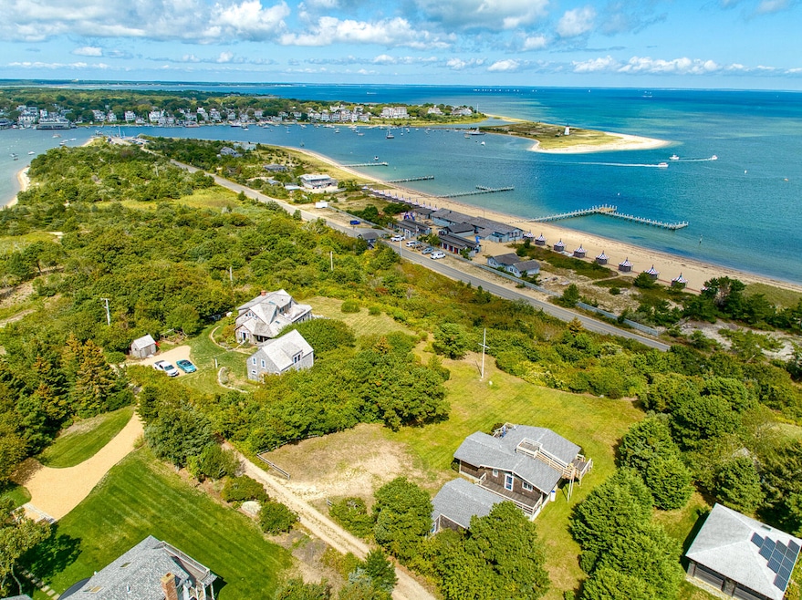
Enjoy dynamic, panoramic views from this charming and thoughtfully updated single-story Chappaquiddick cottage. Designed for effortless living, the home features an expansive deck overlooking the outer harbor and iconic lighthouse, perfect for entertaining or relaxation. A rooftop observation area provides additional seating and even more breathtaking vistas. Deeded beach access is conveniently located just across the way, offering a tranquil spot to enjoy the sandy shore and calm waters of the outer harbor. Ideally situated just off the Chappy Ferry, Manaca Hill offers the best of both worlds: easy access to the shops, dining, and vibrant charm of Downtown Edgartown, while embracing the laid-back, coastal lifestyle that makes Chappaquiddick so special.
Last Agent to Sell the Property
Sandpiper Realty Inc License #448010627 Listed on: 09/19/2025
Last Buyer's Agent
Buyer Unrepresented
mv.UnrepBuyer License #0
| Date | Type | Sale Price | Title Company |
|---|---|---|---|
| Quit Claim Deed | $3,200,000 | -- | |
| Deed | $1,995,000 | -- |
| Date | Status | Loan Amount | Loan Type |
|---|---|---|---|
| Previous Owner | $1,155,000 | Purchase Money Mortgage |
| Date | Event | Price | List to Sale | Price per Sq Ft |
|---|---|---|---|---|
| 11/18/2025 11/18/25 | Sold | $3,200,000 | 0.0% | $3,333 / Sq Ft |
| 10/29/2025 10/29/25 | Pending | -- | -- | -- |
| 09/19/2025 09/19/25 | For Sale | $3,200,000 | -- | $3,333 / Sq Ft |
| Year | Tax Paid | Tax Assessment Tax Assessment Total Assessment is a certain percentage of the fair market value that is determined by local assessors to be the total taxable value of land and additions on the property. | Land | Improvement |
|---|---|---|---|---|
| 2025 | $6,066 | $2,289,000 | $1,888,200 | $400,800 |
| 2024 | $5,666 | $2,222,000 | $1,842,100 | $379,900 |
| 2023 | $5,169 | $2,051,100 | $1,750,000 | $301,100 |
| 2022 | $5,333 | $1,760,102 | $1,565,802 | $194,300 |
| 2021 | $23,260 | $1,411,678 | $1,197,378 | $214,300 |
| 2020 | $5,146 | $1,535,990 | $1,381,590 | $154,400 |
| 2019 | $22,046 | $1,443,900 | $1,289,500 | $154,400 |
| 2018 | $5,626 | $1,453,800 | $1,335,500 | $118,300 |
| 2017 | $5,380 | $1,515,600 | $1,414,100 | $101,500 |
| 2016 | $5,450 | $1,505,400 | $1,414,100 | $91,300 |
| 2015 | $5,180 | $1,492,700 | $1,414,100 | $78,600 |
Seller's Agent in 2025
Katherine Donahue
Sandpiper Realty Inc
(203) 988-1833
41 in this area
65 Total Sales
B
Buyer's Agent in 2025
Buyer Unrepresented
mv.UnrepBuyer
Source: Martha's Vineyard MLS
MLS Number: 32500319
APN: EDGA-000030-000010
Disclaimer: Certain information contained herein is derived from information provided by parties other than Homes.com. All information provided is deemed reliable, but is not guaranteed to be accurate and should be independently verified.
![]() IDX information is provided exclusively for personal, non-commercial use, and may not be used for any purpose other than to identify prospective properties consumers may be interested in purchasing. Information is deemed reliable but not guaranteed.
IDX information is provided exclusively for personal, non-commercial use, and may not be used for any purpose other than to identify prospective properties consumers may be interested in purchasing. Information is deemed reliable but not guaranteed.
Ask me questions while you tour the home.