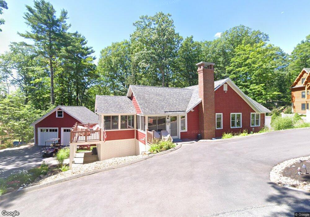
23 Wotanda Ln Meredith, NH 03253
Estimated Value: $892,000 - $1,557,000
3
Beds
2
Baths
1,305
Sq Ft
$870/Sq Ft
Est. Value
About This Home
This home is located at 23 Wotanda Ln, Meredith, NH 03253 and is currently estimated at $1,135,619, approximately $870 per square foot. 23 Wotanda Ln is a home located in Belknap County with nearby schools including Inter-Lakes Elementary School, Sandwich Central School, and Inter-Lakes Middle High School.
Ownership History
Date
Name
Owned For
Owner Type
Purchase Details
Closed on
Mar 9, 2021
Sold by
Whitehouse James R and Whitehouse Kim A
Bought by
Whitehouse Ft
Current Estimated Value
Purchase Details
Closed on
Oct 24, 2008
Sold by
Hopkins Kathryn D and Driscoll Joseph H
Bought by
Whitehouse James R and Whitehouse Kim A
Home Financials for this Owner
Home Financials are based on the most recent Mortgage that was taken out on this home.
Original Mortgage
$300,000
Interest Rate
5.94%
Mortgage Type
Purchase Money Mortgage
Create a Home Valuation Report for This Property
The Home Valuation Report is an in-depth analysis detailing your home's value as well as a comparison with similar homes in the area
Home Values in the Area
Average Home Value in this Area
Purchase History
| Date | Buyer | Sale Price | Title Company |
|---|---|---|---|
| Whitehouse Ft | -- | None Available | |
| Whitehouse James R | $375,000 | -- |
Source: Public Records
Mortgage History
| Date | Status | Borrower | Loan Amount |
|---|---|---|---|
| Previous Owner | Whitehouse James R | $282,000 | |
| Previous Owner | Whitehouse James R | $295,170 | |
| Previous Owner | Whitehouse James R | $300,000 |
Source: Public Records
Tax History
| Year | Tax Paid | Tax Assessment Tax Assessment Total Assessment is a certain percentage of the fair market value that is determined by local assessors to be the total taxable value of land and additions on the property. | Land | Improvement |
|---|---|---|---|---|
| 2024 | $9,160 | $892,800 | $574,200 | $318,600 |
| 2023 | $8,830 | $892,800 | $574,200 | $318,600 |
| 2022 | $6,796 | $486,500 | $270,400 | $216,100 |
| 2021 | $6,534 | $486,500 | $270,400 | $216,100 |
| 2020 | $5,961 | $425,200 | $270,400 | $154,800 |
| 2019 | $5,145 | $323,800 | $186,400 | $137,400 |
| 2018 | $5,058 | $323,800 | $186,400 | $137,400 |
| 2016 | $5,120 | $328,400 | $200,700 | $127,700 |
| 2015 | $4,992 | $328,400 | $200,700 | $127,700 |
| 2014 | $5,051 | $340,600 | $200,700 | $139,900 |
| 2013 | $4,908 | $340,600 | $200,700 | $139,900 |
Source: Public Records
Map
Nearby Homes
- Lot 21 Cummings Cove Rd
- Lot 22 Cummings Cove Rd
- 11 Quimby Rd
- 39 Lake Country Rd
- 43 Happy Homes Rd
- 75 Neal Shore Rd
- 45 Stern Castle Place Unit 32
- 37
- 38 Stern Castle Place Unit 30
- 9 Westbury Rd
- Lot 12-3 Needle Eye Rd
- Lot 12-5 Needle Eye Rd
- 598 Scenic Rd Unit 2
- 598 Scenic Rd Unit 1
- 97 Soleil Mountain Unit 82
- UNIT 41 Stonewall Corners Way Unit 41
- 6 Windjammer's Ridge
- 63 Commanders Helm
- 23 Deadreckoning Point
- 8 Deadreckoning Point
- 21 Wotanda Ln
- 27 Wotanda Ln
- 50 Old Barn Rd
- 26 Wotanda Ln
- 24 Wotanda Ln
- 54 Old Barn Rd
- 19 Wotanda Ln
- 28 Wotanda Ln
- 46 Old Barn Rd
- 51 Old Barn Rd
- 30 Wotanda Ln
- 41 Old Hubbard Rd
- 41 Old Hubbard Road and Boat Slip
- 22 Wotanda Ln
- 31 Wotanda Ln
- 20 Wotanda Ln
- 56 Old Barn Rd
- 47 Old Barn Rd
- 39 Old Hubbard Rd
- 55 Old Barn Rd