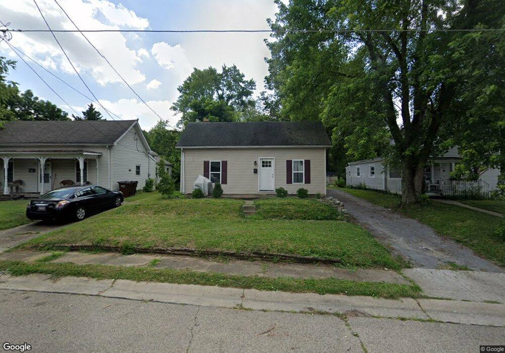
232 Allen St Franklin, OH 45005
Estimated Value: $84,000 - $209,000
3
Beds
1
Bath
1,782
Sq Ft
$91/Sq Ft
Est. Value
About This Home
This home is located at 232 Allen St, Franklin, OH 45005 and is currently estimated at $161,817, approximately $90 per square foot. 232 Allen St is a home located in Warren County with nearby schools including Franklin High School.
Ownership History
Date
Name
Owned For
Owner Type
Purchase Details
Closed on
May 18, 2022
Sold by
Sims Larry L
Bought by
Satterfield Roy
Current Estimated Value
Purchase Details
Closed on
Feb 27, 2008
Sold by
Deutsche Bank National Trust Co
Bought by
Mcintosh Donald W
Home Financials for this Owner
Home Financials are based on the most recent Mortgage that was taken out on this home.
Original Mortgage
$37,500
Interest Rate
5.75%
Mortgage Type
Purchase Money Mortgage
Purchase Details
Closed on
Nov 16, 2007
Sold by
Proffitt James and Case #Alias 06Cv67514
Bought by
Deutsche Bank National Trust Co
Purchase Details
Closed on
May 2, 1989
Sold by
Allen Allen and Allen Jeffrey D
Bought by
Proffit Proffit and Proffit James
Purchase Details
Closed on
Apr 27, 1983
Sold by
Her & Nay & True Yang
Bought by
Allen and Allen Jeffrey D
Purchase Details
Closed on
Nov 29, 1978
Sold by
Glossip Glossip and Glossip Tiff
Create a Home Valuation Report for This Property
The Home Valuation Report is an in-depth analysis detailing your home's value as well as a comparison with similar homes in the area
Home Values in the Area
Average Home Value in this Area
Purchase History
| Date | Buyer | Sale Price | Title Company |
|---|---|---|---|
| Satterfield Roy | $53,100 | Keith D Weiner & Associates | |
| Mcintosh Donald W | $37,600 | Sovereign Title Agency | |
| Deutsche Bank National Trust Co | $43,334 | None Available | |
| Proffit Proffit | $40,000 | -- | |
| Allen | $30,700 | -- | |
| -- | $24,000 | -- |
Source: Public Records
Mortgage History
| Date | Status | Borrower | Loan Amount |
|---|---|---|---|
| Previous Owner | Mcintosh Donald W | $37,500 |
Source: Public Records
Tax History
| Year | Tax Paid | Tax Assessment Tax Assessment Total Assessment is a certain percentage of the fair market value that is determined by local assessors to be the total taxable value of land and additions on the property. | Land | Improvement |
|---|---|---|---|---|
| 2025 | $1,602 | $33,300 | $8,130 | $25,170 |
| 2024 | $1,602 | $33,300 | $8,130 | $25,170 |
| 2023 | $1,364 | $25,431 | $4,613 | $20,818 |
| 2022 | $1,065 | $25,431 | $4,613 | $20,818 |
| 2021 | $2,576 | $25,431 | $4,613 | $20,818 |
| 2020 | $3,226 | $20,181 | $3,661 | $16,520 |
| 2019 | $1,939 | $20,181 | $3,661 | $16,520 |
| 2018 | $1,025 | $20,181 | $3,661 | $16,520 |
| 2017 | $1,075 | $19,079 | $3,514 | $15,565 |
| 2016 | $1,096 | $19,079 | $3,514 | $15,565 |
| 2015 | $1,096 | $19,079 | $3,514 | $15,565 |
| 2014 | $1,110 | $19,080 | $3,510 | $15,560 |
| 2013 | $957 | $22,070 | $4,070 | $18,000 |
Source: Public Records
Map
Nearby Homes
- 202 E 2nd St
- 45 W 3rd St
- 0 E 4th St
- 551 E 2nd St
- 11 Highridge Ct
- 5 S River St
- 21 Skokiaan Dr
- 388 Thomas Dr
- 527 S Main St
- 205 Oxford Rd
- 0 Victoria Dr Unit 942075
- 0 Victoria Dr Unit 1852824
- 309 Oxford Rd
- 1200 Riley Blvd
- 747 David Blvd
- 760 David Blvd
- 705 S Main St
- 627 S River St
- 409 Millard Dr
- 228 Bridge St
Your Personal Tour Guide
Ask me questions while you tour the home.