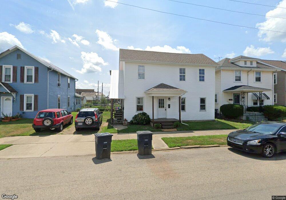
232 Union St Lancaster, OH 43130
Estimated Value: $221,000 - $259,000
3
Beds
3
Baths
3,114
Sq Ft
$79/Sq Ft
Est. Value
About This Home
This home is located at 232 Union St, Lancaster, OH 43130 and is currently estimated at $246,000, approximately $78 per square foot. 232 Union St is a home located in Fairfield County with nearby schools including Thomas Ewing Junior High School, Lancaster High School, and St Mary Elementary School.
Ownership History
Date
Name
Owned For
Owner Type
Purchase Details
Closed on
Mar 11, 2022
Sold by
Charles Griffith Philip
Bought by
Griffith Homestead Trust
Current Estimated Value
Purchase Details
Closed on
Oct 10, 2018
Sold by
Griffith Philip Charles and Griffith Mary Janet
Bought by
Griffith Philip C and Griffith Mary Janet
Purchase Details
Closed on
Oct 3, 2008
Sold by
Griffith Philip and Griffith Janet
Bought by
Griffith Philip Charles and Griffith Mary Janet
Create a Home Valuation Report for This Property
The Home Valuation Report is an in-depth analysis detailing your home's value as well as a comparison with similar homes in the area
Home Values in the Area
Average Home Value in this Area
Purchase History
| Date | Buyer | Sale Price | Title Company |
|---|---|---|---|
| Griffith Homestead Trust | -- | -- | |
| Griffith Philip C | -- | None Available | |
| Griffith Philip Charles | -- | Valmer Land Title Agency |
Source: Public Records
Tax History
| Year | Tax Paid | Tax Assessment Tax Assessment Total Assessment is a certain percentage of the fair market value that is determined by local assessors to be the total taxable value of land and additions on the property. | Land | Improvement |
|---|---|---|---|---|
| 2025 | $4,330 | $74,480 | $17,550 | $56,930 |
| 2024 | $4,330 | $48,160 | $9,170 | $38,990 |
| 2023 | $1,789 | $48,160 | $9,170 | $38,990 |
| 2022 | $2,048 | $48,160 | $9,170 | $38,990 |
| 2021 | $1,521 | $38,130 | $9,170 | $28,960 |
| 2020 | $1,459 | $38,130 | $9,170 | $28,960 |
| 2019 | $1,388 | $38,130 | $9,170 | $28,960 |
| 2018 | $1,575 | $34,690 | $9,170 | $25,520 |
| 2017 | $1,576 | $41,070 | $7,930 | $33,140 |
| 2016 | $1,536 | $41,070 | $7,930 | $33,140 |
| 2015 | $1,590 | $41,270 | $7,930 | $33,340 |
| 2014 | $1,517 | $41,270 | $7,930 | $33,340 |
| 2013 | $1,517 | $41,270 | $7,930 | $33,340 |
Source: Public Records
Map
Nearby Homes
- 233 Union St
- 0 Slocum Ave
- 515 N Columbus St
- 526 N Columbus St
- 0 N Columbus St
- 520 W Wheeling St
- 123 Arnold Ave
- 154 E Main St
- 600 N High St
- 820 N Broad St
- 249 N Pearl Ave
- 130 W Fair Ave
- 757 W Mulberry St
- 233 E 6th Ave
- 336 Reber Ave
- 165 Lake St
- 302 Washington Ave
- 157 Cedar Hill Rd
- 330 Park St
- 311 E Allen St
- 228 Union St
- 326 Forest Rose Ave
- 324 Forest Rose Ave
- 238 Union St
- 224 Union St
- 240 Union St
- 322 Forest Rose Ave
- 4193 Demorest Cove Ct
- 220 Union St
- 316 Forest Rose Ave
- 312 Forest Rose Ave
- 241 Union St
- 235 W Mulberry St
- 338 N Memorial Dr
- 231 Union St
- 229 Union St
- 219 Union St
- 315 N Columbus St
- 410 Forest Rose Ave
- 227 W Mulberry St
Your Personal Tour Guide
Ask me questions while you tour the home.