Estimated Value: $243,000 - $274,000
3
Beds
3
Baths
1,598
Sq Ft
$162/Sq Ft
Est. Value
About This Home
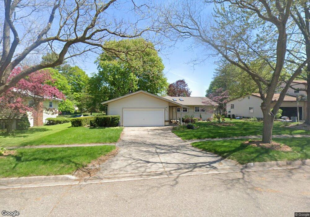
This home is located at 233 Mark St, Mason, MI 48854 and is currently estimated at $258,755, approximately $161 per square foot. 233 Mark St is a home located in Ingham County with nearby schools including Mason High School.
Ownership History
Date
Name
Owned For
Owner Type
Purchase Details
Closed on
Jun 12, 2013
Sold by
Box Gale L and Box Leona M
Bought by
Carr Cathy D
Current Estimated Value
Purchase Details
Closed on
Jan 17, 2013
Sold by
Carr William H
Bought by
Carr William H and Carr Cathy D
Purchase Details
Closed on
Jul 21, 2006
Sold by
Brower Ross G and Brower Julie W
Bought by
Carr William H
Home Financials for this Owner
Home Financials are based on the most recent Mortgage that was taken out on this home.
Original Mortgage
$87,000
Interest Rate
6.73%
Mortgage Type
Purchase Money Mortgage
Purchase Details
Closed on
May 26, 1989
Sold by
Julie Broweer
Create a Home Valuation Report for This Property
The Home Valuation Report is an in-depth analysis detailing your home's value as well as a comparison with similar homes in the area
Home Values in the Area
Average Home Value in this Area
Purchase History
| Date | Buyer | Sale Price | Title Company |
|---|---|---|---|
| Carr Cathy D | -- | None Available | |
| Carr William H | -- | None Available | |
| Carr William H | $187,500 | Trans | |
| -- | $77,900 | -- |
Source: Public Records
Mortgage History
| Date | Status | Borrower | Loan Amount |
|---|---|---|---|
| Previous Owner | Carr William H | $87,000 |
Source: Public Records
Tax History
| Year | Tax Paid | Tax Assessment Tax Assessment Total Assessment is a certain percentage of the fair market value that is determined by local assessors to be the total taxable value of land and additions on the property. | Land | Improvement |
|---|---|---|---|---|
| 2025 | $4,797 | $123,810 | $30,470 | $93,340 |
| 2024 | $4,504 | $115,440 | $30,470 | $84,970 |
| 2023 | $4,504 | $113,700 | $28,070 | $85,630 |
| 2022 | $4,295 | $101,570 | $28,520 | $73,050 |
| 2021 | $4,185 | $97,400 | $28,520 | $68,880 |
| 2020 | $4,052 | $87,230 | $28,520 | $58,710 |
| 2019 | $3,913 | $83,050 | $22,410 | $60,640 |
| 2018 | $3,843 | $85,540 | $20,370 | $65,170 |
| 2017 | $3,483 | $85,540 | $20,370 | $65,170 |
| 2016 | -- | $76,370 | $10,590 | $65,780 |
| 2015 | -- | $68,530 | $21,189 | $47,341 |
| 2014 | -- | $67,740 | $34,636 | $33,104 |
Source: Public Records
Map
Nearby Homes
- 202 Stratford Dr
- 703 E Columbia St
- 584 Vanderveen Dr
- 334 E Elm St
- 404 E Cherry St
- 537 Vanderveen Dr
- 0 Sanctuary
- 00 Sanctuary
- 32 Aviemore Dr Unit 32
- 833 S Barnes St
- 514 W Maple St
- 990 Windjammer Ct
- 318 Ives Rd
- 501 Middlebury Ln
- 307 Ives Rd
- 1470 N Cedar St
- 105 Carom Cir
- 902 Eagles Nest Ct
- 311 Carom Cir Unit 59
- 607 Carom Cir
Your Personal Tour Guide
Ask me questions while you tour the home.