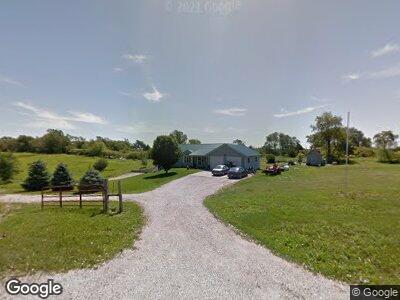
23859 Jasper Ln Underwood, IA 51576
Estimated Value: $312,000 - $441,000
2
Beds
3
Baths
1,474
Sq Ft
$267/Sq Ft
Est. Value
About This Home
This home is located at 23859 Jasper Ln, Underwood, IA 51576 and is currently estimated at $392,998, approximately $266 per square foot. 23859 Jasper Ln is a home located in Pottawattamie County with nearby schools including Underwood Elementary School, Underwood Middle School, and Underwood High School.
Ownership History
Date
Name
Owned For
Owner Type
Purchase Details
Closed on
Nov 25, 2024
Sold by
Darnold Jill L
Bought by
Darnold Randall J
Current Estimated Value
Purchase Details
Closed on
Dec 20, 2023
Sold by
Darnold Randall J and Darnold Jill L
Bought by
Darnold Randall J and Darnold Jill L
Purchase Details
Closed on
Mar 23, 2012
Sold by
Darnold Naomi May and Darnold Randail J
Bought by
Darnold Randall J and Darnold Jill L
Home Financials for this Owner
Home Financials are based on the most recent Mortgage that was taken out on this home.
Original Mortgage
$305,000
Interest Rate
3.9%
Mortgage Type
Commercial
Create a Home Valuation Report for This Property
The Home Valuation Report is an in-depth analysis detailing your home's value as well as a comparison with similar homes in the area
Home Values in the Area
Average Home Value in this Area
Purchase History
| Date | Buyer | Sale Price | Title Company |
|---|---|---|---|
| Darnold Randall J | -- | None Listed On Document | |
| Darnold Randall J | $300,000 | Dakota Title & Escrow Co |
Source: Public Records
Mortgage History
| Date | Status | Borrower | Loan Amount |
|---|---|---|---|
| Previous Owner | Darnold Randall J | $181,000 | |
| Previous Owner | Darnold Randall J | $305,000 | |
| Previous Owner | Darnold Randall J | $168,000 | |
| Previous Owner | Darnold Randall J | $62,000 |
Source: Public Records
Tax History Compared to Growth
Tax History
| Year | Tax Paid | Tax Assessment Tax Assessment Total Assessment is a certain percentage of the fair market value that is determined by local assessors to be the total taxable value of land and additions on the property. | Land | Improvement |
|---|---|---|---|---|
| 2024 | $3,094 | $244,200 | $4,400 | $239,800 |
| 2023 | $3,094 | $244,200 | $4,400 | $239,800 |
| 2022 | $2,854 | $199,600 | $3,200 | $196,400 |
| 2021 | $4,344 | $193,300 | $3,200 | $190,100 |
| 2020 | $2,944 | $193,300 | $3,200 | $190,100 |
| 2019 | $2,828 | $193,300 | $3,200 | $190,100 |
| 2018 | $2,786 | $183,900 | $5,000 | $178,900 |
| 2017 | $3,186 | $199,414 | $9,814 | $189,600 |
| 2015 | $2,838 | $180,914 | $9,814 | $171,100 |
| 2014 | $2,438 | $156,714 | $9,814 | $146,900 |
Source: Public Records
Map
Nearby Homes
- 10 4th Ave
- 507 Hope Ave
- 24011 Hunt Ave
- 18684 Taylor Ln
- 101 Mulberry Cir
- LOT 2 Stoneridge Ct
- LOT 1 Stoneridge Ct
- LOT 5 Stoneridge Ct
- 115 Mulberry Cir
- 18325 Jaylen Dr
- 413 5th St
- LOT 10 Stoneridge Ct
- LOT 9 Stoneridge Ct
- LOT 7 Stoneridge Ct
- 24310 Richfield Loop
- 99 Rosa Dr
- 1002 Hillside Dr
- 1004 Hillside Dr
- 1009 Hillside Dr
- 200 Laurie Cir
- 23859 Jasper Ln
- 23864 Jasper Ln
- 28194 Juniper Rd
- 27919 Juniper Rd
- 27677 Juniper Rd
- 28566 Juniper Rd
- 27555 Juniper Rd
- 23398 282nd St
- 27401 Juniper Rd
- 1 Juniper Rd
- 28758 Jackson Ave
- 23156 282nd St
- 23156 282nd St
- 23391 272nd St
- 28839 Jackson Ave
- 32.98 AC 272nd St
- 97.86 ACRE Jackson
- 23217 272nd St
- 272ND 272nd St
- 24329 272nd St