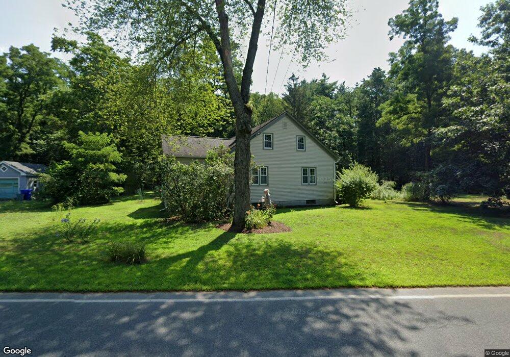
240 S Silver Ln Sunderland, MA 01375
Estimated Value: $398,000 - $474,000
3
Beds
2
Baths
1,608
Sq Ft
$271/Sq Ft
Est. Value
About This Home
This home is located at 240 S Silver Ln, Sunderland, MA 01375 and is currently estimated at $436,038, approximately $271 per square foot. 240 S Silver Ln is a home located in Franklin County with nearby schools including Sunderland Elementary School and Frontier Regional School.
Ownership History
Date
Name
Owned For
Owner Type
Purchase Details
Closed on
May 14, 2004
Sold by
Glenowicz Frank M
Bought by
Michaels Karen and Michaels Sala
Current Estimated Value
Home Financials for this Owner
Home Financials are based on the most recent Mortgage that was taken out on this home.
Original Mortgage
$196,000
Outstanding Balance
$90,317
Interest Rate
5.47%
Mortgage Type
Purchase Money Mortgage
Estimated Equity
$345,721
Purchase Details
Closed on
Apr 27, 2001
Sold by
Nuerminger Todd W and Nuerminger Robert L
Bought by
Glenowicz Frank M
Purchase Details
Closed on
Apr 30, 1996
Sold by
Norris Brian A and Rule-Norris Catherine
Bought by
Nuerminger Todd W and Nuerminger Roberta L
Purchase Details
Closed on
Dec 21, 1992
Sold by
Brennan Kevin P and Brennan Dwyer-Brennan K
Bought by
Noris Brian A and Noris Rule-Norris C
Purchase Details
Closed on
Jul 17, 1989
Sold by
Bowen Clifford V
Bought by
Brennan Kevin P
Purchase Details
Closed on
Dec 21, 1988
Sold by
Tenney Joseph W
Bought by
Frazier Michael
Create a Home Valuation Report for This Property
The Home Valuation Report is an in-depth analysis detailing your home's value as well as a comparison with similar homes in the area
Home Values in the Area
Average Home Value in this Area
Purchase History
| Date | Buyer | Sale Price | Title Company |
|---|---|---|---|
| Michaels Karen | $245,000 | -- | |
| Glenowicz Frank M | $169,900 | -- | |
| Nuerminger Todd W | $141,000 | -- | |
| Noris Brian A | $131,000 | -- | |
| Brennan Kevin P | $138,000 | -- | |
| Frazier Michael | $93,000 | -- |
Source: Public Records
Mortgage History
| Date | Status | Borrower | Loan Amount |
|---|---|---|---|
| Open | Frazier Michael | $196,000 | |
| Previous Owner | Frazier Michael | $172,000 |
Source: Public Records
Tax History Compared to Growth
Tax History
| Year | Tax Paid | Tax Assessment Tax Assessment Total Assessment is a certain percentage of the fair market value that is determined by local assessors to be the total taxable value of land and additions on the property. | Land | Improvement |
|---|---|---|---|---|
| 2025 | $38 | $295,000 | $124,800 | $170,200 |
| 2024 | $3,876 | $295,000 | $124,800 | $170,200 |
| 2023 | $3,521 | $275,100 | $113,400 | $161,700 |
| 2022 | $3,513 | $239,000 | $97,200 | $141,800 |
| 2021 | $3,295 | $212,700 | $90,100 | $122,600 |
| 2020 | $3,284 | $212,700 | $90,100 | $122,600 |
| 2019 | $3,169 | $206,700 | $87,500 | $119,200 |
| 2018 | $3,048 | $203,200 | $84,000 | $119,200 |
| 2017 | $2,898 | $202,100 | $84,000 | $118,100 |
| 2016 | $2,997 | $204,400 | $82,300 | $122,100 |
| 2015 | $2,925 | $204,400 | $82,300 | $122,100 |
| 2014 | $2,858 | $204,400 | $82,300 | $122,100 |
Source: Public Records
Map
Nearby Homes
- 15 S Plain Rd
- 146 Old Amherst Rd
- 110 Old Amherst Rd
- 3 Depot Rd
- 238 N Main St
- 73 Depot Rd
- 113 Juggler Meadow Rd
- Lot C Mountain Rd
- Lot A Mountain Rd
- Lot B Mountain Rd
- 259 Long Plain Rd
- Lot 3A-3 Leverett Rd
- 7 Roosevelt St
- 15 Crestview Dr
- 40 Eastern Ave
- 39 Valley Ln
- 958 E Pleasant St
- 0 Henry St
- 24 Graves St
- 134 Montague Rd