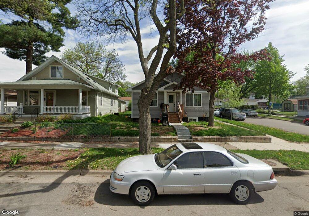
241 Robie St E Saint Paul, MN 55107
West Side NeighborhoodEstimated Value: $313,000 - $349,000
4
Beds
2
Baths
1,176
Sq Ft
$284/Sq Ft
Est. Value
About This Home
This home is located at 241 Robie St E, Saint Paul, MN 55107 and is currently estimated at $334,485, approximately $284 per square foot. 241 Robie St E is a home with nearby schools including Cherokee Heights Elementary School, Humboldt Secondary School, and Quantum STEAM Academy.
Ownership History
Date
Name
Owned For
Owner Type
Purchase Details
Closed on
Aug 11, 2016
Sold by
Peterson John John
Bought by
Daniel Daniel
Current Estimated Value
Home Financials for this Owner
Home Financials are based on the most recent Mortgage that was taken out on this home.
Original Mortgage
$204,232
Outstanding Balance
$162,953
Interest Rate
3.48%
Mortgage Type
FHA
Estimated Equity
$171,532
Purchase Details
Closed on
Sep 10, 2015
Sold by
Maryknoll Llc
Bought by
Peterson John
Purchase Details
Closed on
Oct 8, 2014
Sold by
Elizondo Shirley M
Bought by
Maryknoll Llc
Home Financials for this Owner
Home Financials are based on the most recent Mortgage that was taken out on this home.
Original Mortgage
$60,000
Interest Rate
4.19%
Create a Home Valuation Report for This Property
The Home Valuation Report is an in-depth analysis detailing your home's value as well as a comparison with similar homes in the area
Home Values in the Area
Average Home Value in this Area
Purchase History
| Date | Buyer | Sale Price | Title Company |
|---|---|---|---|
| Daniel Daniel | $208,000 | -- | |
| Kapp Serotoff Daniel | $214,303 | Executive Title | |
| Peterson John | $31,000 | Fsa Title Services Llc | |
| Maryknoll Llc | $61,818 | Fsa Title Services Llc | |
| -- | $60,000 | -- |
Source: Public Records
Mortgage History
| Date | Status | Borrower | Loan Amount |
|---|---|---|---|
| Open | Kapp Serotoff Daniel | $204,232 | |
| Closed | Daniel Daniel | $204,400 | |
| Previous Owner | -- | $60,000 | |
| Previous Owner | Maryknoll Llc | $94,000 |
Source: Public Records
Tax History
| Year | Tax Paid | Tax Assessment Tax Assessment Total Assessment is a certain percentage of the fair market value that is determined by local assessors to be the total taxable value of land and additions on the property. | Land | Improvement |
|---|---|---|---|---|
| 2025 | $4,718 | $326,200 | $23,200 | $303,000 |
| 2023 | $4,718 | $278,700 | $18,000 | $260,700 |
| 2022 | $4,828 | $272,700 | $18,000 | $254,700 |
| 2021 | $4,110 | $274,800 | $18,000 | $256,800 |
| 2020 | $3,962 | $225,800 | $18,000 | $207,800 |
| 2019 | $3,348 | $226,500 | $18,000 | $208,500 |
| 2018 | $3,154 | $202,400 | $18,000 | $184,400 |
| 2017 | $702 | $199,900 | $18,000 | $181,900 |
| 2016 | $346 | $0 | $0 | $0 |
| 2015 | $480 | $18,000 | $18,000 | $0 |
| 2014 | $496 | $0 | $0 | $0 |
Source: Public Records
Map
Nearby Homes
- 303 Cesar Chavez St
- 568 State St Unit C
- 277 Morton St E
- 344 Page St E
- 567 Livingston Ave
- 405 Robert St S
- 66 Stevens St E
- 246 Sidney St E
- 655 Robert St S
- 37 King St E
- 755 Robert St S
- 492 Curtice St E
- 274 Wyoming St E
- 188 Wyoming St E
- 71 Winifred St W
- 181 Annapolis St E
- 5 Belvidere St E
- 84 Isabel St W
- 40 Winona St E
- 2 Belvidere St E
- 235 Robie St E
- 245 Robie St E
- 233 Robie St E
- 249 Robie St E
- 240 Winifred St E
- 225 Robie St E
- 234 Winifred St E
- 246 Winifred St E
- 517 Anita St
- 255 Robie St W
- 255 Robie St E
- 232 Winifred St E
- 236 Robie St E
- 223 Robie St E
- 252 Winifred St E
- 252 252 Robie St E
- 522 Anita St
- 232 Winifred St E
- 234 Robie St E
- 226 Winifred St E
Your Personal Tour Guide
Ask me questions while you tour the home.