2414 River Rd Cincinnati, OH 45204
East Price Hill NeighborhoodEstimated payment $2,374/month
Highlights
- River View
- 1.07 Acre Lot
- No HOA
- Walnut Hills High School Rated A+
- Partially Wooded Lot
About This Lot
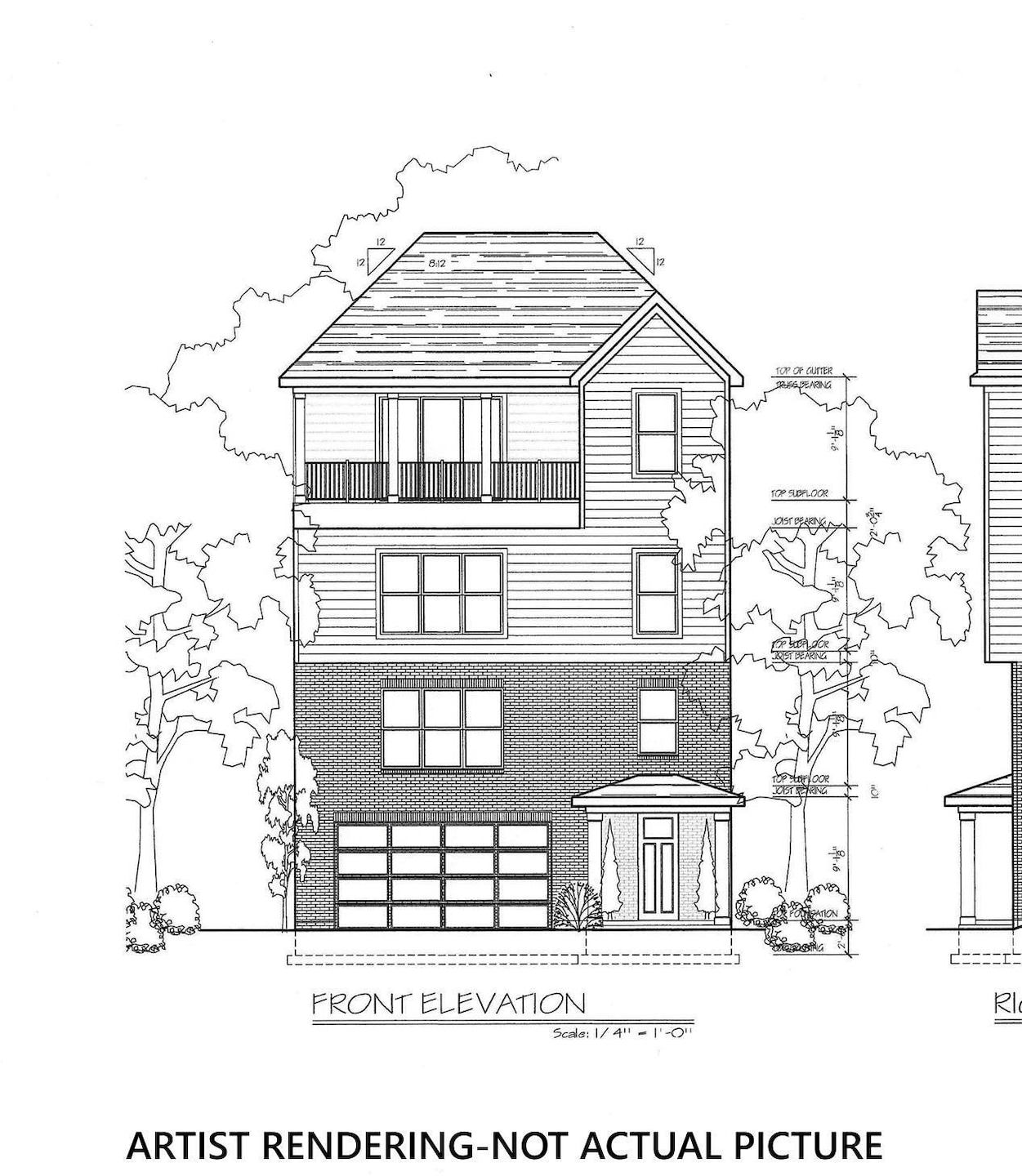
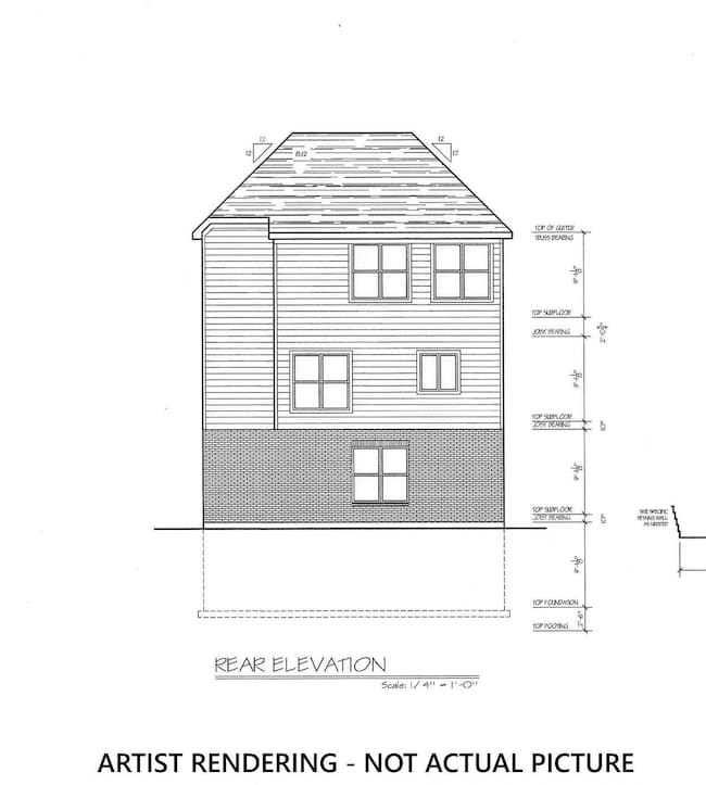
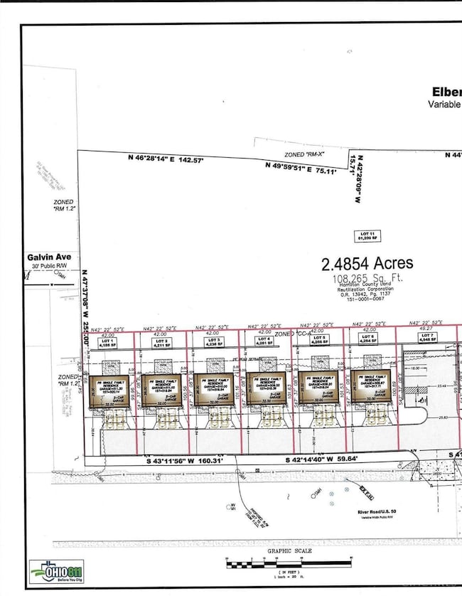
Get in one step above the ground floor of The Gateway of River Bend development. This project is approved and ready for someone to purchase this land and the accompanying engineering and hit the ground running with the development followed by construction of 9 single family lots with great River and City views. Concept house plans are included in this price or let your imagination take over and come up with the perfect house design. Should that first development go as we think it will there is another parcel just above this one with the concept being to have 9 more single family lots. This project is just waiting for the right company to buy in and get it going. In our experience in getting the project to this point the City has been very supportive of the plans but other uses are certainly a possibility. Stop out and take a look, we know you can make this parcel the showplace that it deserves to be.
Listing Agent
Joan Elflein
Ohio Broker Direct License #0000386319 Listed on: 12/01/2025
Property Details
Property Type
- Land
Est. Annual Taxes
- $153
Lot Details
- 1.07 Acre Lot
- Partially Wooded Lot
Property Views
- River
- City
Utilities
- Gas Available at Street
- Sewer in Street
Community Details
- No Home Owners Association
Map
Home Values in the Area
Average Home Value in this Area
Tax History
| Year | Tax Paid | Tax Assessment Tax Assessment Total Assessment is a certain percentage of the fair market value that is determined by local assessors to be the total taxable value of land and additions on the property. | Land | Improvement |
|---|---|---|---|---|
| 2024 | $153 | $18,942 | $18,942 | -- |
| 2023 | $0 | $18,942 | $18,942 | $0 |
| 2022 | $0 | $18,942 | $18,942 | $0 |
| 2021 | $1,636 | $18,942 | $18,942 | $0 |
| 2020 | $1,636 | $18,942 | $18,942 | $0 |
| 2019 | $696 | $18,942 | $18,942 | $0 |
| 2018 | $14,959 | $18,942 | $18,942 | $0 |
| 2017 | $15,245 | $18,942 | $18,942 | $0 |
| 2016 | $18,744 | $61,510 | $59,896 | $1,614 |
| 2015 | $19,174 | $61,510 | $59,896 | $1,614 |
| 2014 | $23,443 | $99,541 | $39,645 | $59,896 |
| 2013 | $9,223 | $103,688 | $41,297 | $62,391 |
Property History
| Date | Event | Price | List to Sale | Price per Sq Ft |
|---|---|---|---|---|
| 12/01/2025 12/01/25 | For Sale | $420,000 | -6.7% | -- |
| 12/01/2025 12/01/25 | For Sale | $450,000 | -- | -- |
Purchase History
| Date | Type | Sale Price | Title Company |
|---|---|---|---|
| Special Warranty Deed | -- | None Listed On Document | |
| Public Action Common In Florida Clerks Tax Deed Or Tax Deeds Or Property Sold For Taxes | -- | None Available | |
| Warranty Deed | $350,000 | -- |
Mortgage History
| Date | Status | Loan Amount | Loan Type |
|---|---|---|---|
| Previous Owner | $330,000 | Seller Take Back |
Source: MLS of Greater Cincinnati (CincyMLS)
MLS Number: 1863008
APN: 151-0001-0067
Disclaimer: Certain information contained herein is derived from information provided by parties other than Homes.com. All information provided is deemed reliable, but is not guaranteed to be accurate and should be independently verified.
![]() The data relating to real estate for sale on this website comes in part from the Broker Reciprocity programs of the MLS of Greater Cincinnati, Inc.. Those listings held by brokerage firms other than Ten-X are marked with the Broker Reciprocity logo and house icon. The properties displayed may not be all of the properties available through Broker Reciprocity.
The data relating to real estate for sale on this website comes in part from the Broker Reciprocity programs of the MLS of Greater Cincinnati, Inc.. Those listings held by brokerage firms other than Ten-X are marked with the Broker Reciprocity logo and house icon. The properties displayed may not be all of the properties available through Broker Reciprocity.
IDX information is provided exclusively for personal, non-commercial use, and may not be used for any purpose other than to identify prospective properties consumers may be interested in purchasing.
Information is deemed reliable but not guaranteed.
Ten-X does not display the entire Cincinnati MLS Broker Reciprocity™ database on this web site. The listings of some real estate brokerage firms have been excluded.
Copyright 2025, MLS of Greater Cincinnati, Inc. All rights reserved
- 2450 River Rd
- 2403 Elberon Ave
- 2462 River Rd
- 490 Mt Hope Ave
- 542 Davenport Ave
- 2347 Maryland Ave
- 309 Mount Hope Ave
- 456 Grand Ave
- 454 Grand Ave
- 677 State Ave
- 452 Grand Ave
- 2354 Warsaw Ave
- 2392 Maryland Ave
- 2152 Staebler St
- 2624 River Rd
- 602 Hawthorne Ave
- 432 Hawthorne Ave
- 389 Grand Ave
- 2617 Eighth St W
- 658 Hawthorne Ave
- 2454 River Rd Unit 2
- 2311 Maryland Ave Unit C
- 558 Davenport Ave
- 2415 Maryland Ave
- 2415 Maryland Ave
- 810 Matson Place
- 355 Grand Ave
- 760 Chateau Ave
- 318 Purcell Ave
- 8 Carneal St
- 35 Ash St Unit a
- 550 Fairbanks Ave
- 1014 Parkson Place
- 1247 State Ave
- 344 Eastview Ct Unit 1102
- 459 Pinnacle Way Unit 9202
- 1023 Carson Ave
- 868 Academy Ave Unit 868 Academy Avenue, Cincinnati OH. 45205
- 3968 W 8th St Unit 3968 w 8th Loft
- 1273 Quebec Rd
