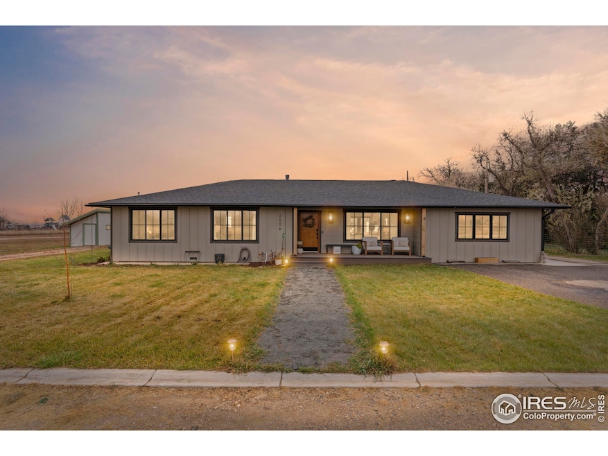
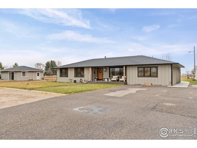
2506 Suncrest Dr Loveland, CO 80537
Estimated payment $6,990/month
Highlights
- Parking available for a boat
- Spa
- 2.5 Acre Lot
- Carrie Martin Elementary School Rated 9+
- City View
- Open Floorplan
About This Home
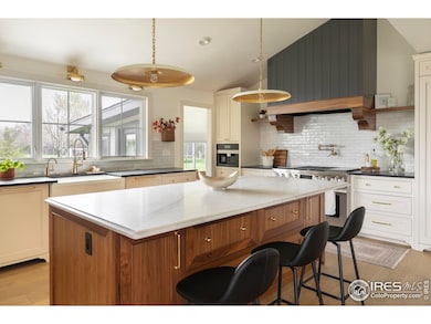
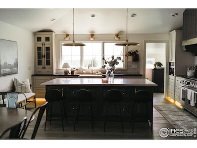
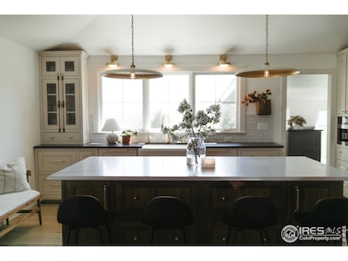
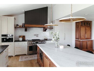
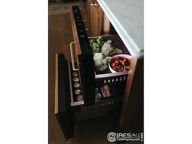
This is your chance to own a former Hutch Design Build show home-beautifully crafted, fully remodeled in 2022, and set on 2.5 acres with an exceptional combination of luxury, privacy, and multi-generational potential. The property includes a 2,800 sq ft main residence plus a 720 sq ft ADU/Carriage House, ideal for guests, extended family, or multi gen living. As a past show home, the main house is filled with premium finishes and custom details throughout. The primary suite features a steam shower, slipper-foot soaking tub, and detailed tilework that continues through every bathroom. Rich hardwood floors anchor the main living spaces, and the craftsmanship is evident in every room.The kitchen is a standout centerpiece, designed for serious cooking and effortless entertaining. It offers custom inset cabinetry, a blend of Soapstone and Quartz counters, a high-end range with induction and sous-vide station, two dishwashers, and under-counter refrigerator drawers.Outside, the property is equally impressive. A 1,106 sq ft shop includes three oversized garage doors and concrete floors-perfect for vehicles, hobby space, or storage. Additional sheds, chicken coops, and a large storage building/barn (with conversion potential for additional garage space) provide outstanding versatility. The land setup supports horses; please confirm allowable livestock numbers with the county.The oversized back patio is positioned to capture peaceful sunrises, and the included hot tub makes it a comfortable year-round retreat. In the evenings, the front porch and living room offer stunning sunset views over the foothills.Although the setting feels quiet and rural, the home is just minutes from town conveniences-an ideal blend of privacy and accessibility.A rare opportunity to own a high-end, fully updated country property with room to spread out and the flexibility for multi-generational living. More Photos Coming Soon
Home Details
Home Type
- Single Family
Est. Annual Taxes
- $3,945
Year Built
- Built in 1971
Lot Details
- 2.5 Acre Lot
- Dirt Road
- Partially Fenced Property
- Property is zoned FA
Parking
- 3 Car Detached Garage
- Parking available for a boat
Home Design
- Carriage House
- Wood Frame Construction
- Composition Roof
Interior Spaces
- 3,526 Sq Ft Home
- 1-Story Property
- Open Floorplan
- Beamed Ceilings
- Wood Flooring
- City Views
- Fire and Smoke Detector
Kitchen
- Gas Oven or Range
- Microwave
- Dishwasher
- Kitchen Island
- Disposal
Bedrooms and Bathrooms
- 4 Bedrooms
- Walk-In Closet
- In-Law or Guest Suite
- Freestanding Bathtub
- Soaking Tub
- Steam Shower
Laundry
- Dryer
- Washer
Accessible Home Design
- Garage doors are at least 85 inches wide
Outdoor Features
- Spa
- Patio
- Outdoor Storage
Schools
- Carrie Martin Elementary School
- Bill Reed Middle School
- Thompson Valley High School
Utilities
- Forced Air Heating and Cooling System
- Septic System
Community Details
- No Home Owners Association
Listing and Financial Details
- Assessor Parcel Number R0451908
Map
Home Values in the Area
Average Home Value in this Area
Tax History
| Year | Tax Paid | Tax Assessment Tax Assessment Total Assessment is a certain percentage of the fair market value that is determined by local assessors to be the total taxable value of land and additions on the property. | Land | Improvement |
|---|---|---|---|---|
| 2025 | $3,945 | $52,126 | $3,645 | $48,481 |
| 2024 | $3,807 | $52,126 | $3,645 | $48,481 |
| 2022 | $2,603 | $33,020 | $3,781 | $29,239 |
| 2021 | $2,672 | $33,970 | $3,890 | $30,080 |
| 2020 | $2,502 | $31,811 | $3,890 | $27,921 |
| 2019 | $2,459 | $31,811 | $3,890 | $27,921 |
| 2018 | $2,319 | $28,462 | $3,917 | $24,545 |
| 2017 | $1,996 | $28,462 | $3,917 | $24,545 |
| 2016 | $1,875 | $25,854 | $4,330 | $21,524 |
| 2015 | $1,859 | $25,850 | $4,330 | $21,520 |
| 2014 | $1,585 | $21,320 | $4,330 | $16,990 |
Property History
| Date | Event | Price | List to Sale | Price per Sq Ft |
|---|---|---|---|---|
| 11/22/2025 11/22/25 | For Sale | $1,265,000 | -- | $359 / Sq Ft |
Purchase History
| Date | Type | Sale Price | Title Company |
|---|---|---|---|
| Special Warranty Deed | $756,000 | None Listed On Document | |
| Interfamily Deed Transfer | -- | None Available | |
| Interfamily Deed Transfer | -- | None Available | |
| Interfamily Deed Transfer | -- | None Available | |
| Deed | $70,000 | -- |
Mortgage History
| Date | Status | Loan Amount | Loan Type |
|---|---|---|---|
| Closed | $567,000 | Construction |
Source: IRES MLS
MLS Number: 1047654
APN: 95283-00-028
Disclaimer: Certain information contained herein is derived from information provided by parties other than Homes.com. All information provided is deemed reliable, but is not guaranteed to be accurate and should be independently verified.
![]() Information source: Information and Real Estate Services, LLC. Provided for limited non-commercial use only under IRES Rules © Copyright IRES.
Information source: Information and Real Estate Services, LLC. Provided for limited non-commercial use only under IRES Rules © Copyright IRES.
Listing information is provided exclusively for consumers' personal, non-commercial use and may not be used for any purpose other than to identify prospective properties consumers may be interested in purchasing.
Information deemed reliable but not guaranteed by the MLS.
- 0 Tbd Unit RECIR1004964
- 2808 Sally Ann Dr
- 2828 Mango Place
- 1168 Blue Agave Ct
- 1158 Blue Agave Ct
- 2720 Mallow Place
- 1656 S Gilpin Ave
- 1750 S Estrella Ave
- 1167 Cynthia Ct
- 1028 Cynthia Ct
- 781 Johnson Ave
- 1853 14th St SW
- 2804 Chickaree Place SW
- 874 S Buckeye Dr
- 511 Marcellina Dr
- 974 S Dotsero Dr
- 450 Wapola Ave
- 428 Candelaria Dr
- 2821 5th St SW
- 1601 14th St SW
- 1459 Cattail Dr
- 1416-1422 S Dotsero Dr Unit 1416
- 1430 S Tyler Ave
- 805 Heather Dr
- 1600 S Taft St
- 701 S Tyler St
- 348 Terri Dr Unit 3
- 1415-1485 10th St SW
- 832 21st St SW
- 1120 W County Road 14
- 5047 St Andrews Dr
- 1391 N Wilson Ave
- 2871 Urban Place Unit A
- 1020 Cimmeron Dr
- 444 N Custer Ave
- 2150 W 15th St
- 2480 Barela Dr
- 1751 Wilson Ave
- 4225 Hawg Wild Rd
- 451 14th St SE
