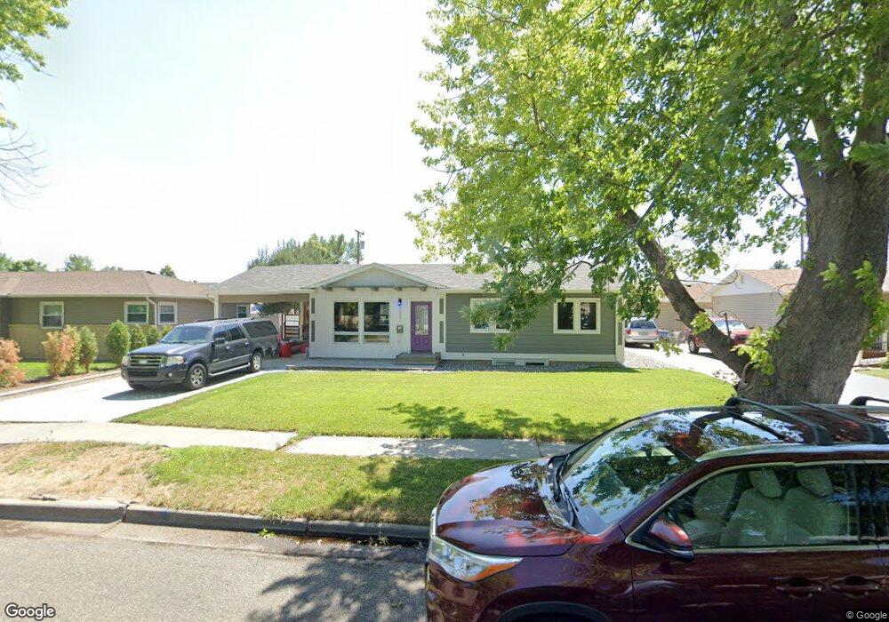
2632 Cook Ave Billings, MT 59102
West End NeighborhoodEstimated Value: $322,000 - $332,200
4
Beds
2
Baths
1,092
Sq Ft
$298/Sq Ft
Est. Value
About This Home
This home is located at 2632 Cook Ave, Billings, MT 59102 and is currently estimated at $325,550, approximately $298 per square foot. 2632 Cook Ave is a home located in Yellowstone County with nearby schools including Meadowlark School, Will James Junior High School, and Billings West High School.
Ownership History
Date
Name
Owned For
Owner Type
Purchase Details
Closed on
Feb 21, 2025
Sold by
Johnson Loren and Johnson Brett M
Bought by
Johnson Loren
Current Estimated Value
Home Financials for this Owner
Home Financials are based on the most recent Mortgage that was taken out on this home.
Original Mortgage
$181,000
Outstanding Balance
$179,951
Interest Rate
7.04%
Mortgage Type
New Conventional
Estimated Equity
$145,599
Purchase Details
Closed on
Oct 17, 2013
Sold by
Dorsey Patricia
Bought by
Johnson Loren and Johnson Brett M
Home Financials for this Owner
Home Financials are based on the most recent Mortgage that was taken out on this home.
Original Mortgage
$100,000
Interest Rate
4.55%
Mortgage Type
New Conventional
Purchase Details
Closed on
Feb 24, 2009
Sold by
Dorsey Suzanne A
Bought by
Dorsey Suzanne A and Dorsey Patricia A
Create a Home Valuation Report for This Property
The Home Valuation Report is an in-depth analysis detailing your home's value as well as a comparison with similar homes in the area
Home Values in the Area
Average Home Value in this Area
Purchase History
| Date | Buyer | Sale Price | Title Company |
|---|---|---|---|
| Johnson Loren | -- | Stewart Title Company | |
| Johnson Loren | -- | None Available | |
| Johnson Loren | -- | None Available | |
| Dorsey Suzanne A | -- | None Available |
Source: Public Records
Mortgage History
| Date | Status | Borrower | Loan Amount |
|---|---|---|---|
| Open | Johnson Loren | $181,000 | |
| Previous Owner | Johnson Loren | $100,000 |
Source: Public Records
Tax History
| Year | Tax Paid | Tax Assessment Tax Assessment Total Assessment is a certain percentage of the fair market value that is determined by local assessors to be the total taxable value of land and additions on the property. | Land | Improvement |
|---|---|---|---|---|
| 2025 | $2,920 | $321,100 | $46,761 | $274,339 |
| 2024 | $2,920 | $292,100 | $46,849 | $245,251 |
| 2023 | $2,920 | $292,100 | $46,849 | $245,251 |
| 2022 | $2,496 | $217,900 | $0 | $0 |
| 2021 | $2,376 | $217,900 | $0 | $0 |
| 2020 | $2,420 | $212,100 | $0 | $0 |
| 2019 | $2,317 | $212,100 | $0 | $0 |
| 2018 | $2,215 | $198,100 | $0 | $0 |
| 2017 | $2,156 | $198,100 | $0 | $0 |
| 2016 | $1,929 | $177,100 | $0 | $0 |
| 2015 | $1,888 | $177,100 | $0 | $0 |
| 2014 | $1,719 | $85,065 | $0 | $0 |
Source: Public Records
Map
Nearby Homes
- 2521 Custer Ave
- 2930 Lynn Ave
- 0 Wyatt Cir Unit 356590
- 2 Mcbride St
- 371 W Daffodil Dr
- 2300 Clark Ave
- 3136 Saint Johns Ave
- 3142 Saint Johns Ave
- 2826 Oakland Dr Unit 11
- 1125 30th St W
- 3203 Lynn Ave
- 3214 Lynn Ave
- 3220 Lynn Ave
- 98 Cache Dr
- 2550 Forest Meadow Ln
- 10 Prairie View Dr
- 0 Broadwater Ave Unit 357292
- 3334 Winchell Ln
- 2434 Avenue B
- 370 Delta Cir
- 2626 Cook Ave
- 2638 Cook Ave
- 2620 Cook Ave
- 2642 Cook Ave
- 2631 Cook Ave
- 2637 Cook Ave
- 2625 Cook Ave
- 2631 Saint Johns Ave
- 2616 Cook Ave
- 2646 Cook Ave
- 2619 St Johns Ave - Lease
- 2619 St Johns Ave (Lease)
- 2641 Cook Ave
- 2619 Cook Ave
- 2610 Cook Ave
- 2645 Cook Ave
- 2615 Cook Ave
- 2626 Howard Ave
- 2622 Howard Ave
- 2632 Howard Ave
Your Personal Tour Guide
Ask me questions while you tour the home.