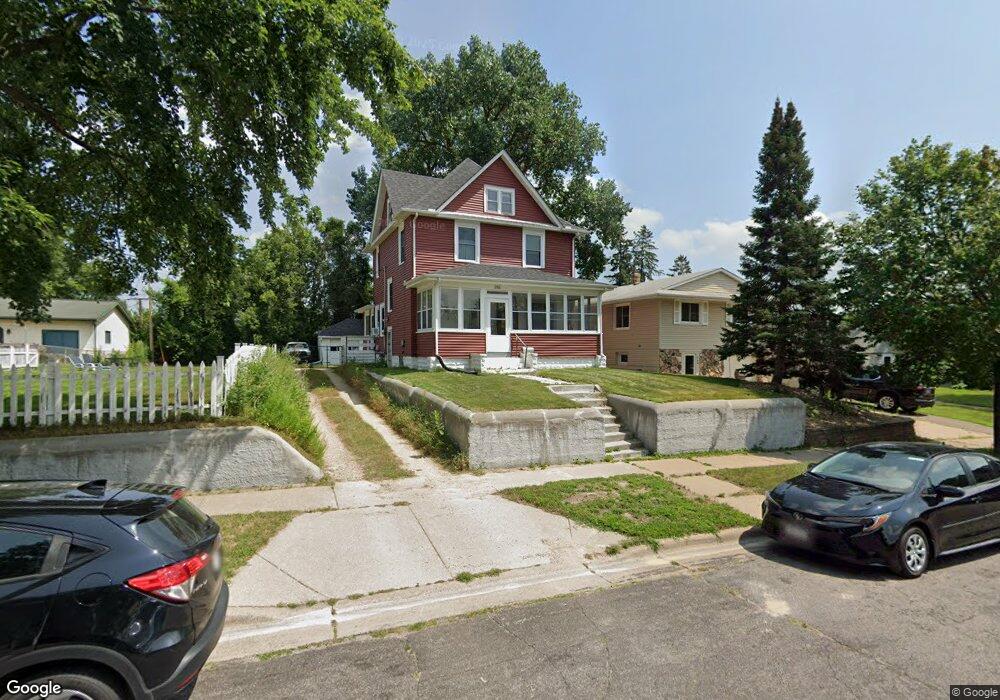
266 Clarence St Saint Paul, MN 55106
Dayton's Bluff NeighborhoodEstimated Value: $261,000 - $291,000
3
Beds
1
Bath
1,426
Sq Ft
$192/Sq Ft
Est. Value
About This Home
This home is located at 266 Clarence St, Saint Paul, MN 55106 and is currently estimated at $274,403, approximately $192 per square foot. 266 Clarence St is a home located in Ramsey County with nearby schools including Highwood Hills Elementary School, Battle Creek Middle School, and Harding Senior High School.
Ownership History
Date
Name
Owned For
Owner Type
Purchase Details
Closed on
Nov 15, 2007
Sold by
Wells Fargo Bank Na
Bought by
Harvang Ole T
Current Estimated Value
Purchase Details
Closed on
Oct 5, 2000
Sold by
Harvang Ole T and Harvang Michelle
Bought by
Fitzgerald Joshua J and Fitzgerald Laura M
Purchase Details
Closed on
Oct 25, 1996
Sold by
Merrell Brenda A
Bought by
Harvang Ole T
Create a Home Valuation Report for This Property
The Home Valuation Report is an in-depth analysis detailing your home's value as well as a comparison with similar homes in the area
Home Values in the Area
Average Home Value in this Area
Purchase History
| Date | Buyer | Sale Price | Title Company |
|---|---|---|---|
| Harvang Ole T | $92,000 | -- | |
| Fitzgerald Joshua J | $119,900 | -- | |
| Harvang Ole T | $74,000 | -- |
Source: Public Records
Tax History Compared to Growth
Tax History
| Year | Tax Paid | Tax Assessment Tax Assessment Total Assessment is a certain percentage of the fair market value that is determined by local assessors to be the total taxable value of land and additions on the property. | Land | Improvement |
|---|---|---|---|---|
| 2025 | $3,382 | $241,100 | $45,100 | $196,000 |
| 2023 | $3,382 | $218,400 | $28,900 | $189,500 |
| 2022 | $3,034 | $217,100 | $28,900 | $188,200 |
| 2021 | $2,574 | $187,200 | $28,900 | $158,300 |
| 2020 | $2,682 | $165,400 | $28,900 | $136,500 |
| 2019 | $2,424 | $161,600 | $28,900 | $132,700 |
| 2018 | $2,366 | $145,500 | $28,900 | $116,600 |
| 2017 | $2,668 | $127,000 | $28,900 | $98,100 |
| 2016 | $2,632 | $0 | $0 | $0 |
| 2015 | $2,372 | $106,100 | $25,300 | $80,800 |
| 2014 | $2,202 | $0 | $0 | $0 |
Source: Public Records
Map
Nearby Homes
- 277 English St
- 1320 Wilson Ave
- 1526 Upper Afton Rd
- 449 Birmingham St
- 426 Griffith St
- 1549 Old Hudson Rd
- 1574 Pacific St
- 1591 Old Hudson Rd
- 1063 Burns Ave
- 1183 Hancock St
- 1323 4th St E
- 3 Kennard Ct
- 1631 Conway St
- 1237 5th St E
- 1207 5th St E
- 1747 Louise Ave
- 1201 6th St E
- 986 Euclid St
- 1122 6th St E
- 1685 Fremont Ave
- 272 Clarence St
- 264 Clarence St
- 278 Clarence St
- 260 Clarence St
- 282 Clarence St
- 1365 Burns Ave
- 286 Clarence St
- 244 244 Point Douglas-Road-n
- 1367 Burns Ave
- 271 Clarence St
- 244 Point Douglas Rd N
- 275 Clarence St
- 292 Clarence St
- 279 Clarence St
- 283 Clarence St
- 294 Clarence St
- 1377 Burns Ave
- 1379 Burns Ave
- 1373 Burns Ave
- 287 Clarence St