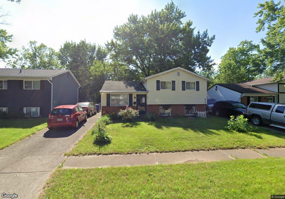
2715 Mellowbrook St Columbus, OH 43232
Walnut Heights NeighborhoodEstimated Value: $182,048 - $248,000
3
Beds
2
Baths
966
Sq Ft
$225/Sq Ft
Est. Value
About This Home
This home is located at 2715 Mellowbrook St, Columbus, OH 43232 and is currently estimated at $217,012, approximately $224 per square foot. 2715 Mellowbrook St is a home located in Franklin County with nearby schools including Liberty Elementary School, Yorktown Middle School, and Independence High School.
Ownership History
Date
Name
Owned For
Owner Type
Purchase Details
Closed on
Dec 21, 1992
Bought by
Posten Philip A and Posten Mary A
Current Estimated Value
Create a Home Valuation Report for This Property
The Home Valuation Report is an in-depth analysis detailing your home's value as well as a comparison with similar homes in the area
Home Values in the Area
Average Home Value in this Area
Purchase History
| Date | Buyer | Sale Price | Title Company |
|---|---|---|---|
| Posten Philip A | $55,000 | -- |
Source: Public Records
Tax History
| Year | Tax Paid | Tax Assessment Tax Assessment Total Assessment is a certain percentage of the fair market value that is determined by local assessors to be the total taxable value of land and additions on the property. | Land | Improvement |
|---|---|---|---|---|
| 2025 | $2,501 | $55,730 | $16,980 | $38,750 |
| 2024 | $2,501 | $55,730 | $16,980 | $38,750 |
| 2023 | $2,469 | $55,720 | $16,975 | $38,745 |
| 2022 | $1,445 | $27,860 | $5,250 | $22,610 |
| 2021 | $1,448 | $27,860 | $5,250 | $22,610 |
| 2020 | $1,449 | $27,860 | $5,250 | $22,610 |
| 2019 | $1,410 | $23,250 | $4,380 | $18,870 |
| 2018 | $1,337 | $23,250 | $4,380 | $18,870 |
| 2017 | $1,403 | $23,250 | $4,380 | $18,870 |
| 2016 | $1,396 | $21,070 | $3,640 | $17,430 |
| 2015 | $1,267 | $21,070 | $3,640 | $17,430 |
| 2014 | $1,270 | $21,070 | $3,640 | $17,430 |
| 2013 | $695 | $23,380 | $4,025 | $19,355 |
Source: Public Records
Map
Nearby Homes
- 2706 Moundcrest St
- 2737 Raphael Dr
- 2730 Raphael Dr
- 2700 Raphael Dr
- 5278 Glenbriar Ct
- 2651 Brownfield Rd
- 2736 Barrows Rd
- 2744 Barrows Rd
- 2608 Hubbell Rd
- 5326 Adderley Ave
- 5414 Paladim Rd
- 5137 Holbrook Dr
- 5084 Refugee Rd
- 5114 Carbondale Dr
- 5373 Spire Ln
- 5290 Quincy Dr
- 5123 Jameson Dr
- 2998 Osgood Rd E
- 2706 Maywood Rd
- 2949 Fleet Rd
- 2721 Mellowbrook St
- 2709 Mellowbrook St
- 2729 Mellowbrook St
- 2701 Mellowbrook St
- 2710 Moundcrest St
- 2718 Moundcrest St
- 2693 Mellowbrook St
- 2735 Mellowbrook St
- 2692 Moundcrest St
- 2718 Mellowbrook St
- 2724 Moundcrest St
- 5421 Mellowbrook Ct
- 2724 Mellowbrook St
- 2687 Mellowbrook St
- 2730 Mellowbrook St
- 2730 Moundcrest St
- 2743 Mellowbrook St
- 2738 Mellowbrook St
- 2684 Mellowbrook St
- 2684 Moundcrest St