275 Petersham Rd Phillipston, MA 01331
Estimated payment $4,454/month
Highlights
- Community Stables
- 3.51 Acre Lot
- Wood Burning Stove
- Barn or Stable
- Colonial Architecture
- Cathedral Ceiling
About This Home
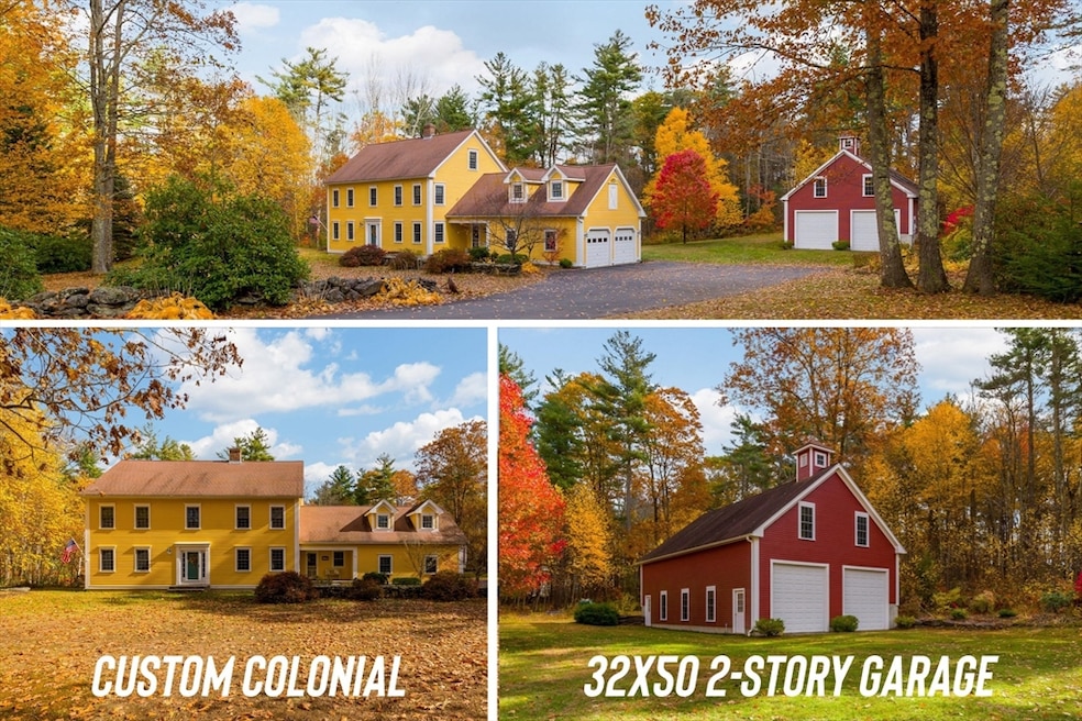
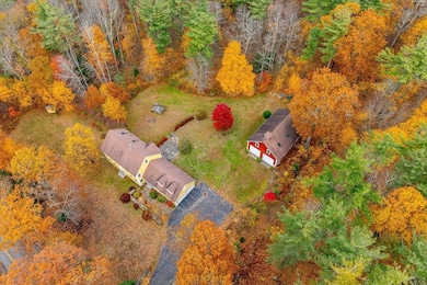
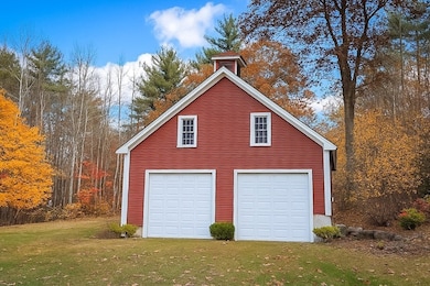
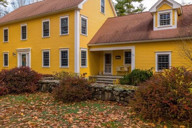
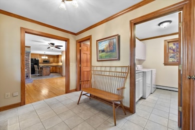
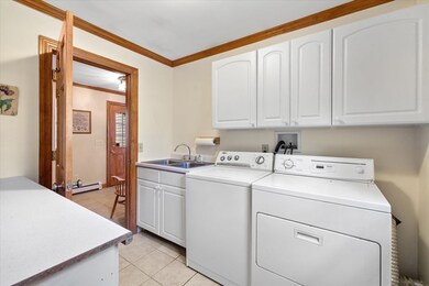
Car lovers, contractors & hobbyists—your dream property awaits! The heated 32x50 barn is built for serious work & play, featuring oversized 11’ doors & 12' ceilings—ideal for lifts, trucks, boats & RVs. It has its own 200A svc, H2O & heat, plus a finished 2nd-flr w/ kitchenette, bar, pool table & lounge—perfect for entertaining, office or future in-law/ADU (cart rd for sep drive/parking). The barn’s layout easily fits multiple vehicles, tools & equipment for work or recreation. The custom Colonial showcases fine craftsmanship w/ rich woodwork, crown molding & Glenwood cabinets. Main level offers formal LR & DR, den w/ woodstove, 1st-flr office, spacious kitchen & mudrm/laundry w/ access to att 2-car gar w/ bonus rm above—great for gym, studio or rec space. Upstairs features a front-to-back primary suite w/ walk-in closet & bath, plus 2 BRs—one connects to the rm above gar for a perfect teen suite. Includes a creative rm for crafts or nursery & a full walk-up 3rd fl ready to finish
Home Details
Home Type
- Single Family
Est. Annual Taxes
- $6,887
Year Built
- Built in 2000
Lot Details
- 3.51 Acre Lot
- Stone Wall
- Gentle Sloping Lot
- Garden
- Property is zoned RA
Parking
- 4 Car Garage
- Heated Garage
- Side Facing Garage
- Garage Door Opener
- Driveway
- Open Parking
- Off-Street Parking
Home Design
- Colonial Architecture
- Frame Construction
- Shingle Roof
- Concrete Perimeter Foundation
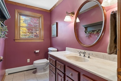
Interior Spaces
- 2,975 Sq Ft Home
- Wet Bar
- Central Vacuum
- Wired For Sound
- Crown Molding
- Cathedral Ceiling
- Wood Burning Stove
- French Doors
- Mud Room
- Home Office
- Bonus Room
- Play Room
- Washer and Electric Dryer Hookup
- Attic
Kitchen
- Range
- Microwave
- Dishwasher
- Kitchen Island
- Solid Surface Countertops
Flooring
- Wood
- Ceramic Tile
Bedrooms and Bathrooms
- 4 Bedrooms
- Primary bedroom located on second floor
- Walk-In Closet
Unfinished Basement
- Walk-Out Basement
- Basement Fills Entire Space Under The House
- Interior Basement Entry
- Block Basement Construction
Outdoor Features
- Patio
- Outdoor Storage
- Rain Gutters
- Porch
Farming
- Barn or Stable
Utilities
- No Cooling
- Heating System Uses Oil
- Pellet Stove burns compressed wood to generate heat
- Radiant Heating System
- Baseboard Heating
- 200+ Amp Service
- 100 Amp Service
- Private Water Source
- Private Sewer
Listing and Financial Details
- Assessor Parcel Number M:00015 L:0001D,3792048
Community Details
Overview
- No Home Owners Association
Recreation
- Community Stables
- Jogging Path
Map
Home Values in the Area
Average Home Value in this Area
Tax History
| Year | Tax Paid | Tax Assessment Tax Assessment Total Assessment is a certain percentage of the fair market value that is determined by local assessors to be the total taxable value of land and additions on the property. | Land | Improvement |
|---|---|---|---|---|
| 2025 | $6,887 | $611,100 | $53,100 | $558,000 |
| 2024 | $6,917 | $577,400 | $48,000 | $529,400 |
| 2023 | $6,692 | $521,200 | $48,000 | $473,200 |
| 2022 | $6,975 | $447,700 | $36,800 | $410,900 |
| 2021 | $6,710 | $416,500 | $36,800 | $379,700 |
| 2020 | $6,422 | $379,100 | $36,800 | $342,300 |
| 2018 | $5,883 | $357,000 | $36,000 | $321,000 |
| 2017 | $5,711 | $342,400 | $36,000 | $306,400 |
| 2016 | $5,523 | $327,000 | $36,000 | $291,000 |
Property History
| Date | Event | Price | List to Sale | Price per Sq Ft |
|---|---|---|---|---|
| 10/29/2025 10/29/25 | For Sale | $739,900 | -- | $249 / Sq Ft |
Purchase History
| Date | Type | Sale Price | Title Company |
|---|---|---|---|
| Deed | -- | -- | |
| Deed | $22,000 | -- |
Mortgage History
| Date | Status | Loan Amount | Loan Type |
|---|---|---|---|
| Previous Owner | $177,000 | No Value Available | |
| Previous Owner | $146,000 | No Value Available |
Source: MLS Property Information Network (MLS PIN)
MLS Number: 73448935
APN: PHIL M:00015 L:0001D
Disclaimer: Certain information contained herein is derived from information provided by parties other than Homes.com. All information provided is deemed reliable, but is not guaranteed to be accurate and should be independently verified.
![]() The property listing data and information, or the Images, set forth herein were provided to MLS Property Information Network, Inc. from third party sources, including sellers, lessors and public records, and were compiled by MLS Property Information Network, Inc. The property listing data and information, and the Images, are for the personal, non-commercial use of consumers having a good faith interest in purchasing or leasing listed properties of the type displayed to them and may not be used for any purpose other than to identify prospective properties which such consumers may have a good faith interest in purchasing or leasing. MLS Property Information Network, Inc. and its subscribers disclaim any and all representations and warranties as to the accuracy of the property listing data and information, or as to the accuracy of any of the Images, set forth herein.
The property listing data and information, or the Images, set forth herein were provided to MLS Property Information Network, Inc. from third party sources, including sellers, lessors and public records, and were compiled by MLS Property Information Network, Inc. The property listing data and information, and the Images, are for the personal, non-commercial use of consumers having a good faith interest in purchasing or leasing listed properties of the type displayed to them and may not be used for any purpose other than to identify prospective properties which such consumers may have a good faith interest in purchasing or leasing. MLS Property Information Network, Inc. and its subscribers disclaim any and all representations and warranties as to the accuracy of the property listing data and information, or as to the accuracy of any of the Images, set forth herein.
- 420 Queen Lake Rd
- 225 Queen Lake Rd
- 240 Barre Rd
- 0 Popple Camp Rd Unit 73432026
- 40 Burnshirt Rd
- 27 Popple Camp Rd
- 204 East St
- 47 Harty Dr
- 0 Williamsville Rd
- lot 53 Secret Lake Rd
- Lot 4 Highland Ave
- Lot 6 Highland Ave
- 15 Common St
- 102 Lyons Hill Rd
- 171 South Rd
- 14 Baldwinville Rd
- 0 Hubbardston Rd Unit 73407169
- 28 Spring St
- 00 Miles Rd
- 35 West St
- 6 Exchange St Unit A
- 129 Union St
- 232 Pequoig Ave Unit 2
- 9 Mount Pleasant St
- 9 Mount Pleasant St
- 14 Coleman St Unit 2
- 40 Moran St
- 88 Baker St
- 33 Ash St Unit 1
- 16 Oriole St Unit 4
- 19 Franklin Ct Unit 3R
- 19 Franklin Ct Unit 1R
- 168 Oak St Unit 1
- 14 Richmond St Unit 1
- 250 Pine St Unit 3
- 142 Washington St Unit 2
- 120 Grant St Unit 2
- 19 Lincoln St Unit 2
- 419 E River St
- 331-333 E Main St Unit 333
