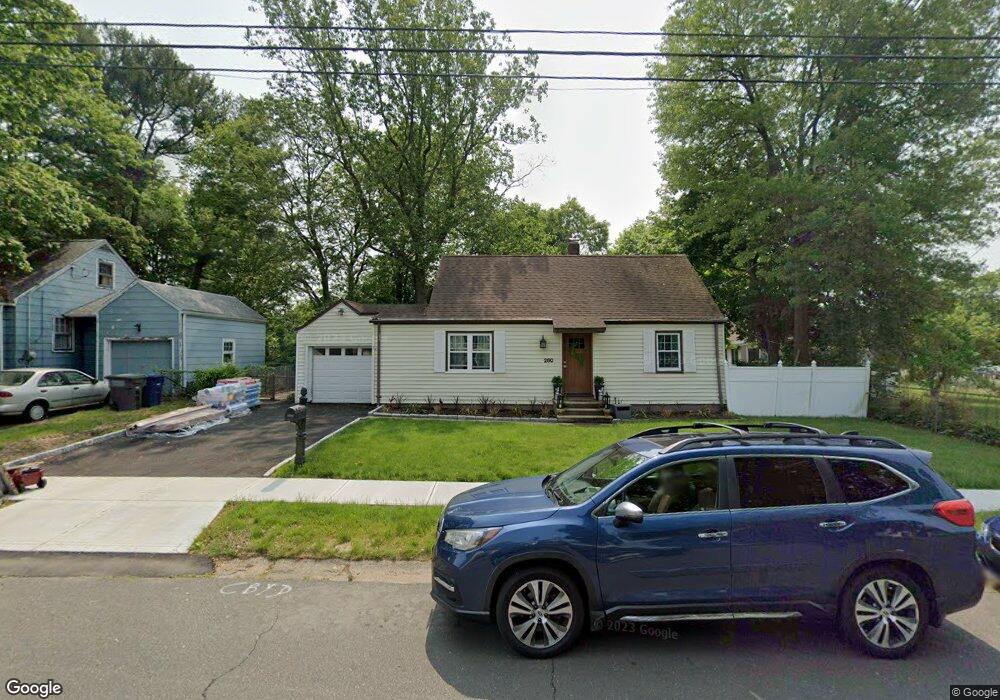
280 Hooker Rd Bridgeport, CT 06610
North Bridgeport NeighborhoodEstimated Value: $336,000 - $407,545
3
Beds
2
Baths
1,411
Sq Ft
$257/Sq Ft
Est. Value
About This Home
This home is located at 280 Hooker Rd, Bridgeport, CT 06610 and is currently estimated at $362,136, approximately $256 per square foot. 280 Hooker Rd is a home located in Fairfield County with nearby schools including Hooker School and Harding High School.
Ownership History
Date
Name
Owned For
Owner Type
Purchase Details
Closed on
Jan 6, 2022
Sold by
Romero Carmen D and Romero Julio
Bought by
Rodriguez Ricardo and Rodrigueaz Yessenia
Current Estimated Value
Purchase Details
Closed on
May 30, 1996
Sold by
Bennett Cornelius T
Bought by
Romero Carmen D and Romero Julio
Create a Home Valuation Report for This Property
The Home Valuation Report is an in-depth analysis detailing your home's value as well as a comparison with similar homes in the area
Home Values in the Area
Average Home Value in this Area
Purchase History
| Date | Buyer | Sale Price | Title Company |
|---|---|---|---|
| Rodriguez Ricardo | $270,000 | None Available | |
| Rodriguez Ricardo | $270,000 | None Available | |
| Romero Carmen D | $95,000 | -- | |
| Romero Carmen D | $95,000 | -- |
Source: Public Records
Mortgage History
| Date | Status | Borrower | Loan Amount |
|---|---|---|---|
| Previous Owner | Romero Carmen D | $192,850 | |
| Previous Owner | Romero Carmen D | $173,200 | |
| Previous Owner | Romero Carmen D | $147,000 |
Source: Public Records
Tax History
| Year | Tax Paid | Tax Assessment Tax Assessment Total Assessment is a certain percentage of the fair market value that is determined by local assessors to be the total taxable value of land and additions on the property. | Land | Improvement |
|---|---|---|---|---|
| 2025 | $6,203 | $142,760 | $65,700 | $77,060 |
| 2024 | $6,203 | $142,760 | $65,700 | $77,060 |
| 2023 | $6,203 | $142,760 | $65,700 | $77,060 |
| 2022 | $6,203 | $142,760 | $65,700 | $77,060 |
| 2021 | $6,203 | $142,760 | $65,700 | $77,060 |
| 2020 | $6,480 | $120,030 | $53,890 | $66,140 |
| 2019 | $6,480 | $120,030 | $53,890 | $66,140 |
| 2018 | $6,526 | $120,030 | $53,890 | $66,140 |
| 2017 | $6,526 | $120,030 | $53,890 | $66,140 |
| 2016 | $6,526 | $120,030 | $53,890 | $66,140 |
| 2015 | $6,288 | $149,000 | $52,650 | $96,350 |
| 2014 | $6,288 | $149,000 | $52,650 | $96,350 |
Source: Public Records
Map
Nearby Homes
- 3699 Broadbridge Ave Unit 330
- 3699 Broadbridge Ave Unit 101
- 11 Knollcrest Dr
- 119 Jennings Ave
- 120 Huntington Turnpike Unit 202
- 132 Virginia Ave Unit 132
- 211 Louisiana Ave Unit D
- 285 Hillcrest Rd
- 250 Dayton Rd
- 186 Louisiana Ave Unit D
- 11 Nob Hill Cir
- 261 Pennsylvania Ave
- 154 Virginia Ave Unit B
- 207 Hillcrest Rd
- 33 Louisiana Ave Unit 35
- 156 Dayton Rd
- 74 Hollywood Ave
- 72 Broadmere Rd
- 60 Quail Trail
- 9 Sunnyridge Pkwy
- 294 Hooker Rd
- 75 E Pasadena Place
- 310 Hooker Rd
- 283 Hooker Rd
- 261 Roger Williams Rd
- 243 Roger Williams Rd
- 39 E Pasadena Place
- 74 E Pasadena Place
- 297 Hooker Rd
- 230 Hooker Rd
- 289 Roger Williams Rd
- 322 Hooker Rd
- 315 Hooker Rd
- 305 Roger Williams Rd
- 102 E Pasadena Place
- 262 Roger Williams Rd
- 338 Hooker Rd
- 800 Huntington Turnpike
- 248 Roger Williams Rd
- 329 Hooker Rd
Your Personal Tour Guide
Ask me questions while you tour the home.