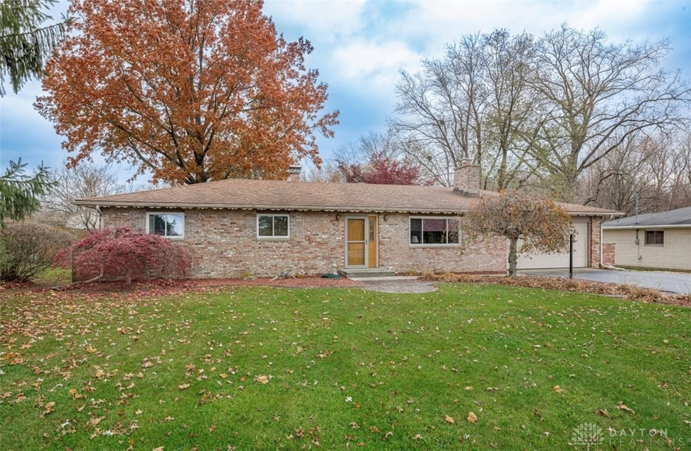


2866 State Route 122 Franklin, OH 45005
Estimated payment $1,680/month
Highlights
- 0.5 Acre Lot
- No HOA
- Bathroom on Main Level
- Dennis Elementary School Rated A-
- 2 Car Attached Garage
- Central Air
About This Home
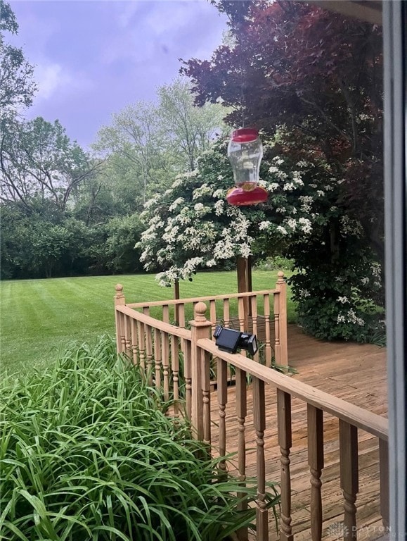
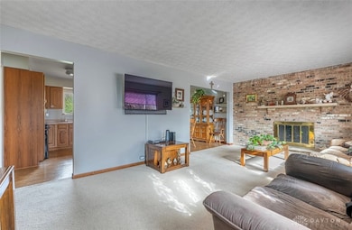
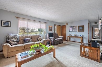
Welcome home to this charming 3 bedroom, 1.5 bath property located in desirable Clearcreek Township within the highly rated Springboro school district. This well maintained home offers a warm, inviting layout with upgraded electric and boxes for peace of mind. Enjoy a beautifully landscaped, private backyard-your own quiet retreat-featuring a spacious deck perfect for entertaining, relaxing, or outdoor dining. With its prime location, serene setting, and thoughtful improvements, this home is truly a must see!
Listing Agent
Coldwell Banker Heritage Brokerage Phone: (513) 424-2421 License #2018005813 Listed on: 11/18/2025

Home Details
Home Type
- Single Family
Est. Annual Taxes
- $2,670
Year Built
- 1969
Lot Details
- 0.5 Acre Lot
Parking
- 2 Car Attached Garage
Home Design
- Brick Exterior Construction
Interior Spaces
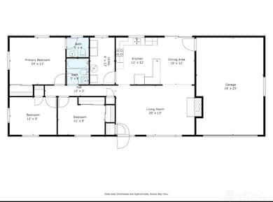
- 1,248 Sq Ft Home
- 1-Story Property
- Crawl Space
Bedrooms and Bathrooms
- 3 Bedrooms
- Bathroom on Main Level
Utilities
- Central Air
- Heating Available
Community Details
- No Home Owners Association
- Midvale Subdivision
Listing and Financial Details
- Assessor Parcel Number 08151520080
Map
Home Values in the Area
Average Home Value in this Area
Tax History
| Year | Tax Paid | Tax Assessment Tax Assessment Total Assessment is a certain percentage of the fair market value that is determined by local assessors to be the total taxable value of land and additions on the property. | Land | Improvement |
|---|---|---|---|---|
| 2024 | $2,670 | $65,300 | $23,100 | $42,200 |
| 2023 | $2,234 | $50,494 | $12,915 | $37,579 |
| 2022 | $2,234 | $50,495 | $12,915 | $37,580 |
| 2021 | $2,088 | $50,495 | $12,915 | $37,580 |
| 2020 | $1,947 | $41,052 | $10,500 | $30,552 |
| 2019 | $1,805 | $41,052 | $10,500 | $30,552 |
| 2018 | $1,794 | $41,052 | $10,500 | $30,552 |
| 2017 | $1,813 | $37,118 | $9,632 | $27,486 |
| 2016 | $1,886 | $37,118 | $9,632 | $27,486 |
| 2015 | $1,881 | $37,118 | $9,632 | $27,486 |
| 2014 | $1,792 | $33,440 | $8,680 | $24,760 |
| 2013 | $1,792 | $40,460 | $10,500 | $29,960 |
Property History
| Date | Event | Price | List to Sale | Price per Sq Ft |
|---|---|---|---|---|
| 11/18/2025 11/18/25 | For Sale | $275,900 | -- | $221 / Sq Ft |
Purchase History
| Date | Type | Sale Price | Title Company |
|---|---|---|---|
| Quit Claim Deed | -- | Attorney | |
| Interfamily Deed Transfer | -- | None Available | |
| Interfamily Deed Transfer | -- | None Available | |
| Deed | -- | -- | |
| Deed | $55,000 | -- |
Source: Dayton REALTORS®
MLS Number: 948017
APN: 08-15-152-008
Disclaimer: Certain information contained herein is derived from information provided by parties other than Homes.com. All information provided is deemed reliable, but is not guaranteed to be accurate and should be independently verified.
![]() The information is being provided by Dayton Area Board of Realtors MLS. Information deemed reliable but not guaranteed. Information is provided for the consumer's personal, non-commercial use, and may not be used for any purpose other than the identification of potential properties for purchase. Copyright 2025 Dayton Area Board of Realtors MLS. All Rights Reserved.
The information is being provided by Dayton Area Board of Realtors MLS. Information deemed reliable but not guaranteed. Information is provided for the consumer's personal, non-commercial use, and may not be used for any purpose other than the identification of potential properties for purchase. Copyright 2025 Dayton Area Board of Realtors MLS. All Rights Reserved.
- 2866 Ohio 122
- 3085 Ohio 122
- 3098 Canvasback Ct
- 3086 Canvasback Ct
- 3074 Canvasback Ct
- 3092 Canvasback Ct
- 3080 Canvasback Ct
- 3095 Canvasback Ct
- 3071 Canvasback Ct
- 3077 Canvasback Ct
- 3089 Canvasback Ct
- 3083 Canvasback Ct
- Chattanooga Plan at Trails of Greycliff
- Somerset Plan at Trails of Greycliff
- Miramar Plan at Trails of Greycliff
- Carlisle Plan at Trails of Greycliff
- Birmingham Plan at Trails of Greycliff
- Rockford Plan at Trails of Greycliff
- Truman Plan at Trails of Greycliff
- Longwood Plan at Trails of Greycliff
- 3048 Canvasback Ct
- 460 Pewter Hill Ct
- 5549 Innovation Dr
- 201 Miller Rd
- 3530 Village Dr
- 10 W Northwood Dr
- 845 Franklin Rd
- 854 Harvard Dr
- 2759 Towne Blvd
- 801 Franklin Rd
- 5017 Waterford Ln
- 2689 Audubon Dr
- 475 Gilpin Dr
- 807 Tamarack Ct
- 154 Bavarian St
- 140 Redbud Dr
- 45 Haverstraw Place
- 1030 Hunters Run Dr
- 463 Columbus Ave
- 232 Cincinnati Ave