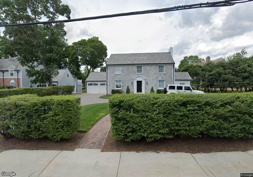
29 Waban Ave Waban, MA 02468
Waban NeighborhoodEstimated Value: $2,338,176 - $2,599,000
4
Beds
4
Baths
3,096
Sq Ft
$799/Sq Ft
Est. Value
About This Home
This home is located at 29 Waban Ave, Waban, MA 02468 and is currently estimated at $2,474,294, approximately $799 per square foot. 29 Waban Ave is a home located in Middlesex County with nearby schools including Angier Elementary School, Charles E Brown Middle School, and Newton South High School.
Ownership History
Date
Name
Owned For
Owner Type
Purchase Details
Closed on
Jul 2, 2004
Sold by
Barsamian Joan Anne
Bought by
Malkasian Patricia F
Current Estimated Value
Home Financials for this Owner
Home Financials are based on the most recent Mortgage that was taken out on this home.
Original Mortgage
$500,000
Interest Rate
6.3%
Mortgage Type
Purchase Money Mortgage
Purchase Details
Closed on
Nov 7, 1994
Sold by
Est Riordan John Jr and Riordan John J
Bought by
Barsamian Joan Anne
Home Financials for this Owner
Home Financials are based on the most recent Mortgage that was taken out on this home.
Original Mortgage
$300,000
Interest Rate
8.71%
Mortgage Type
Purchase Money Mortgage
Create a Home Valuation Report for This Property
The Home Valuation Report is an in-depth analysis detailing your home's value as well as a comparison with similar homes in the area
Home Values in the Area
Average Home Value in this Area
Purchase History
| Date | Buyer | Sale Price | Title Company |
|---|---|---|---|
| Malkasian Patricia F | $1,375,000 | -- | |
| Barsamian Joan Anne | $363,000 | -- |
Source: Public Records
Mortgage History
| Date | Status | Borrower | Loan Amount |
|---|---|---|---|
| Open | Barsamian Joan Anne | $400,000 | |
| Closed | Malkasian Patricia F | $500,000 | |
| Previous Owner | Barsamian Joan Anne | $300,000 |
Source: Public Records
Tax History Compared to Growth
Tax History
| Year | Tax Paid | Tax Assessment Tax Assessment Total Assessment is a certain percentage of the fair market value that is determined by local assessors to be the total taxable value of land and additions on the property. | Land | Improvement |
|---|---|---|---|---|
| 2025 | $19,393 | $1,978,900 | $1,392,300 | $586,600 |
| 2024 | $18,752 | $1,921,300 | $1,351,700 | $569,600 |
| 2023 | $17,978 | $1,766,000 | $1,051,500 | $714,500 |
| 2022 | $17,202 | $1,635,200 | $973,600 | $661,600 |
| 2021 | $16,598 | $1,542,600 | $918,500 | $624,100 |
| 2020 | $16,105 | $1,542,600 | $918,500 | $624,100 |
| 2019 | $15,651 | $1,497,700 | $891,700 | $606,000 |
| 2018 | $15,231 | $1,407,700 | $806,300 | $601,400 |
| 2017 | $14,767 | $1,328,000 | $760,700 | $567,300 |
| 2016 | $14,124 | $1,241,100 | $710,900 | $530,200 |
| 2015 | $13,466 | $1,159,900 | $664,400 | $495,500 |
Source: Public Records
Map
Nearby Homes
- 18 Annawan Rd
- 20 Kinmonth Rd Unit 203
- 20 Kinmonth Rd Unit 306
- 34 Pilgrim Rd
- 1801 Beacon St
- 115 Windsor Rd
- 29 Montclair Rd
- 33 Metacomet Rd
- 80 Pine Ridge Rd
- 873 Chestnut St
- 131 Oliver Rd
- 10 Lorraine Cir
- 1430 Beacon St
- 120 Stanley Rd
- 177 Varick Rd
- 25 Allen Ave
- 34 Palmer Rd
- 181 Saint Mary St
- 187 Saint Mary St
- 992 Chestnut St