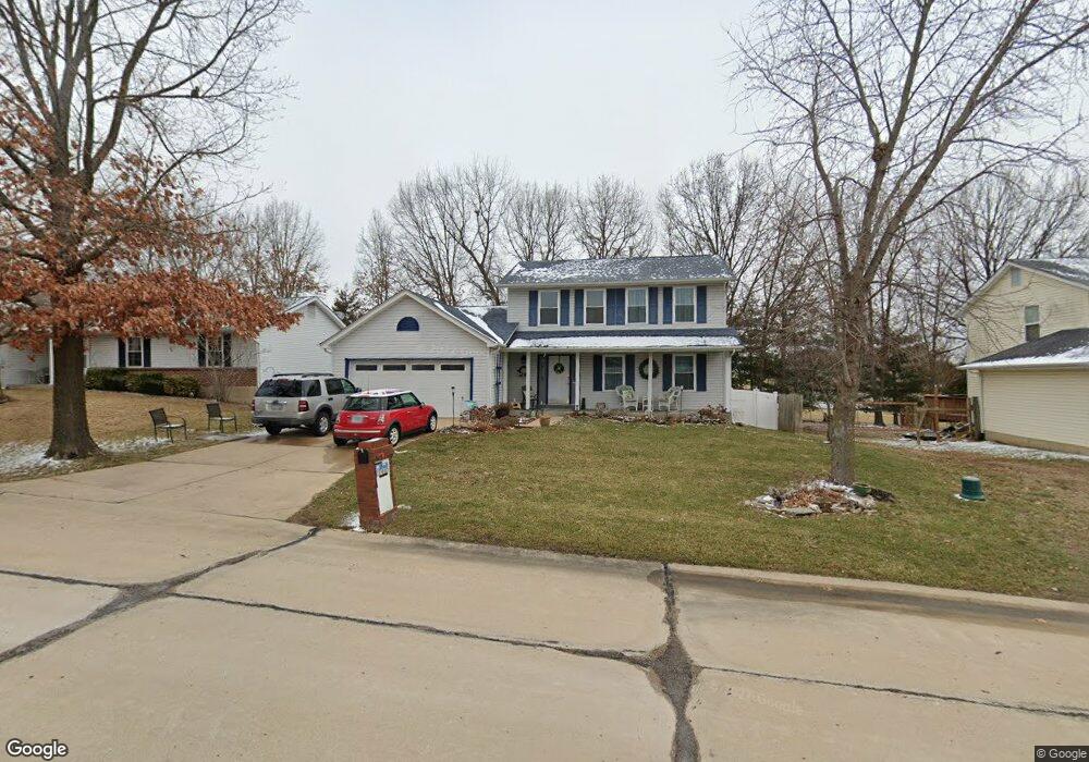
2912 Wheatfield Farms Dr O Fallon, MO 63368
Estimated Value: $311,000 - $356,000
3
Beds
3
Baths
1,757
Sq Ft
$190/Sq Ft
Est. Value
About This Home
This home is located at 2912 Wheatfield Farms Dr, O Fallon, MO 63368 and is currently estimated at $334,512, approximately $190 per square foot. 2912 Wheatfield Farms Dr is a home located in St. Charles County with nearby schools including Pheasant Point Elementary School, Fort Zumwalt South Middle School, and Fort Zumwalt South High School.
Ownership History
Date
Name
Owned For
Owner Type
Purchase Details
Closed on
Jun 25, 2024
Sold by
Mason Michael M and Mason Teresa M
Bought by
Michael M Mason And Teresa M Mason Revocable
Current Estimated Value
Purchase Details
Closed on
Sep 26, 2016
Sold by
Cuba Katherine J
Bought by
Mason Michael M
Home Financials for this Owner
Home Financials are based on the most recent Mortgage that was taken out on this home.
Original Mortgage
$142,400
Interest Rate
3.43%
Mortgage Type
New Conventional
Create a Home Valuation Report for This Property
The Home Valuation Report is an in-depth analysis detailing your home's value as well as a comparison with similar homes in the area
Home Values in the Area
Average Home Value in this Area
Purchase History
| Date | Buyer | Sale Price | Title Company |
|---|---|---|---|
| Michael M Mason And Teresa M Mason Revocable | -- | None Listed On Document | |
| Mason Michael M | -- | Nations Title Agency Of Miss |
Source: Public Records
Mortgage History
| Date | Status | Borrower | Loan Amount |
|---|---|---|---|
| Previous Owner | Mason Michael M | $142,400 |
Source: Public Records
Tax History Compared to Growth
Tax History
| Year | Tax Paid | Tax Assessment Tax Assessment Total Assessment is a certain percentage of the fair market value that is determined by local assessors to be the total taxable value of land and additions on the property. | Land | Improvement |
|---|---|---|---|---|
| 2025 | $3,385 | $54,317 | -- | -- |
| 2023 | $3,388 | $51,324 | $0 | $0 |
| 2022 | $2,992 | $42,219 | $0 | $0 |
| 2021 | $2,999 | $42,219 | $0 | $0 |
| 2020 | $2,504 | $33,870 | $0 | $0 |
| 2019 | $2,510 | $33,870 | $0 | $0 |
| 2018 | $2,746 | $35,494 | $0 | $0 |
| 2017 | $2,701 | $35,494 | $0 | $0 |
| 2016 | $2,616 | $33,024 | $0 | $0 |
| 2015 | $2,439 | $33,024 | $0 | $0 |
| 2014 | $2,266 | $30,257 | $0 | $0 |
Source: Public Records
Map
Nearby Homes
- 691 Logan Valley Dr
- 1228 Cold Spring Dr
- 1218 Cold Spring Dr
- 6355 Sprucefield Dr
- 60 Loganberry Ct
- 817 Brimley Dr
- 421 Jacobs Place Dr
- 661 Clifton Hill Dr
- 201 Dardenne Farms Dr
- 225 Jacobs Way
- 1 Pauley Cir
- 212 Jacobs Way
- 28 Tailor Ct
- 202 Sunshine Dr
- 32 Gulf Shores Dr
- 367 Shamrock St
- 361 Shamrock St
- 7 Park City Ct
- 6 Royallglen Ct
- 213 Black Oak Dr
- 2916 Wheatfield Farms Dr
- 2908 Wheatfield Farms Dr
- 2920 Wheatfield Farms Dr
- 2904 Wheatfield Farms Dr
- 2913 Wheatfield Farms Dr
- 2909 Wheatfield Farms Dr
- 2917 Wheatfield Farms Dr
- 100 Lac Terre Ct
- 2924 Wheatfield Farms Dr
- 2921 Wheatfield Farms Dr
- 2900 Wheatfield Farms Dr
- 5 White Stable Ct
- 97 Lac Terre Ct
- 2928 Wheatfield Farms Dr
- 2925 Wheatfield Farms Dr
- 2882 White Stable Dr
- 3 White Stable Ct
- 6 White Stable Ct
- 98 Lac Terre Ct
- 2929 Wheatfield Farms Dr