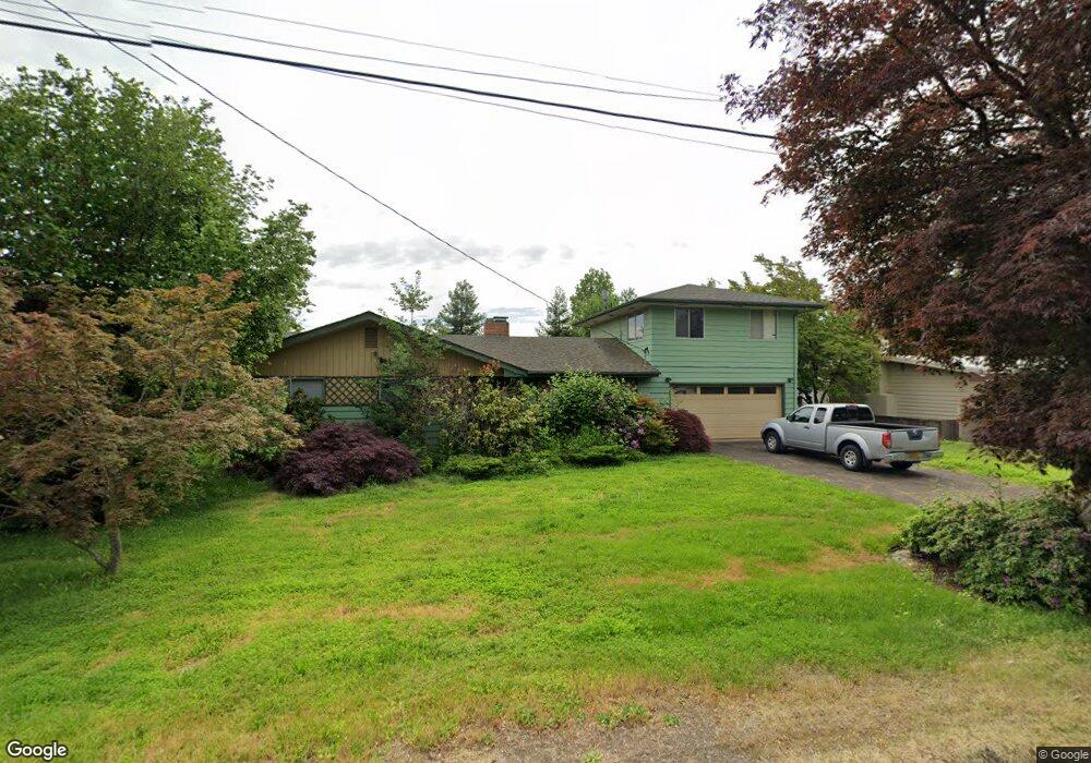
2957 Crocker Rd Eugene, OR 97404
Santa Clara NeighborhoodEstimated Value: $465,051 - $530,000
5
Beds
3
Baths
1,866
Sq Ft
$261/Sq Ft
Est. Value
About This Home
This home is located at 2957 Crocker Rd, Eugene, OR 97404 and is currently estimated at $487,263, approximately $261 per square foot. 2957 Crocker Rd is a home located in Lane County with nearby schools including Spring Creek Elementary School, Madison Middle School, and North Eugene High School.
Ownership History
Date
Name
Owned For
Owner Type
Purchase Details
Closed on
Nov 4, 2009
Sold by
Mcclosky Peter J and Peter J Mcclosky Trust
Bought by
Mcclosky Peter J and Peter J Mcclosky Trust
Current Estimated Value
Purchase Details
Closed on
Aug 9, 2005
Sold by
Gelker Thomas Bruce
Bought by
Mcclosky Peter J
Home Financials for this Owner
Home Financials are based on the most recent Mortgage that was taken out on this home.
Original Mortgage
$184,000
Interest Rate
5.48%
Mortgage Type
Fannie Mae Freddie Mac
Purchase Details
Closed on
Nov 1, 2000
Sold by
Gelker Gail Judith
Bought by
Gelker Thomas Bruce
Purchase Details
Closed on
Sep 7, 1995
Sold by
Schultz Edward F
Bought by
Schultz Edward F and Edward F Schultz Revocable Trust
Purchase Details
Closed on
Oct 12, 1984
Sold by
Smith Phern
Bought by
Phillips John R and Phillips Suzan A
Create a Home Valuation Report for This Property
The Home Valuation Report is an in-depth analysis detailing your home's value as well as a comparison with similar homes in the area
Home Values in the Area
Average Home Value in this Area
Purchase History
| Date | Buyer | Sale Price | Title Company |
|---|---|---|---|
| Mcclosky Peter J | $10,900 | None Available | |
| Mcclosky Peter J | -- | None Available | |
| Mcclosky Peter J | $230,000 | American Title Group | |
| Gelker Thomas Bruce | -- | -- | |
| Schultz Edward F | -- | -- | |
| Phillips John R | $50,000 | Western Title & Escrow Co |
Source: Public Records
Mortgage History
| Date | Status | Borrower | Loan Amount |
|---|---|---|---|
| Previous Owner | Mcclosky Peter J | $184,000 |
Source: Public Records
Tax History
| Year | Tax Paid | Tax Assessment Tax Assessment Total Assessment is a certain percentage of the fair market value that is determined by local assessors to be the total taxable value of land and additions on the property. | Land | Improvement |
|---|---|---|---|---|
| 2025 | $3,290 | $257,038 | -- | -- |
| 2024 | $3,273 | $249,552 | -- | -- |
| 2023 | $3,273 | $242,284 | $0 | $0 |
| 2022 | $3,076 | $235,228 | $0 | $0 |
| 2021 | $2,822 | $228,377 | $0 | $0 |
| 2020 | $2,875 | $221,726 | $0 | $0 |
| 2019 | $2,769 | $215,268 | $0 | $0 |
| 2018 | $2,549 | $202,912 | $0 | $0 |
| 2017 | $2,368 | $202,912 | $0 | $0 |
| 2016 | $2,217 | $197,002 | $0 | $0 |
| 2015 | $2,165 | $191,264 | $0 | $0 |
| 2014 | $2,008 | $185,693 | $0 | $0 |
Source: Public Records
Map
Nearby Homes
- 2721 La Darrah St
- 3256 Marvin Dr
- 805 Impala Ave
- 349 Irving Rd
- 2563 York St
- 374 Blackfoot Ave
- 541 Durham Ave
- 2987 Dry Creek Rd
- 2965 Teal Place
- 200 Irving Rd
- 2488 Northampton
- 2931 Shelby Way
- 1256 Frogs Leap Ln
- 303 Lenore Loop
- 215 Jonquil Ave
- 2418 Kalmia St
- 1265 Napa Creek Dr
- 2610 Crowther Dr
- 2580 Crowther Dr
- 193 Santa Clara Ave
- 2975 Crocker Rd
- 2929 Crocker Rd
- 2966 Brett Loop
- 2970 Brett Loop
- 2962 Brett Loop
- 2986 Brett Loop
- 2966 Crocker Rd
- 2940 Crocker Rd
- 2993 Crocker Rd
- 2919 Crocker Rd
- 2958 Brett Loop
- 2990 Crocker Rd
- 3004 Brett Loop
- 2920 Crocker Rd
- 2965 Alyndale Dr
- 2937 Brett Loop
- 2969 Brett Loop
- 2941 Alyndale Dr
- 3015 Crocker Rd
- 2895 Crocker Rd
Your Personal Tour Guide
Ask me questions while you tour the home.