
Seller's Agent in 2025
Suzanne Schumann
Coldwell Banker Realty
(860) 778-6982
1 in this area
93 Total Sales
Estimated Value: $298,000 - $362,000
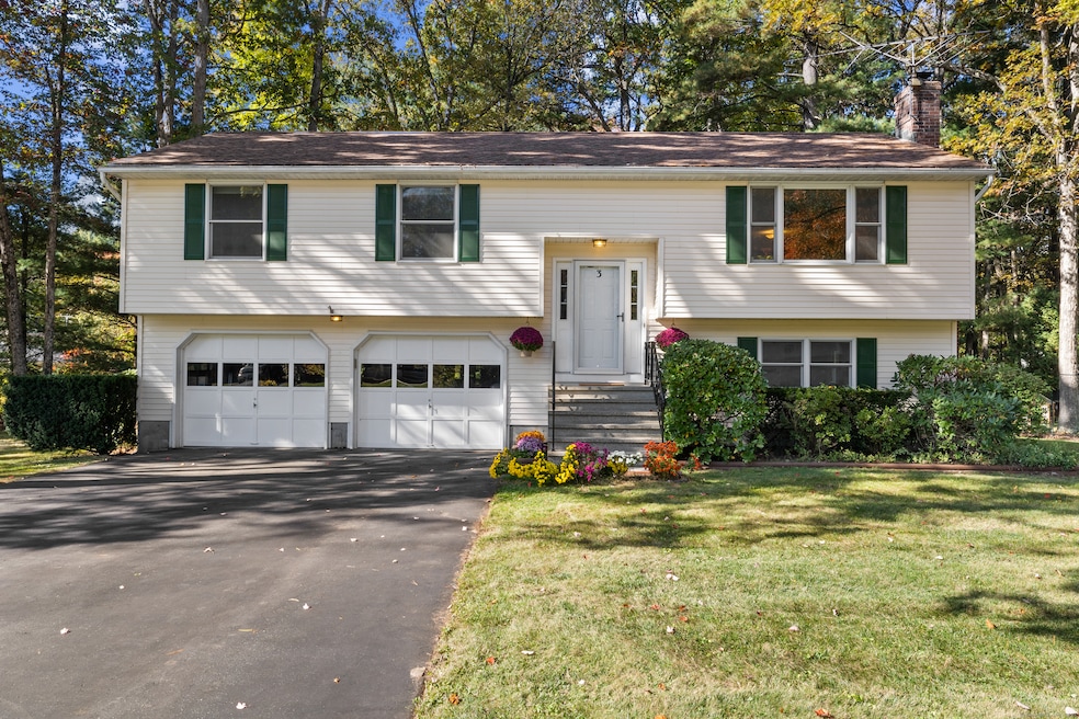
Discover the peaceful charm of 3 East Forrest Drive. Step inside and you'll find a bright, open-concept layout filled with natural light. The spacious living room features a cozy fireplace, perfect for crisp autumn evenings and relaxed winter gatherings with friends. The layout is ideal for entertaining, with a spacious dining area that features sliding doors to a deck - a great spot to enjoy morning coffee or host summer dinners, all while overlooking the gorgeous, wooded backyard. All three bedrooms feature hardwood floors and ample closet space, and the full bath includes double sinks for added convenience. Looking for more space? This home has it! The finished lower level adds incredible versatility with a large rec room warmed by a pellet stove - perfect for movie nights, a home gym, or a game room. This level also includes a half bath, laundry area, and direct access to the attached two-car garage. Outside, enjoy the low-maintenance vinyl siding and a spacious lawn, perfect for play, gardening, or relaxing in the fresh air. All of this in an amazing location, close to shopping and with easy highway access! Don't miss it!
Last Agent to Sell the Property
Coldwell Banker Realty Brokerage Phone: (860) 778-6982 License #RES.0766631 Listed on: 10/21/2025
| Date | Buyer | Sale Price | Title Company |
|---|---|---|---|
| Danielczuk John | $160,000 | -- |
| Date | Status | Borrower | Loan Amount |
|---|---|---|---|
| Closed | Danielczuk John | $90,300 | |
| Closed | Danielczuk John | $128,000 |
| Date | Event | Price | List to Sale | Price per Sq Ft |
|---|---|---|---|---|
| 11/20/2025 11/20/25 | Sold | $365,000 | +9.0% | $215 / Sq Ft |
| 11/17/2025 11/17/25 | Pending | -- | -- | -- |
| 10/23/2025 10/23/25 | For Sale | $335,000 | -- | $197 / Sq Ft |
| Year | Tax Paid | Tax Assessment Tax Assessment Total Assessment is a certain percentage of the fair market value that is determined by local assessors to be the total taxable value of land and additions on the property. | Land | Improvement |
|---|---|---|---|---|
| 2025 | $5,599 | $161,600 | $54,100 | $107,500 |
| 2024 | $5,464 | $161,600 | $54,100 | $107,500 |
| 2023 | $5,375 | $161,600 | $54,100 | $107,500 |
| 2022 | $49 | $161,600 | $54,100 | $107,500 |
| 2021 | $4,747 | $126,980 | $44,770 | $82,210 |
| 2020 | $4,747 | $126,980 | $44,770 | $82,210 |
| 2019 | $4,747 | $126,980 | $44,770 | $82,210 |
| 2018 | $4,641 | $126,980 | $44,770 | $82,210 |
| 2017 | $4,391 | $126,980 | $44,770 | $82,210 |
| 2016 | $4,259 | $125,240 | $44,770 | $80,470 |
| 2015 | $4,138 | $125,240 | $44,770 | $80,470 |
| 2014 | $4,043 | $125,240 | $44,770 | $80,470 |
Seller's Agent in 2025
Suzanne Schumann
Coldwell Banker Realty
(860) 778-6982
1 in this area
93 Total Sales
Buyer's Agent in 2025
Rodney Motta
Berkshire Hathaway Home Services
(860) 849-6467
7 in this area
140 Total Sales
Source: SmartMLS
MLS Number: 24135085
APN: ENFI-000077-000000-000047
Disclaimer: Certain information contained herein is derived from information provided by parties other than Homes.com. All information provided is deemed reliable, but is not guaranteed to be accurate and should be independently verified.
![]() IDX information is provided exclusively for personal, non-commercial use, and may not be used for any purpose other than to identify prospective properties consumers may be interested in purchasing. Information is deemed reliable but not guaranteed.
IDX information is provided exclusively for personal, non-commercial use, and may not be used for any purpose other than to identify prospective properties consumers may be interested in purchasing. Information is deemed reliable but not guaranteed.
Ask me questions while you tour the home.