Estimated Value: $552,000 - $664,000
3
Beds
3
Baths
1,692
Sq Ft
$349/Sq Ft
Est. Value
About This Home
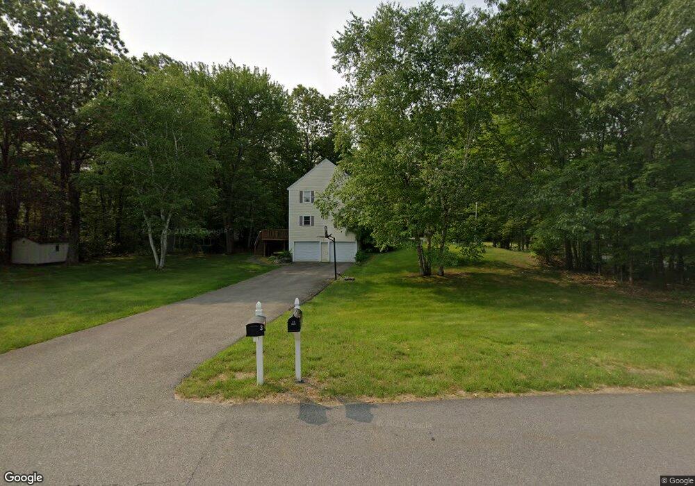
This home is located at 3 Eastgate Rd, Derry, NH 03038 and is currently estimated at $590,594, approximately $349 per square foot. 3 Eastgate Rd is a home located in Rockingham County with nearby schools including Ernest P. Barka Elementary School, Gilbert H. Hood Middle School, and Pinkerton Academy.
Ownership History
Date
Name
Owned For
Owner Type
Purchase Details
Closed on
Jan 6, 2006
Sold by
Curl Phillip B
Bought by
Ames Lisa B
Current Estimated Value
Home Financials for this Owner
Home Financials are based on the most recent Mortgage that was taken out on this home.
Original Mortgage
$225,000
Interest Rate
6.28%
Mortgage Type
Purchase Money Mortgage
Purchase Details
Closed on
Aug 10, 2005
Sold by
Harantis Cove Llc
Bought by
Diblasi Philip N and Diblasi Tina F
Home Financials for this Owner
Home Financials are based on the most recent Mortgage that was taken out on this home.
Original Mortgage
$373,400
Interest Rate
5.54%
Mortgage Type
Purchase Money Mortgage
Purchase Details
Closed on
Feb 2, 1999
Sold by
Aubrey Scott P and Aubrey Deborah M
Bought by
Curl Phillip B
Home Financials for this Owner
Home Financials are based on the most recent Mortgage that was taken out on this home.
Original Mortgage
$151,650
Interest Rate
6.67%
Create a Home Valuation Report for This Property
The Home Valuation Report is an in-depth analysis detailing your home's value as well as a comparison with similar homes in the area
Home Values in the Area
Average Home Value in this Area
Purchase History
| Date | Buyer | Sale Price | Title Company |
|---|---|---|---|
| Ames Lisa B | $329,000 | -- | |
| Diblasi Philip N | $476,600 | -- | |
| Curl Phillip B | $168,500 | -- |
Source: Public Records
Mortgage History
| Date | Status | Borrower | Loan Amount |
|---|---|---|---|
| Open | Curl Phillip B | $233,750 | |
| Closed | Curl Phillip B | $225,000 | |
| Previous Owner | Curl Phillip B | $373,400 | |
| Previous Owner | Curl Phillip B | $151,650 |
Source: Public Records
Tax History Compared to Growth
Tax History
| Year | Tax Paid | Tax Assessment Tax Assessment Total Assessment is a certain percentage of the fair market value that is determined by local assessors to be the total taxable value of land and additions on the property. | Land | Improvement |
|---|---|---|---|---|
| 2024 | $9,444 | $505,300 | $209,900 | $295,400 |
| 2023 | $8,979 | $434,200 | $178,400 | $255,800 |
| 2022 | $8,267 | $434,200 | $178,400 | $255,800 |
| 2021 | $7,708 | $311,300 | $136,300 | $175,000 |
| 2020 | $7,577 | $311,300 | $136,300 | $175,000 |
| 2019 | $7,656 | $293,100 | $105,200 | $187,900 |
| 2018 | $7,629 | $293,100 | $105,200 | $187,900 |
| 2017 | $7,711 | $267,200 | $95,200 | $172,000 |
| 2016 | $7,230 | $267,200 | $95,200 | $172,000 |
| 2015 | $7,229 | $247,300 | $95,200 | $152,100 |
| 2014 | $7,276 | $247,300 | $95,200 | $152,100 |
| 2013 | $7,161 | $227,400 | $87,200 | $140,200 |
Source: Public Records
Map
Nearby Homes
- 80 Bypass 28
- 1 Barkland Dr
- 27 Cove Dr
- 7 Gena Ave
- 6 Hilda Ave
- 5 Tsienneto Rd Unit 10
- 5 Tsienneto Rd Unit 127
- 5 Tsienneto Rd Unit 170
- 5 Tsienneto Rd Unit 41
- 5 Tsienneto Rd Unit 151
- 8 Mark Ave
- 9 Dattillo Rd
- 80.5 English Range Rd
- 4 Viza Ave
- 2 Pembroke Dr Unit 21
- 70 English Range Rd
- 3 Pembroke Dr Unit 20
- 51 Chester Rd
- 4 Newells Meadow Ln Unit 2
- 2 Silvestri Cir Unit 13