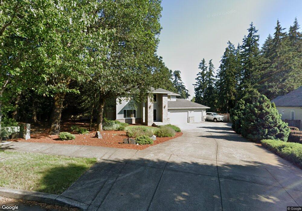
3026 Blacktail Dr Eugene, OR 97405
Churchill NeighborhoodEstimated Value: $823,636 - $877,000
4
Beds
3
Baths
2,662
Sq Ft
$322/Sq Ft
Est. Value
About This Home
This home is located at 3026 Blacktail Dr, Eugene, OR 97405 and is currently estimated at $856,909, approximately $321 per square foot. 3026 Blacktail Dr is a home located in Lane County with nearby schools including Adams Elementary School, Arts And Technology Academy At Jefferson, and Churchill High School.
Ownership History
Date
Name
Owned For
Owner Type
Purchase Details
Closed on
Mar 1, 2005
Sold by
Piculell Arthur C
Bought by
Phillips T Y and Phillips Darcy J
Current Estimated Value
Home Financials for this Owner
Home Financials are based on the most recent Mortgage that was taken out on this home.
Original Mortgage
$84,500
Interest Rate
6.02%
Mortgage Type
Purchase Money Mortgage
Create a Home Valuation Report for This Property
The Home Valuation Report is an in-depth analysis detailing your home's value as well as a comparison with similar homes in the area
Home Values in the Area
Average Home Value in this Area
Purchase History
| Date | Buyer | Sale Price | Title Company |
|---|---|---|---|
| Phillips T Y | $125,945 | Western Pioneer Title Co |
Source: Public Records
Mortgage History
| Date | Status | Borrower | Loan Amount |
|---|---|---|---|
| Previous Owner | Phillips T Y | $84,500 |
Source: Public Records
Tax History
| Year | Tax Paid | Tax Assessment Tax Assessment Total Assessment is a certain percentage of the fair market value that is determined by local assessors to be the total taxable value of land and additions on the property. | Land | Improvement |
|---|---|---|---|---|
| 2025 | $10,288 | $528,045 | -- | -- |
| 2024 | $10,160 | $512,666 | -- | -- |
| 2023 | $10,160 | $497,734 | $0 | $0 |
| 2022 | $9,518 | $483,237 | $0 | $0 |
| 2021 | $8,851 | $469,163 | $0 | $0 |
| 2020 | $8,648 | $455,499 | $0 | $0 |
| 2019 | $8,417 | $442,233 | $0 | $0 |
| 2018 | $7,965 | $416,848 | $0 | $0 |
| 2017 | $7,561 | $416,848 | $0 | $0 |
| 2016 | $7,203 | $404,707 | $0 | $0 |
| 2015 | $7,024 | $392,919 | $0 | $0 |
| 2014 | $6,838 | $381,475 | $0 | $0 |
Source: Public Records
Map
Nearby Homes
- 2565 Braewood Ln
- 2030 W 34th Ave
- 2870 Hawkins Ln
- 3320 Videra Dr
- 2090 Graham Dr
- 2728 Hallmark Ln
- 0 Brighton Ave Unit 446 19051229
- 3828 Ashford Dr
- 0 Hallmark Ln
- 0 Aerie Park Place Unit 563784902
- 0 Aerie Park Place Unit 625628092
- 0 Aerie Park Place Unit 595870203
- 0 Mountain Ash Blvd Unit 410068044
- 3825 Brighton Ave
- 2315 W 28th Ave
- 2850 Garfield St
- 2610 Park Forest Dr
- 3574 Colony Oaks Dr Unit 6
- 3586 Colony Oaks Dr Unit 5
- 0 Lorane Hwy Unit 1-3-5-A
- 3008 Blacktail Dr
- 3044 Blacktail Dr
- 0 Cimarron Place
- 3011 Blacktail Dr
- 3078 Blacktail Dr
- 3033 Blacktail Dr
- 2986 Blacktail Dr
- 3321 Michael Ln
- 2993 Blacktail Dr
- 3068 Cimarron Place
- 3065 Cimarron Place
- 2954 Blacktail Dr
- 3285 Michael Ln
- 2941 Blacktail Dr
- 3105 Earlasue St
- 2922 Blacktail Dr
- 3259 Michael Ln
- 3133 Blacktail Dr
- 2909 Blacktail Dr
- 3079 Cimarron Place
Your Personal Tour Guide
Ask me questions while you tour the home.