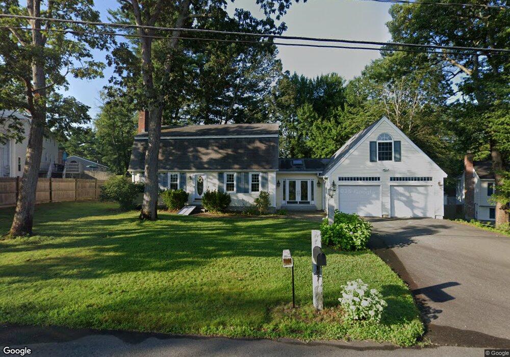
31 Dunloggin Rd Nashua, NH 03063
Northwest Nashua NeighborhoodEstimated Value: $584,000 - $712,000
4
Beds
2
Baths
1,800
Sq Ft
$345/Sq Ft
Est. Value
About This Home
This home is located at 31 Dunloggin Rd, Nashua, NH 03063 and is currently estimated at $620,763, approximately $344 per square foot. 31 Dunloggin Rd is a home located in Hillsborough County with nearby schools including Birch Hill Elementary School, Elm Street Middle School, and Nashua High School North.
Ownership History
Date
Name
Owned For
Owner Type
Purchase Details
Closed on
Aug 19, 2024
Sold by
Moffitt Douglas C and Moffitt Jill A
Bought by
J Moffitt & D Moffitt Ft and Moffitt
Current Estimated Value
Purchase Details
Closed on
Apr 10, 1985
Bought by
Moffitt Douglas C and Moffitt Jill A
Create a Home Valuation Report for This Property
The Home Valuation Report is an in-depth analysis detailing your home's value as well as a comparison with similar homes in the area
Home Values in the Area
Average Home Value in this Area
Purchase History
| Date | Buyer | Sale Price | Title Company |
|---|---|---|---|
| J Moffitt & D Moffitt Ft | -- | None Available | |
| J Moffitt & D Moffitt Ft | -- | None Available | |
| Moffitt Douglas C | $92,900 | -- |
Source: Public Records
Tax History Compared to Growth
Tax History
| Year | Tax Paid | Tax Assessment Tax Assessment Total Assessment is a certain percentage of the fair market value that is determined by local assessors to be the total taxable value of land and additions on the property. | Land | Improvement |
|---|---|---|---|---|
| 2024 | $7,527 | $473,400 | $163,600 | $309,800 |
| 2023 | $7,323 | $401,700 | $130,900 | $270,800 |
| 2022 | $7,259 | $401,700 | $130,900 | $270,800 |
| 2021 | $6,553 | $282,200 | $91,600 | $190,600 |
| 2020 | $6,396 | $282,900 | $91,600 | $191,300 |
| 2019 | $6,156 | $282,900 | $91,600 | $191,300 |
| 2018 | $6,000 | $282,900 | $91,600 | $191,300 |
| 2017 | $6,141 | $238,100 | $74,800 | $163,300 |
| 2016 | $5,969 | $238,100 | $74,800 | $163,300 |
| 2015 | $5,841 | $238,100 | $74,800 | $163,300 |
| 2014 | $5,726 | $238,100 | $74,800 | $163,300 |
Source: Public Records
Map
Nearby Homes
- 19 Dunloggin Rd
- 7 Robert Dr
- 3 Wright Rd
- 239 Broad St
- 22 Berkshire Rd
- 74 Profile Cir
- 123 Cannongate III
- 5 Chatfield Dr Unit U18
- 4 Jared Cir Unit U21
- 11 Amherst Terrace
- 33 Ferry Rd
- 31 Ashland St
- 3 Paddington Place
- 0 Baldwin St
- 7 Bitirnas St Unit U7
- 17 Danbury Rd
- 61 Manchester St
- 4 Reservoir St
- 424 Broad St
- 31 Juliana Ave